


Get to know Linxiang
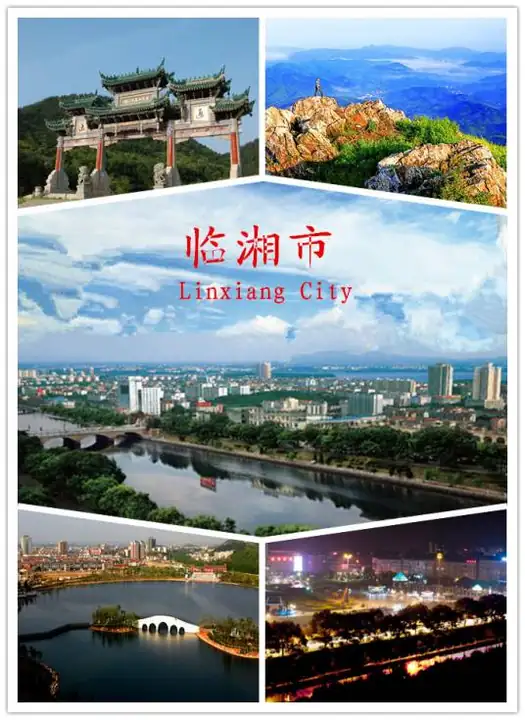
Photo adjustments
EXIF orientation normalized; resized without changing aspect ratio; converted to WebP. No subject edits.
- Administrative area
- County-level city · 县级市
- Part of
- Yueyang
- Chinese name
- 临湘市
- Local areas
- County-level city guide
Area & population
- Area in the source
- 1,718.00 km²
- Population · 2017
- 570,000
Source: cited geographic source, as of the dates shown.
Setting and landscape
The land falls from south to north: peaks in the southeast, rolling hills in the centre and open plain in the northwest. Yaogu Mountain (药姑山) in the east is the highest point at 1,261.1 metres, while Guhuazhou (谷花洲) in Jiangnan town sits at 23 metres. The Taolin (桃林河), Tandu (坦渡河) and Yuantan (源潭河) rivers all run north into the Yangtze, which follows the city's edge for 38.5 kilometres. Huanggai Lake (黄盖湖) lies on the northern border with Chibi (赤壁).
History
A Ming gazetteer of Yuezhou explains the name as land beside the waters of the Xiang. Between 934 and 936 the Ma clan (马氏) set up a post called Wangchao (王朝场) at Lucheng (陆城) on the Yangtze; it became Wangchao County in 994 and was renamed Linxiang in 996. The county seat stayed at Lucheng, which was cut off by water in the flood season, until it moved to Chang'an (长安) in 1930. Lucheng is now part of Yunxi District (云溪区). Linxiang became a county-level city in 1992.
Linxiang huagu opera (临湘花鼓戏), locally called wengqin opera (嗡琴戏), grew from folk songs in the Taolin River basin. It entered the national intangible heritage list in 2011, and its tunes keep clear traces of Yao music.
What to see
Nieshi old street runs for about a kilometre along the Nieshi River (聂市河), which flows north through Huanggai Lake to the Yangtze. Tea trading made it busy under the Ming and Qing, and by the Guangxu reign it had more than 200 shops and the nickname "Little Hankou". Its 45 riverside buildings mix central Shanxi and Huizhou styles and have been a provincial protected site since 2011.
Longjiao Mountain, a provincial scenic area, is presented as Qianjiadong (千家峒), an early home of the Yao people. The stone-pile tombs there, in Longyuan village (龙源村) of Yanglousi town (羊楼司镇), are a national key protected site. Wujianshan (五尖山), in Chang'an subdistrict where the city government sits, is a national forest park.
Food and local products
Named local foods include Shisancun pickles (十三村酱菜), whose making is on Hunan's first provincial heritage list, Taolin tofu (桃林豆腐), Zhanqiao eight-flavour fermented black beans (詹桥八味豆豉) and Linxiang green brick tea (临湘青砖茶). Yanglousi has a national market for bamboo ware.
Getting oriented
The Beijing–Guangzhou railway, the Wuhan–Guangzhou high-speed railway and the Beijing–Hong Kong–Macau and Hangzhou–Ruili expressways cross the city. Changsha lies 150 kilometres to the south and Wuhan 150 kilometres to the north.
Highlights
- Nieshi old street 聂市老街: Kilometre-long riverside tea-trade street with 45 Ming-Qing buildings; provincial protected site since 2011.
- Longjiao Mountain 龙窖山: Provincial scenic area presented as an early Yao homeland, with nationally protected stone-pile tombs.
- Linxiang huagu opera 临湘花鼓戏: Local opera from the Taolin River basin on the national intangible heritage list since 2011.
- Linxiang green brick tea 临湘青砖茶: Pressed tea named among the city's noted farm products.
Sources for this guide
临湘市 - 维基百科,自由的百科全书 · Wikipedia (Chinese) · CC BY-SA 4.0
花鼓戏(临湘花鼓戏) - 中国非物质文化遗产网·中国非物质文化遗产数字博物馆 - 中国非物质文化遗产网非遗 · China Intangible Cultural Heritage Network (ihchina.cn)
国家地名词典(临湘) · Linxiang City People's Government (city gazetteer office)
Original English written from the listed sources and checked sentence by sentence against quoted extracts by a separate reviewer. Updated 2026-09-25.
Explore Linxiang
Core places to explore, with English and Chinese names.
Plan your visit
Getting there
Linxiang is about 35 km in a straight line from central Yueyang. Search for 临湘市 in a map app to find stations and your accommodation.
Where to stay →More in Yueyang
Sources & geographic information
Administrative names and parent areas: Official geographic directory · Reference date 2026-09-06.
Some facts checked against 临湘市 — Wikipedia contributors, CC BY-SA 4.0.
Map data © OpenStreetMap contributors. Pins mark approximate centres, not entrances or boundaries.