


Get to know Yueyang County
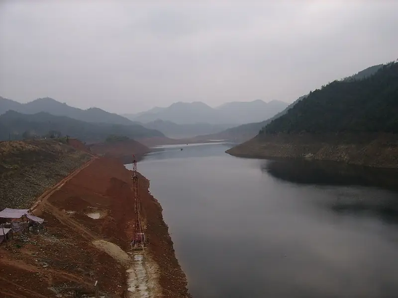
Photo adjustments
Full frame retained; EXIF orientation normalized, proportionally resized to at most 800 pixels and converted to WebP. No generated pixels or subject changes. Cards may crop the display.
- Administrative area
- County · 县
- Part of
- Yueyang
- Chinese name
- 岳阳县
- Local areas
- County guide
Area & population
- Area in the source
- 2,905.00 km²
Source: cited geographic source, as of the dates shown.
Setting and landscape
The county government describes hills in the east, rolling uplands in the middle and a network of lakes in the west. The ground steps down from spurs of the Mufu Mountains (幕阜山) in the northeast toward East Dongting Lake (东洞庭湖) in the southwest, and water covers about 40 percent of the county. Most of its 63 streams drain into East Dongting, the main ones being the Xinqiang (新墙河), Feijia (费家河) and Pingqiao (坪桥河) rivers. Tieshan Reservoir (铁山水库), a lake of many islands that holds 630 million cubic metres, supplies water to Yueyang city.
History
Baling County was created in 280 under the Western Jin, from the western part of Xiajuan (下隽), and then covered today's county, Linxiang (临湘) and the urban area of Yueyang. The county seat moved out of Yueyang city to Rongjiawan (荣家湾) in 1978, and the present county was re-established in 1983 when Yueyang became a prefecture-level city. The county government lists Shang and Zhou sites, the Lujiao kilns (鹿角古窑) and Lingyun Pagoda (凌云宝塔) among its relics, and the essayist Wu Minshu (吴敏树) among its natives.
What to see
Zhang Guying Village stands below Bijia Mountain (笔架山) where Yueyang County, Pingjiang (平江) and Miluo (汨罗) meet. Building began in 1562 under the Ming Jiajing emperor and was extended twice in the Qing. The complex is made up of three groups, Dangdamen (当大门), Wangjiaduan (王家塅) and Shangxinwu (上新屋), with 62 lanes, 206 skywells and 1,732 rooms; halls are arranged around the skywells, and the drainage system survives complete. The village became a national key cultural relic in 2001 and a Chinese historic village in 2003, and the county calls it a "folk Forbidden City" (民间故宫).
Dayun Mountain (大云山) is a national forest park that the county government describes as a Taoist holy mountain since ancient times; it and the Zhang Guying scenic area are both national AAAA scenic areas. The county government also describes Dongting Lake as a national nature reserve and counts the Xinqiang River among its sites of the War of Resistance against Japan.
Getting oriented
The county borders Tongcheng (通城) in Hubei to the east, Pingjiang to the southeast, Miluo to the south and Huarong (华容) to the west, with Yueyang's urban districts and Linxiang to the north. The county seat adjoins the city, over 100 kilometres from Changsha and 200 from Wuhan. The Beijing–Guangzhou railway, the Wuhan–Guangzhou high-speed railway and the Beijing–Hong Kong–Macau expressway serve the county.
Highlights
- Zhang Guying Village 张谷英村: Village compound begun in 1562 with 206 skywells and 1,732 rooms; national key cultural relic since 2001.
- Dayun Mountain National Forest Park 大云山国家森林公园: Forest park on a mountain the county describes as a Taoist holy site; national AAAA scenic area.
- Tieshan Reservoir 铁山水库: Island-studded reservoir holding 630 million cubic metres that supplies Yueyang city.
- Xinqiang River 新墙河: Main river of the county, which the county government counts among its sites of the War of Resistance against Japan.
Sources for this guide
岳阳县 - 维基百科,自由的百科全书 · Wikipedia (Chinese) · CC BY-SA 4.0
张谷英村 - 维基百科,自由的百科全书 · Wikipedia (Chinese) · CC BY-SA 4.0
岳阳县概况-岳阳县人民政府 · Yueyang County People's Government
Original English written from the listed sources and checked sentence by sentence against quoted extracts by a separate reviewer. Updated 2026-09-25.
Explore Yueyang County
Core places to explore, with English and Chinese names.
Places to explore around Yueyang County
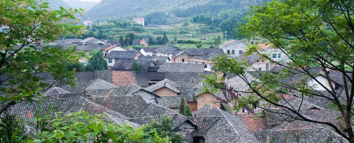 Rooftops of the historic Zhang Gu Ying Cun (Zhangguying Village) settlement in Yueyang County ·
 Plan your visit
Getting there
Yueyang County is about 25 km in a straight line from central Yueyang. Search for 岳阳县 in a map app to find stations and your accommodation.
Where to stay →Build your route
Start with Zhangguying Village. The linked place guides have entrance and visit details.
Continue with Yueyang →More in Yueyang
Sources & geographic information
Administrative names and parent areas: Official geographic directory (dmfw.mca.gov.cn) · Reference date 2026-09-06.
Some facts checked against 岳阳县 — Wikipedia contributors, CC BY-SA 4.0.
Some facts checked against 张谷英村 — Wikipedia contributors, CC BY-SA 4.0.
Photo: Zhangguying Village · SquirrelLee · CC BY-SA 3.0. Full frame retained; proportionally resized and converted to WebP. No retouching or changes to the photographed subject. Card displays may crop the view.

Map data © OpenStreetMap contributors. Pins mark approximate centres, not entrances or boundaries.