


Get to know Miluo
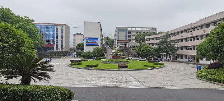
Photo adjustments
EXIF orientation normalized; resized without changing aspect ratio; converted to WebP. No subject edits.
- Administrative area
- County-level city · 县级市
- Part of
- Yueyang
- Chinese name
- 汨罗市
- Local areas
- County-level city guide
Area & population
- Population · 2017
- 685,000
Source: cited geographic source, as of the dates shown.
Setting and landscape
The city sits where the Mufu Mountains (幕阜山脉) give way to the Dongting Lake plain (洞庭湖平原), so the ground falls from hills in the southeast to lakeside flats in the northwest. The highest point is Damo Ridge (达摩岭), the main peak of Mount Yuchi (玉池山), at 777.5 metres. The Miluo River and its two branches, the Mi (汨江) and the Luo (罗水), form the fifth-largest river system feeding Dongting Lake, after the Xiang, Zi, Yuan and Li rivers.
History and heritage
Finds at the Fushanyuan site (附山园遗址) show people living beside the Miluo River at least 9,000 years ago. After King Wu of Chu (楚武王) destroyed the state of Luo (罗国) in 690 BC, its people built a walled town, Luocheng (罗城), on the south bank near the river's mouth; the Qin made it the seat of Luo County in 221 BC. Miluo County was carved out of eastern Xiangyin (湘阴) in 1966 and became a city in 1987.
The Dragon Boat Festival customs along the Miluo River entered the first national intangible heritage list in 2006. Here the festival runs from the first to the fifteenth day of the fifth lunar month. Besides rice dumplings and boat races, riverside villages carve dragon heads, "steal the sacred wood" (偷神木), sing praise verses, launch the boats and make offerings to Qu Yuan. Changle storytelling (长乐故事会) was added to the national list in 2011.
What to see
The Qu Zi Temple (屈子祠), also called the Qu Yuan Temple, stands at the foot of Mount Yusi (玉笥山) beside the Miluo River. It was founded in the Han dynasty and moved to its present site after floods in the Qianlong reign of the Qing; the south-facing brick and timber building standing today is the Qianlong rebuilding, and its gateways carry 13 relief carvings of Qu Yuan. It became a national key cultural relic in 2001. A stele forest of 356 inscribed stones was added on its east side in 1995.
Mount Yuchi is where Tao Dan (陶淡) of the Jin dynasty built a hut to make elixirs, and its dozens of scenic spots include the "ten caves and eight lakes".
Getting oriented
Miluo has Dongting Lake to the west, Changsha (长沙) to the south and Yueyang to the north. The Beijing–Guangzhou railway, the Beijing–Guangzhou high-speed railway and the Beijing–Zhuhai expressway all cross the city.
Highlights
- Qu Zi Temple 屈子祠: Temple to Qu Yuan on Mount Yusi by the Miluo River, moved here and rebuilt under Qianlong; national key cultural relic since 2001.
- Miluo River Dragon Boat Festival 汨罗江畔端午习俗: National intangible heritage since 2006, with dragon-head carving, boat launching and offerings to Qu Yuan.
- Mount Yuchi 玉池山: Its main peak, Damo Ridge, is the highest point in Miluo; Tao Dan of the Jin dynasty made elixirs here.
- Changle storytelling 长乐故事会: Local tradition added to the national intangible heritage list in 2011.
Sources for this guide
汨罗市 - 维基百科,自由的百科全书 · Wikipedia (Chinese) · CC BY-SA 4.0
端午节(汨罗江畔端午习俗) - 中国非物质文化遗产网·中国非物质文化遗产数字博物馆 · China Intangible Cultural Heritage Network (Ministry of Culture and Tourism)
屈子祠 - 维基百科,自由的百科全书 · Wikipedia (Chinese) · CC BY-SA 4.0
Original English written from the listed sources and checked sentence by sentence against quoted extracts by a separate reviewer. Updated 2026-09-25.
Explore Miluo
Core places to explore, with English and Chinese names.
Places to explore around Miluo
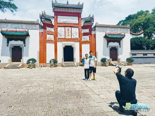 Quzi Cultural Park ·
 Plan your visit
Getting there
Miluo is about 65 km in a straight line from central Yueyang. Search for 汨罗市 in a map app to find stations and your accommodation.
Where to stay →Build your route
Start with Quzi Cultural Park. The linked place guides have entrance and visit details.
Continue with Yueyang →More in Yueyang
Sources & geographic information
Administrative names and parent areas: Official geographic directory · Reference date 2026-09-06.
Some facts checked against 汨罗市 — Wikipedia contributors, CC BY-SA 4.0.
Some facts checked against 屈子祠 — Wikipedia contributors, CC BY-SA 4.0.
Photo: Quzi Cultural Park · Source photographer · License not provided. EXIF orientation normalized; resized without changing aspect ratio; converted to WebP. No subject edits.
Map data © OpenStreetMap contributors. Pins mark approximate centres, not entrances or boundaries.