


Get to know Urad Front Banner
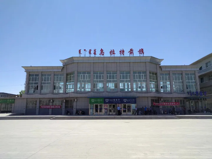
Photo adjustments
Full frame retained; proportionally resized and converted to WebP. No retouching or changes to the photographed subject. Card displays may crop the view.
- Administrative area
- Banner · 旗
- Part of
- Bayannur
- Chinese name
- 乌拉特前旗
- Local areas
- Banner guide
Area & population
- Area in the source
- 7,460.00 km²
- Population · 2020
- 257,826
- Administrative seat
- Ulashan
Source: cited geographic source, as of the dates shown.
Setting and landscape
The banner describes its terrain as "three mountains, two valleys, one lake, a thousand-li plain and two flats". The three ranges are the Wula, Chashitai (查石太山) and Baiyinchagan (白音察汉山) mountains; the highest point, Dahuabei (大桦背) in the Wula Mountains, reaches 2,322 metres. The two valleys are Ming'an (明安川) and Xiaoshetai (小佘太川). Some 4,900 square kilometres are dry hill country and about 2,500 are irrigated with Yellow River water.
What to see
Wuliangsuhai Lake, whose Mongolian name means "poplar grove", is a river-formed lake on an old course of the Yellow River, 35 to 40 km from north to south and about 293 square kilometres in area. It is fed mainly by tail water from the Hetao irrigation canals, and part of its water drains back to the Yellow River. More than 20 kinds of fish, including carp and Yellow River dace, are caught there, and more than 120 bird species use it, among them mute swans, whooper swans and spot-billed pelicans. The Wuliangsuhai Ecological Tourism Area in Erdenbulag Sum (额尔登布拉格苏木) was graded 4A in 2023.
At Baiyanhua (白彦花镇), the Monishan Spring tourist area (莫尼山泉旅游区), also called the Urad tribe, is a 3A site.
History
The banner government traces its history to the Warring States, when King Wuling of Zhao (赵武灵王) built the towns of Anyang (安阳) and Jiuyuan (九原) here and a section of the Zhao Great Wall; the Qin then set up Jiuyuan Commandery. In 1648 the Qing created the three Urad banners; the front banner was known as the West Duke Banner (西公旗). Anbei County (安北县) was merged into the banner in 1958. The banner seat, Wulashan town (乌拉山镇), was founded in 1954 as Xishanzui (西山咀镇).
Food and local products
"Zhaojun Red" (昭君红) goji berries were chosen for the national "one county, one product" scheme, and Ming'an astragalus (明安黄芪) and Wula Mountain mutton (乌拉山羊肉) are listed as notable national farm products.
Highlights
- Wuliangsuhai Lake 乌梁素海: Lake of about 293 square kilometres on an old Yellow River course; more than 120 bird species.
- Dahuabei peak 大桦背: Highest point of the Wula Mountains at 2,322 metres.
- Monishan Spring tourist area 莫尼山泉旅游区: 3A site at Baiyanhua.
- Zhaojun Red goji 昭君红枸杞: Chosen for the national one-county-one-product scheme.
Sources for this guide
乌拉特前旗 - 维基百科,自由的百科全书 · Wikipedia (Chinese) · CC BY-SA 4.0
旗情概况 · Urad Front Banner People's Government
历史沿革 · Urad Front Banner People's Government
乌梁素海 - 维基百科,自由的百科全书 · Wikipedia (Chinese) · CC BY-SA 4.0
巴彦淖尔市A级旅游区名录 · Bayannur Culture, Tourism, Radio and Television Bureau
Original English written from the listed sources and checked sentence by sentence against quoted extracts by a separate reviewer. Updated 2026-09-25.
Explore Urad Front Banner
Core places to explore, with English and Chinese names.
Places to explore around Urad Front Banner
 Lakeside boardwalk and boat-dock marker at Wuliangsuhai Lake, Ulad Front Banner ·
 Plan your visit
Getting there
Urad Front Banner is about 105 km in a straight line from central Bayannur. Search for 乌拉特前旗 in a map app to find stations and your accommodation.
Where to stay →Build your route
Start with Wuliangsuhai Lake. The linked place guides have entrance and visit details.
Continue with Bayannur →More in Bayannur
Sources & geographic information
Administrative names and parent areas: Official geographic directory · Reference date 2026-09-06.
Some facts checked against 乌拉特前旗 — Wikipedia contributors, CC BY-SA 4.0.
Some facts checked against 乌梁素海 — Wikipedia contributors, CC BY-SA 4.0.
Photo: Wuliangsuhai Lake · fish4fish · CC BY-SA 3.0. Full frame retained; proportionally resized and converted to WebP. No retouching or changes to the photographed subject. Card displays may crop the view.

Map data © OpenStreetMap contributors. Pins mark approximate centres, not entrances or boundaries.