


Get to know Ulanhot

Photo adjustments
Full frame retained; proportionally resized and converted to WebP. No retouching or changes to the photographed subject. Card displays may crop the view.
- Administrative area
- County-level city · 县级市
- Part of
- Hinggan League
- Chinese name
- 乌兰浩特市
- Local areas
- County-level city guide
Area & population
- Area in the source
- 772.00 km²
- Population · 2020
- 356,035
- Administrative seat
- Heping Subdistrict
Source: cited geographic source, as of the dates shown.
History
The city grew up around a family temple built in 1691 by Ochir (鄂齐尔), third-generation prince of the Jasagtu banner (札萨克图旗), which local people called Wangyemiao (王爷庙), the prince's temple. After its abbot translated Buddhist scriptures from Tibetan into Manchu and Mongolian in Beijing, the Kangxi Emperor named the temple Puhui Si (普慧寺), and Wangyemiao stuck as the name of the town.
In 1947 the Inner Mongolian People's Congress met here from 23 April to 1 May and elected an autonomous government with Ulanhu (乌兰夫) as chairman. That year Wangyemiao was renamed Ulanhot and made a city. The congress met in a two-storey grey-brick hall built in 1935 as the auditorium of a Manchukuo military academy; the State Council listed it as a nationally protected site in 2006.
Setting and landscape
The land is higher in the northwest, with uplands in the north and an alluvial plain in the south, and the city looks south over the Songnen Plain (松嫩平原). Besides the Taoer and Guiliu, the Erdao (二道河) and Amugulang (阿木古郎河) rivers cross the city area, and the Chaersen Reservoir (察尔森水库) lies on the upper Taoer.
What to see
The Genghis Khan Temple (成吉思汗庙) stands on top of Han Mountain. It was built from 1941 to 1944 with money raised among Mongols across Manchukuo, and damaged in the Cultural Revolution. The present buildings were finished in 1987. Its 28-metre main hall, flanked by two side halls under round domes, holds a gilded bronze seated figure of Genghis Khan 2.8 metres tall, with murals of his achievements; the city lists the temple area as a national 4A scenic area.
Gegenmiao town (葛根庙镇) has a memorial square to the "8·11" anti-Japanese uprising, a horse culture museum and apricot groves that flower in April. Sanhe village (三合村), in the southern part of the eastern outskirts where three rivers meet, has a long history of rice growing, a Korean folk museum, a rice story hall and Korean dishes such as gimbap, kimchi and grilled meat.
Highlights
- Genghis Khan Temple 成吉思汗庙: Domed shrine on Han Mountain built 1941–1944, rebuilt by 1987, with a 2.8-metre gilded bronze Genghis Khan.
- Inner Mongolian autonomous government assembly hall 内蒙古自治政府成立大会会址: 1935 hall where the autonomous government was elected in 1947; nationally protected since 2006.
- Sanhe village 三合村: Rice-growing village where three rivers meet, with a Korean folk museum and Korean food.
- Gegenmiao town 葛根庙镇: Uprising memorial square, horse culture museum and April apricot blossom.
Sources for this guide
乌兰浩特概况_乌兰浩特市人民政府 · Ulanhot Municipal People's Government
文化历史_乌兰浩特市人民政府 · Ulanhot Municipal People's Government
精品旅游_乌兰浩特市人民政府 · Ulanhot Municipal People's Government
成吉思汗庙 - 维基百科,自由的百科全书 · Wikipedia · CC BY-SA 4.0
红色马镇-葛根庙_乌兰浩特市人民政府 · Ulanhot Municipal People's Government
中国少数民族特色村寨-三合村_乌兰浩特市人民政府 · Ulanhot Municipal People's Government
内蒙古自治政府成立大会会址 - 维基百科,自由的百科全书 · Wikipedia · CC BY-SA 4.0
Original English written from the listed sources and checked sentence by sentence against quoted extracts by a separate reviewer. Updated 2026-09-26.
Explore Ulanhot
Core places to explore, with English and Chinese names.
Places to explore around Ulanhot
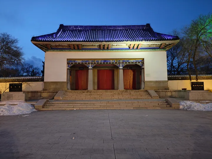 The Genghis Khan Temple in Genghis Khan Park, Ulanhot, at dusk ·
 Plan your visit
Getting there
Ulanhot covers the centre of Hinggan League. Search for 乌兰浩特市 in a map app to find stations and your accommodation.
Where to stay →Build your route
Start with Genghis Khan Temple. The linked place guides have entrance and visit details.
Continue with Hinggan League →More in Hinggan League
Sources & geographic information
Administrative names and parent areas: Official geographic directory · Reference date 2026-09-06.
Some facts checked against 成吉思汗庙 — Wikipedia contributors, CC BY-SA 4.0.
Some facts checked against 内蒙古自治政府成立大会会址 — Wikipedia contributors, CC BY-SA 4.0.
Photo: Genghis Khan Temple · HCCB3947 · CC BY 4.0. Full frame retained; proportionally resized and converted to WebP. No retouching or changes to the photographed subject. Card displays may crop the view.

Map data © OpenStreetMap contributors. Pins mark approximate centres, not entrances or boundaries.