


Get to know Tianning District

Photo adjustments
Full frame retained; proportionally resized and converted to WebP. No retouching or changes to the photographed subject. Card displays may crop the view.
- Administrative area
- District · 市辖区
- Part of
- Changzhou
- Chinese name
- 天宁区
- Local areas
- District guide
Area & population
- Area in the source
- 153.93 km²
- Population · 2020
- 668,906
Source: cited geographic source, as of the dates shown.
What to see
Tianning Temple stands outside the old east gate of Changzhou. It was founded in the Tang dynasty, between 627 and 655, as Guangfu Temple (光福寺), and took its present name in 1111. The Qianlong Emperor came to burn incense there three times and wrote a plaque for it. Badly damaged during the Cultural Revolution, it was restored from 1979 and in 1983 was named a national key Buddhist temple. Its Luohan Hall holds 500 luohan figures, and 518 carved stone luohan panels line the walls of the main hall. Behind the temple, Tianning Pagoda (天宁宝塔), rebuilt from late 2005 in Tang and Song style, has 13 octagonal storeys and rises 153.79 metres.
Qingguo Lane (青果巷) is an 800-metre lane that the district government calls the birthplace of more than a hundred noted people, among them Sheng Xuanhuai (盛宣怀), Qu Qiubai (瞿秋白) and Zhao Yuanren (赵元任). It runs east–west along the north bank of the Nanshi River (南市河), once part of the Grand Canal through Changzhou. The fruit trade on the river banks earned it the name Qianguo, "thousand fruits", and because "thousand" and "green" sound alike in Changzhou dialect it also came to be called Qingguo. Jinling Middle Road divides it, with the eastern part in Tianning.
The district government also names the gardens Jinyuan (近园), Yueyuan (约园) and Yiyuan (意园), Hongmei Park (红梅公园) and Dongpo Park (东坡公园), and lists Jiaoxi old town (焦溪古镇) and the Sidun archaeological site (寺墩遗址) among its more than one hundred protected heritage sites. Hongmei Park contains the Wenbi Pagoda (文笔塔) and Hongmei Pavilion (红梅阁).
Getting oriented
Changzhou railway station and the city's long-distance bus station are in Tianning, and the Shanghai–Nanjing high-speed railway, the new course of the Grand Canal and the Shanghai–Nanjing Expressway all cross the district. Of the four boundary changes in its history, three brought in new ground: three subdistricts of the abolished Guanghua District in 1987, four townships of the former suburban district in 2002, and Zhenglu town (郑陆镇) from Wujin in 2015.
Highlights
- Tianning Temple 天宁寺: Tang-dynasty foundation, named a national key Buddhist temple in 1983; gives the district its name.
- Tianning Pagoda 天宁宝塔: Thirteen-storey octagonal pagoda, 153.79 metres, rebuilt behind the temple from late 2005.
- Qingguo Lane 青果巷: 800-metre lane along the Nanshi River, home of Sheng Xuanhuai, Qu Qiubai and Zhao Yuanren.
- Hongmei Park 红梅公园: Park containing the Wenbi Pagoda and Hongmei Pavilion.
Sources for this guide
天宁简介 · Tianning District People's Government, Changzhou
天宁区 · Wikipedia (Chinese) · CC BY-SA 4.0
天宁寺 (常州) · Wikipedia (Chinese) · CC BY-SA 4.0
青果巷 · Wikipedia (Chinese) · CC BY-SA 4.0
Original English written from the listed sources and checked sentence by sentence against quoted extracts by a separate reviewer. Updated 2026-09-25.
Explore Tianning District
Core places to explore, with English and Chinese names.
Places to explore around Tianning District
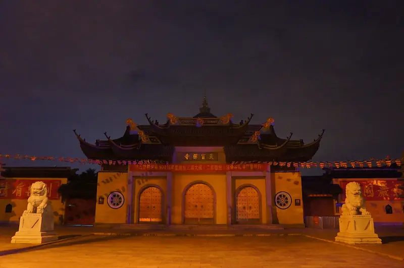 Changzhou Tianning Temple (天宁寺), Tianning District. Photograph: "201610 Tianning Temple, Changzhou".
Changzhou Tianning Temple天宁寺
Tianning Temple in central Changzhou combines a monastery with Tang-period origins and a thirteen-storey pagoda completed in 2007.
Read the place guide →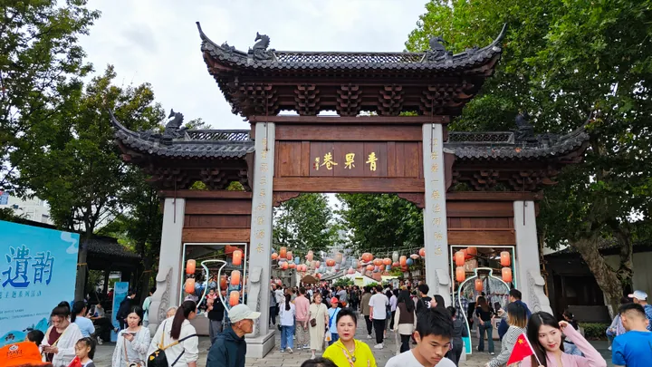 The main gate arch of Qing Guo Xiang (Qingguo Lane) with crowds passing beneath it, in Tianning District, Changzhou. · 常州市天宁区青果巷牌坊大门,游人熙攘。 Source-recorded photograph date: 2024-10-01 14:39:35.
Qingguo Lane青果巷
Old Changzhou street on a former Grand Canal channel, lined with Ming Tang family halls and the birthplaces of Qu Qiubai and Zhou Youguang.
Read the place guide →Plan your visit
Getting there
Tianning District is about 3 km in a straight line from central Changzhou. Search for 天宁区 in a map app to find stations and your accommodation.
Where to stay →Build your route
Changzhou Tianning Temple and Qingguo Lane are both listed here. The linked place guides have entrance and visit details.
Continue with Changzhou →More in Changzhou
Sources & geographic information
Administrative names and parent areas: Official geographic directory · Reference date 2026-09-06.
Some facts checked against 天宁区 — Wikipedia contributors, CC BY-SA 4.0.
Some facts checked against 天宁寺 (常州) — Wikipedia contributors, CC BY-SA 4.0.
Some facts checked against 青果巷 — Wikipedia contributors, CC BY-SA 4.0.
Photo: Changzhou Tianning Temple · MNXANL · CC BY-SA 4.0. Full frame retained; EXIF orientation normalized, proportionally resized to at most 800 pixels and converted to WebP. No generated pixels or subject changes. Cards may crop the display.

Photo: Qingguo Lane · Cz2018764171 · CC BY-SA 4.0. Full frame retained; proportionally resized and converted to WebP. No retouching or changes to the photographed subject. Card displays may crop the view.

Map data © OpenStreetMap contributors. Pins mark approximate centres, not entrances or boundaries.