


Get to know Danyang

Photo adjustments
Full frame retained; proportionally resized and converted to WebP. No retouching or changes to the photographed subject. Card displays may crop the view.
- Administrative area
- County-level city · 县级市
- Part of
- Zhenjiang
- Chinese name
- 丹阳市
- Local areas
- County-level city guide
Area & population
- Area in the source
- 1,047.00 km²
- Population · 2020 census
- 988,900
Source: cited geographic source, as of the dates shown.
Setting and landscape
Danyang slopes from northwest to southeast. Low hills, outliers of the Ningzhen hills (宁镇丘陵), cover the west and north, where Crystal Mountain (水晶山) is the highest peak at 166 metres; the east and south are flat land on the western side of the Taihu plain, mostly around 7 metres above sea level. The Grand Canal, the Jiuqu River (九曲河) and the Danjinli canal (丹金溧漕河) form the backbone of its waterways. Across the Yangtze to the northeast lies Yangzhong (扬中市). Groundwater here is mostly karst water that comes up at 45 to 48°C, which the city government describes as hot-spring water.
History
The city counts more than 2,400 years as a walled town. It was the fief of Jizi of Yanling (延陵季子), a Spring and Autumn period figure honoured for his virtue, and the home of the emperors of the Southern Qi and Liang dynasties (齐梁). It began as the settlement of Yunyang (云阳邑) in the Warring States period, became Yunyang County under Qin in 221 BC and was soon renamed Qu'e. Qu'e County was renamed Danyang County in AD 742 under the Tang. Danyang became a county-level city in December 1987.
What to see
The city government calls Danyang a "land of cultural relics south of the Yangtze" (江南文物之邦). Eleven sites are national protected monuments, among them the stone carvings of the Southern Dynasties imperial tombs (南朝陵墓石刻) and the Gecheng site (葛城遗址). Provincial listings include the Tang-dynasty stele of Jizi of Yanling (延陵季子碑) and a Tang bronze temple bell cast in the Zhonghe reign (唐中和铜钟), which the city government calls the foremost Buddhist bell south of the Yangtze. Parks in the city include the Fenghuangshan site park (凤凰山遗址公园) and the Qi-Liang culture forest park (齐梁文化森林公园).
Local performing arts include Dan opera (丹剧), a rare regional form developed from the folk art called "langdang" (啷当).
Food and local products
Danyang styles itself the "capital of eyeglasses" (眼镜之都) and makes spectacle frames as well as optical-glass and resin lenses. The low hills in the north yield axe-cut stone (斧劈石) and ornamental rocks, which the city government rates as high in quality.
Highlights
- Southern Dynasties tomb stone carvings 南朝陵墓石刻: One of the city's eleven national protected monuments.
- Gecheng Site 葛城遗址: National protected monument.
- Stele of Jizi of Yanling 延陵季子碑: Tang-dynasty stele on the provincial protection list.
- Zhonghe-era Tang bronze bell 唐中和铜钟: Provincially protected bell called the foremost Buddhist bell south of the Yangtze.
Sources for this guide
丹阳简介 · Danyang Municipal People's Government
自然地理 · Danyang Municipal People's Government
建置沿革 · Danyang Municipal People's Government
文化文物 · Danyang Municipal People's Government
Original English written from the listed sources and checked sentence by sentence against quoted extracts by a separate reviewer. Updated 2026-09-25.
Explore Danyang
Core places to explore, with English and Chinese names.
Places to explore around Danyang
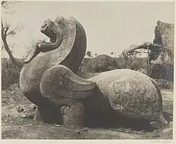 Southern Dynasties Tomb Stone Carvings ·
 Plan your visit
Getting there
Danyang is about 25 km in a straight line from central Zhenjiang. Search for 丹阳市 in a map app to find stations and your accommodation.
Where to stay →Build your route
Start with Southern Dynasties Tomb Stone Carvings. The linked place guides have entrance and visit details.
Continue with Zhenjiang →More in Zhenjiang
Sources & geographic information
Administrative names and parent areas: Official geographic directory · Reference date 2026-09-06.
Photo: Southern Dynasties Tomb Stone Carvings · Source photographer · License not provided. EXIF orientation normalized; resized without changing aspect ratio; converted to WebP. No subject edits.
Map data © OpenStreetMap contributors. Pins mark approximate centres, not entrances or boundaries.