


Get to know Jingkou District
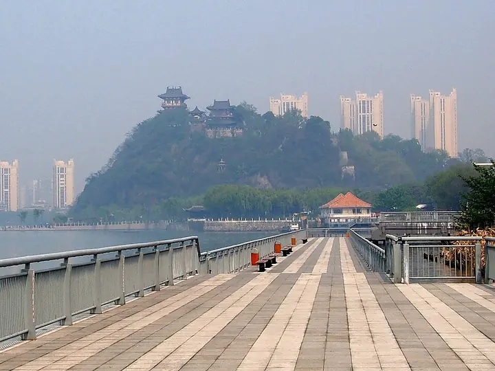
Photo adjustments
Full frame retained; proportionally resized and converted to WebP. No retouching or changes to the photographed subject. Card displays may crop the view.
- Administrative area
- District · 市辖区
- Part of
- Zhenjiang
- Chinese name
- 京口区
- Local areas
- District guide
Area & population
- Population · 2010
- 601,671
Source: cited geographic source, as of the dates shown.
Setting and landscape
The district lies at the eastern end of the Ningzhen hills (宁镇山脉), where low hills meet the Yangtze alluvial plain. The ground is higher in the middle and flat to the east, the west and along the river, and a chain of hills runs north to south through the centre: Jiao Hill, Beigu Hill, Xiang Hill (象山), Jingxian Hill (京岘山) and others. Apart from Xinmin Island (新民洲), a sandbank in the Yangtze, most of the district is hilly. The Yangtze runs 11 kilometres through it and the Grand Canal 5.7 kilometres, meeting the river at Jianbi (谏壁). Runzhou District (润州区) faces it across the old canal to the west.
History
Jingkou is one of the old names of Zhenjiang: high, level ground was called jing and the river mouth below Beigu Hill was called kou. Sun Quan (孙权) of Eastern Wu built the Tieweng walled town (铁瓮城) here and made Jingkou the political centre of his state. After the Yongjia upheaval of the Jin dynasty, northern gentry families moved south and provinces were set up for them at Jingkou. The Sui named the area Runzhou (润州), and the Song raised it to Zhenjiang prefecture, a name still in use. In spring 1929 the Jiangsu provincial capital moved from Nanjing to Zhenjiang, with its seat in Jingkou. The city's urban district took the name Jingkou District in December 1983.
What to see
The district government describes Jiao Hill as a hill that wraps around its temple and Beigu Hill as a temple that crowns its hill. Jiao Hill's Dinghui Temple (定慧寺) dates, according to Wikipedia, to the Xingping era of the Eastern Han; it was earlier called Jiaoshan Temple and received its present name when the Kangxi Emperor visited on a southern tour. The Jiao Hill Stele Forest (焦山碑林), a nationally protected site, keeps about 80 cliff inscriptions and more than 400 steles, led by the Yihe Ming (瘗鹤铭), the "Inscription for a Buried Crane", and carvings in the hands of Su Shi (苏轼), Mi Fu (米芾), Huang Tingjian (黄庭坚) and Lu You (陆游).
The iron pagoda of Ganlu Temple (甘露寺铁塔) on Beigu Hill, the Huju Bridge (虎踞桥) and the Tieweng walled town are also national protected sites. Mengxi Garden (梦溪园), built in 1085, is where the Northern Song scientist Shen Kuo (沈括) lived until 1092 and wrote his Dream Pool Essays (梦溪笔谈). Provincial protected sites include Wuliu Hall (五柳堂), the Zhang Yunpeng former residence (张云鹏故居) and the tomb of Zong Ze (宗泽墓).
Highlights
- Jiao Hill 焦山: Hill whose Dinghui Temple the district government lists as a national key temple.
- Jiao Hill Stele Forest 焦山碑林: National protected site with about 80 cliff inscriptions and more than 400 steles, including the Yihe Ming.
- Beigu Hill 北固山: Hill whose Ganlu Temple iron pagoda is a national protected site; the river mouth below it gave Jingkou its name.
- Mengxi Garden 梦溪园: Built in 1085; Shen Kuo lived here until 1092 and wrote the Dream Pool Essays.
Sources for this guide
京口概况 | 京口区人民政府 · Jingkou District People's Government, Zhenjiang
京口区 - 维基百科,自由的百科全书 · Chinese Wikipedia · CC BY-SA 4.0
Original English written from the listed sources and checked sentence by sentence against quoted extracts by a separate reviewer. Updated 2026-09-25.
Explore Jingkou District
Core places to explore, with English and Chinese names.
Places to explore around Jingkou District
Beigu Mountain seen from the riverside, photographed in 2015 · 北固山 Photograph date recorded by the source: Taken on 18 April 2015.Beigu Mountain北固山
Beigu Mountain rises on the southern bank of the Yangtze in northeastern Zhenjiang. Its historic landscape is organized around a series of low peaks and linked ridges.
Read the place guide →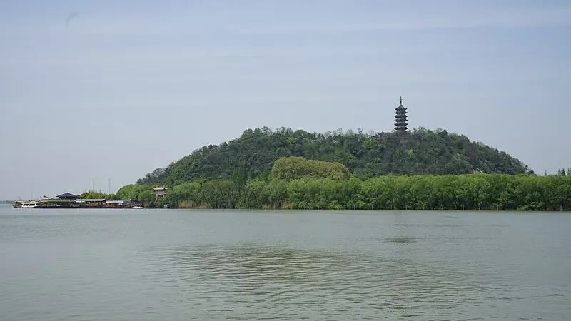 Jiaoshan and its pagoda viewed across the water. Photograph date recorded by the source: 2017-04-14 12:33:52.
Jiaoshan焦山
Jiaoshan is a wooded island hill in the Yangtze north of Zhenjiang. Dinghui Temple is set among the trees, giving the religious buildings a different relationship with the landscape from nearby Jinshan.
Read the place guide → AI illustration · AI 示意图(仅供参考,非该地点实拍)
Mount Jinshan金山
Former Yangtze island in Zhenjiang covered by Jinshan Temple, with a summit pagoda, the White Snake legend and a rebuilt imperial library.
Read the place guide →Plan your visit
Getting there
Jingkou District is about 4 km in a straight line from central Zhenjiang. Search for 京口区 in a map app to find stations and your accommodation.
Where to stay →Build your route
Beigu Mountain and Jiaoshan are about 3 km apart in a straight line. The linked place guides have entrance and visit details.
Continue with Zhenjiang →More in Zhenjiang
Sources & geographic information
Administrative names and parent areas: Official geographic directory · Reference date 2026-09-06.
Some facts checked against 京口区 — Wikipedia contributors, CC BY-SA 4.0.
Photo: Beigu Mountain · rheins · CC BY 3.0. Full frame retained; proportionally resized and converted to WebP. No retouching or changes to the photographed subject. Card displays may crop the view.
.jpg)
Photo: Jiaoshan · Huangchenhai · CC BY-SA 4.0. Full frame retained; proportionally resized and converted to WebP. No retouching or changes to the photographed subject. Card displays may crop the view.

Map data © OpenStreetMap contributors. Pins mark approximate centres, not entrances or boundaries.