


Get to know Chaoyang District
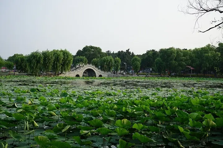
Photo adjustments
The exact downloaded source bytes are separately retained and hashed. Prepared JPEG is proportionally reduced to a maximum 720-pixel long edge; full frame retained, no subject alteration. Final website rendition: full frame retained, proportionally resized to at most 720 pixels and converted to WebP. No additional retouching or subject alteration. Card displays may crop the view.
- Administrative area
- District · 市辖区
- Part of
- Changchun
- Chinese name
- 朝阳区
- Local areas
- District guide
Area & population
- Area in the source
- 346.00 km²
- Population · 2020 census
- 614,021
- Administrative seat
- Qianjin Subdistrict
Source: cited geographic source, as of the dates shown.
History
Farm villages formed here from the early Jiaqing reign of the Qing, settled by farm families who came in the Chuang Guandong (闯关东) migration to the northeast. After Manchukuo was founded in 1932, the area fell inside the planned new city of Xinjing (新京), and its fields were built over. Planners made Xinmin Street (新民大街) the north–south axis and put up a group of ministry buildings near it, known together as the Eight Ministries (八大部). The district took its present name in July 1955, from the East and West Chaoyang Roads inside it; until then it had been Zhonghua District (中华区).
What to see
Six of the Eight Ministries buildings survive; the former agriculture and education ministries were pulled down in 1998 and 2002. In 2013 the six survivors were listed with other Manchukuo government and Japanese military buildings, among them the Imperial Palace, as a major national protected site. Xinmin Street, with the former State Council and the military, justice, economy and transport ministries along it, was named a Chinese historic and cultural street in 2012, the first street in Jilin province to receive the title, according to the district government.
South Lake (南湖) is the centre of South Lake Park, which covers 2.22 square kilometres, 0.92 of them water; the district government calls it the second-largest city park in China. The lake was made in July 1937, when the Xinjing authorities built a dam 10 metres high and 800 metres long across the Xinglong gully (兴隆沟), a tributary of the Yitong River (伊通河). The Changchun Liberation Monument (长春解放纪念碑) has stood at the park's northern end, beside Xinmin Square, since 1988.
The Changchun Film Studio Museum (长影旧址博物馆), on Hongqi Street (红旗街), occupies the studio's original grounds. The studio began as the Manchukuo Film Association in 1937, was taken over as the Northeast Film Company in 1945 and took the name Changchun Film Studio in 1955; the old plant was converted into the museum in 2011. The district government calls the studio the cradle of the People's Republic's film industry.
Getting oriented
The district government counts nine institutions of higher education in the district, including Northeast Normal University (东北师范大学), Jilin University (吉林大学), Changchun University of Science and Technology (长春理工大学) and Changchun University (长春大学). The Changchun High-tech Industrial Development Zone was set up within the district in 1991.
Highlights
- Eight Ministries 八大部: Six surviving Manchukuo ministry buildings, listed as a major national protected site in 2013.
- Xinmin Street 新民大街: Planned north–south axis of Xinjing; named a Chinese historic and cultural street in 2012.
- South Lake Park 南湖公园: Park of 2.22 square kilometres around a lake dammed in 1937; the district government calls it the second-largest city park in China.
- Changchun Film Studio Museum 长影旧址博物馆: Opened in 2011 in the studio's original Manchukuo-era plant on Hongqi Street.
Sources for this guide
朝阳区 (长春市) - 维基百科,自由的百科全书 · Wikipedia (Chinese) · CC BY-SA 4.0
南湖 (长春) - 维基百科,自由的百科全书 · Wikipedia (Chinese) · CC BY-SA 4.0
长影集团 - 维基百科,自由的百科全书 · Wikipedia (Chinese) · CC BY-SA 4.0
八大部 - 维基百科,自由的百科全书 · Wikipedia (Chinese) · CC BY-SA 4.0
朝阳风貌 — 2025年朝阳区区情简介 · Chaoyang District People's Government, Changchun
Original English written from the listed sources and checked sentence by sentence against quoted extracts by a separate reviewer. Updated 2026-09-25.
Explore Chaoyang District
Core places to explore, with English and Chinese names.
Places to explore around Chaoyang District
 Changchun Film Studio Museum exterior · 长影旧址博物馆外观 Photograph date recorded by the source: 23 September 2024, 13:10:55.
Changchun Film Studio长影旧址博物馆
The museum at Changchun Film Studio's former site follows the physical process of making films, not just a list of famous productions. Preserved studio buildings, recording spaces and the film-processing workshop connect…
Read the place guide →Stone bridge and lotus lake in Nanhu Park, Changchun · 长春南湖公园石桥与荷塘 Photograph date recorded by the source: 8 July 2017, 17:28:08.Nanhu Park (Changchun)南湖公园
Nanhu Park brings a broad lake and planted shores into the southwestern part of central Changchun. Its open water frames views of the city skyline, while the lotus area adds a more intimate summer landscape. Local recreation…
Read the place guide →Plan your visit
Getting there
Chaoyang District is about 6 km in a straight line from central Changchun. Search for 朝阳区 in a map app to find stations and your accommodation.
Where to stay →Build your route
Changchun Film Studio and Nanhu Park (Changchun) are about 2 km apart in a straight line. The linked place guides have entrance and visit details.
Continue with Changchun →More in Changchun
Sources & geographic information
Administrative names and parent areas: Official geographic directory · Reference date 2026-09-06.
Some facts checked against 朝阳区 (长春市) — Wikipedia contributors, CC BY-SA 4.0.
Some facts checked against 南湖 (长春) — Wikipedia contributors, CC BY-SA 4.0.
Some facts checked against 长影集团 — Wikipedia contributors, CC BY-SA 4.0.
Some facts checked against 八大部 — Wikipedia contributors, CC BY-SA 4.0.
Photo: Changchun Film Studio · Licjar Xeymelloz · Licjar Xeymelloz — Changchun Film Studio Museum 2024.jpg — CC0 · CC0. The exact downloaded source bytes are separately retained and hashed. Prepared JPEG is proportionally reduced to a maximum 720-pixel long edge; full frame retained, no subject alteration. Final website rendition: full frame retained, proportionally resized to at most 720 pixels and converted to WebP. No additional retouching or subject alteration. Card displays may crop the view.

Photo: Nanhu Park (Changchun) · Amarespeco · Amarespeco — 长春南湖公园·石桥.jpg — CC BY-SA 4.0 · CC BY-SA 4.0. The exact downloaded source bytes are separately retained and hashed. Prepared JPEG is proportionally reduced to a maximum 720-pixel long edge; full frame retained, no subject alteration. Final website rendition: full frame retained, proportionally resized to at most 720 pixels and converted to WebP. No additional retouching or subject alteration. Card displays may crop the view.

Map data © OpenStreetMap contributors. Pins mark approximate centres, not entrances or boundaries.