

Photo adjustments
Proportionally resized and converted to WebP without cropping, retouching or changing the photographed subject.
Explore the region
About Fangchuan
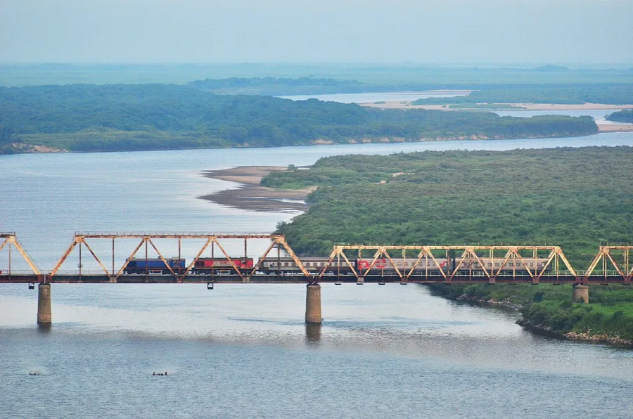
Longhu Pavilion provides a raised view of the river, railway crossing and neighbouring terrain. The historic Tu boundary marker adds a tangible element to the area's border history. Clear-weather views and access to individual sites vary, so approach Fangchuan as a managed Chinese-side landscape visit rather than an opportunity to cross into the neighbouring countries.
During the Sui and Tang dynasties Fangchuan lay on a maritime trade route linking China to Japan. Under Qing-era treaties with Russia, including the Treaty of Nerchinsk (尼布楚条约), Treaty of Aigun (瑷珲条约) and Treaty of Peking (北京条约), China lost its nearby Sea of Japan coastline, cutting off Fangchuan's sea access, and in 1938 the Battle of Lake Khasan (张鼓峰事件) broke out nearby between Japanese and Soviet forces. In 1886 the Qing official Wu Dacheng (吴大澄) negotiated with Russia and erected a granite boundary marker, the 'Tu' stone tablet (土字牌), 1.44 meters high.
Flooding of the Tumen River (图们江) in 1957 cut off Fangchuan's land route to the rest of China, turning it into an exclave that could be reached only through Soviet territory. A levee was built in 1990, and in 1992 an 888-meter, 8-meter-wide road on the levee restored Fangchuan's overland connection to mainland China.
In 2002 Fangchuan was designated a National Key Scenic Area (中国国家重点风景名胜区) with a planned area of 139 square kilometers and a 44.68-kilometer border line, set amid mountainous, hill-ringed terrain. Its closest point to the Sea of Japan lies under 3 kilometers away, about 16 kilometers from Russia's Posyet Port (波谢特港), and 120 kilometers from Vladivostok.
What to look for
- Longhu Pavilion's view over the lower Tumen and the adjoining border landscape.
- The Tu boundary marker and interpretation of the area's nineteenth-century boundary history.
Background & history
Fangchuan (Chinese: 防川; Korean: 방천) is a village in Yanbian Korean Autonomous Prefecture, Jilin, China. It is located near the tripoint where China's borders with North Korea and Russia intersect. Administratively, it is part of the town of Jingxin, itself a part of Hunchun, the easternmost city of Yanbian.
Excerpt from Wikipedia: Fangchuan · Wikipedia contributors · CC BY-SA 4.0. Selected introductory sentences; formatting simplified. Background information, not current visitor-service advice.
Location & getting there
Getting to Fangchuan
Travel from Hunchun towards Fangchuan Village in Jingxin Town. Use the scenic visitor entrance and its authorised internal connections; the narrow border-area approach is not a casual riverside walking route.
Combine your visit
Suggested order within this visit:
-
Longhu Pavilion
Understand the river and neighbouring terrain from the designated viewpoint.
-
Tu boundary-marker area
Add the historical border marker if the site is open on the authorised visitor route.
This sequence is an editorial suggestion based on the features described in the sources. Access to individual buildings or areas should be checked locally; no travel time or shared admission is implied.
Find Fangchuan
防川 · 延边朝鲜族自治州
The pin marks the area, not the entrance.
More places nearby
Approximate straight-line distances between map pins, not travel distances.
Yanji Dinosaur Museum 延吉恐龙博物馆
102 km awayYanji's dinosaur museum grew from fossil discoveries made at Longshan on Mao'er Mountain's southern slope. Its six Korean-style buildings divide the visit between a broad Dinosaur Planet introduction and the Dragon Rising in…
View guide →Head Mountain 延吉帽儿山
103 km awayMao'er Mountain takes its name from a hat-like profile above Yanji's southern outskirts. The approach moves from a forest boardwalk to a long stair climb, ending at a lookout over the city, river valleys and surrounding rice…
View guide →Korean Folk Customs Park of China 中国朝鲜族民俗园
103 km awayThe Korean Folk Customs Park in southern Yanji is a purpose-built cultural landscape arranged around traditional-style homes, food and performance spaces. It presents the appearance of a village while accommodating restaurants…
View guide →Sources & visit information
The sources below support the place-specific description and arrival information. Suggested combinations are editorial planning ideas; confirm current opening, entry arrangements and transport services for your date.
- Wikipedia: 防川村 ↗
- Jilin tourism department: Fangchuan Longhu Pavilion and border-history interpretation ↗
- Changchun university regional reference: Fangchuan pavilion and viewing geography ↗
Visitor information adapted and edited from Wikipedia contributors · CC BY-SA 4.0. Source revision 92237605.
Background paragraphs translated and condensed from Wikipedia contributors, "防川村", Chinese Wikipedia · CC BY-SA 4.0. Source revision 92237605.