


Get to know Jianping County
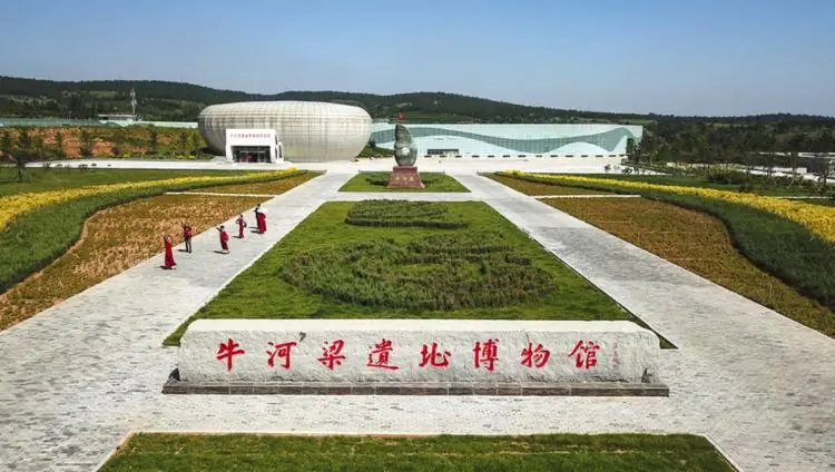
Photo adjustments
EXIF orientation normalized; resized without changing aspect ratio; converted to WebP. No subject edits.
- Administrative area
- County · 县
- Part of
- Chaoyang
- Chinese name
- 建平县
- Local areas
- County guide
Area & population
- Area in the source
- 4,838.00 km²
- Population · 2020 census
- 455,826
Source: cited geographic source, as of the dates shown.
History
The county was created in 1904 from land that had belonged to Jianchang (建昌, today's Lingyuan) and Pingquan (平泉), and its name joins the first characters of the two. People lived here as early as the Palaeolithic.
Niuheliang, on the border with Lingyuan, dates from 5,500 to 5,000 years ago, the late peak of the Hongshan culture (红山文化); excavations found large altars, a goddess temple, groups of stone cairn tombs, and many ritual jades and pots. Four sites in the county are national key protected sites: the Yan Great Wall (燕长城), Wulian Cheng (五连城), the Huizhou city site (惠州城) and the Mongol royal tombs (蒙古王陵).
What to see
The Great Wall of the Yan state was built after the general Qin Kai (秦开) drove back the Donghu (东胡) people, and after unification the Qin linked it with the walls of Qin and Zhao. It enters the county from the mouth of the Laoha River (老哈河) and runs 85 km through the Nulu'erhu mountains (努鲁儿虎山) in the north before crossing into Aohan Banner (敖汉旗) in Inner Mongolia; local people call it the "stone dragon" or "earth dragon". About 7,000 metres of wall, roughly 2 metres wide and 1 metre high, survive between Zhangjiaying (张家营) and Hamagounao (蛤蟆沟脑); the stretch on the north hill of Huajianggou village (化匠沟村) keeps its stonework best.
Huanghua Mountain (黄花山), 960 metres high on the north-western edge of the county town, is where, legend says, Mu Guiying (穆桂英) drilled her troops in the Song–Liao period; a reviewing platform, a horse post and a well on the mountain are still pointed out. Tianxiu Mountain (天秀山) forest park, at Xiaopingfang village (小平房村), covers 12 square kilometres, rises to 952 metres and is a 3A scenic area.
Climate and crafts
Dry air from the Mongolian Plateau makes the climate semi-arid: sunshine totals 2,850 to 2,950 hours a year, rainfall 450 to 580 mm, and springs and autumns are windy and prone to drought. Jianping paper-cutting (建平剪纸) is part of the Chinese paper-cut tradition on UNESCO's intangible heritage list, and the "Ten Kings Assembly" (十王会) wind music of sheng and guan pipes is on the national list.
Highlights
- Niuheliang Site 牛河梁遗址: Late Hongshan site of 5,500 to 5,000 years ago on the Jianping–Lingyuan border, with altars, a goddess temple and cairn tombs.
- Yan Great Wall 燕长城: Runs 85 km through the county; the best-preserved stonework is at Huajianggou village.
- Huanghua Mountain 黄花山: 960 m hill by the county town tied to the legend of Mu Guiying.
- Tianxiu Mountain 天秀山: 3A forest park of 12 square kilometres, rising to 952 m.
Sources for this guide
历史文化-建平县政府 · Jianping County People's Government
黄花山-精彩建平-建平县人民政府 · Jianping County People's Government
天秀山-精彩建平-建平县人民政府 · Jianping County People's Government
自然条件-建平县政府 · Jianping County People's Government
风物掌故-名胜掌故-朝阳县人民政府 · Chaoyang County People's Government
朝阳牛河梁红山文化概述-红山文化-朝阳市人民政府 · Chaoyang Municipal People's Government
Original English written from the listed sources and checked sentence by sentence against quoted extracts by a separate reviewer. Updated 2026-09-25.
Explore Jianping County
Core places to explore, with English and Chinese names.
Jianping County 建平县
Plan your visit
Getting there
Jianping County is about 70 km in a straight line from central Chaoyang. Search for 建平县 in a map app to find stations and your accommodation.
Where to stay →More in Chaoyang
Sources & geographic information
Administrative names and parent areas: Official geographic directory · Reference date 2026-09-06.
Map data © OpenStreetMap contributors. Pins mark approximate centres, not entrances or boundaries.