


Get to know Fengcheng
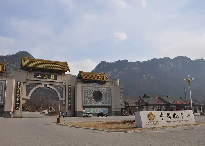
Photo adjustments
The exact downloaded source bytes are separately retained and hashed. Prepared JPEG is proportionally reduced to a maximum 720-pixel long edge; full frame retained, no subject alteration. Final website rendition: full frame retained, proportionally resized to at most 720 pixels and converted to WebP. No additional retouching or subject alteration. Card displays may crop the view.
- Administrative area
- County-level city · 县级市
- Part of
- Dandong
- Chinese name
- 凤城市
- Local areas
- County-level city guide
Area & population
- Area in the source
- 5,515.00 km²
- Population · 2017
- 580,000
Source: cited geographic source, as of the dates shown.
Setting and landscape
The north rises above 1,000 metres, with the highest point on Heshangmaozi Mountain (和尚帽子山) near Saima (赛马镇) at 1,208 metres; the land steps down through dissected hills towards the Yellow Sea coast in the south. Rivers drain to three systems, the Yalu (鸭绿江), the Taizi (太子河) and the Dayang (大洋河), and the main streams include the Ai River (爱河) and Cao River (草河). The Shenyang-Dandong high-speed line and the Shenyang-Dandong railway cross the city.
History
The Han set up Wuci County (武次县) here in 128 BC. In 404, when Goguryeo ruled Liaodong (辽东), it set up a prefecture based at a fortress on Fenghuang Mountain (凤凰山), today's Fenghuang Mountain Fortress. The Qing placed a garrison at Fenghuangcheng (凤凰城) in 1644. In 1914 the county was renamed Fengcheng because Hunan already had a Fenghuang County. It became Fengcheng Manchu Autonomous County in 1985 and a county-level city with State Council approval on 8 March 1994.
What to see
Fenghuang Mountain, 3 kilometres southeast of the city, is a national scenic area and an outlier of the Changbai Mountains (长白山), known in the past as Wugu Mountain (乌骨山). Chinese Wikipedia lists ten named views, among them the stone shelter and the flying cascades of the ravine.
The Fenghuang Mountain Fortress (凤凰山山城), also called Wugu Fortress (乌骨城), is described as the largest surviving Goguryeo hill fort on the right bank of the Yalu. Its walls run for about 16 kilometres, using Gaoli Mountain (高丽山) and Fenghuang Mountain as natural barriers. The State Council listed it among the fourth batch of national key cultural relics in November 1996. A rock platform inside the south gate bears the Ming inscription "Cuanyun Yan" (攒云岩, "cloud-gathering cliff"). Other sights in the city include Yulong Lake (玉龙湖), the Saima karst caves (赛马溶洞群) and the Dongtang hot springs (东汤温泉).
Highlights
- Fenghuang Mountain (Liaoning) 凤凰山: National scenic area 3 km southeast of the city, an outlier of the Changbai Mountains.
- Fenghuang Mountain Fortress 凤凰山山城: Goguryeo hill fort with about 16 km of walls, a national key cultural relic since 1996.
Sources for this guide
凤城市 - 维基百科,自由的百科全书 · Wikipedia (Chinese) · CC BY-SA 4.0
凤凰山山城 - 维基百科,自由的百科全书 · Wikipedia (Chinese) · CC BY-SA 4.0
凤凰山 (凤城市) - 维基百科,自由的百科全书 · Wikipedia (Chinese) · CC BY-SA 4.0
国务院关于公布第四批全国重点文物保护单位的通知 - 维基文库,自由的图书馆 · State Council of the PRC (notice Guofa [1996] No. 47, text on Wikisource)
Original English written from the listed sources and checked sentence by sentence against quoted extracts by a separate reviewer. Updated 2026-09-25.
Explore Fengcheng
Core places to explore, with English and Chinese names.
Places to explore around Fengcheng
Plan your visit
Getting there
Fengcheng is about 45 km in a straight line from central Dandong. Search for 凤城市 in a map app to find stations and your accommodation.
Where to stay →Build your route
Start with Fenghuang Mountain (Liaoning). The linked place guides have entrance and visit details.
Continue with Dandong →More in Dandong
Sources & geographic information
Administrative names and parent areas: Official geographic directory · Reference date 2026-09-06.
Some facts checked against 凤城市 — Wikipedia contributors, CC BY-SA 4.0.
Some facts checked against 凤凰山山城 — Wikipedia contributors, CC BY-SA 4.0.
Some facts checked against 凤凰山 (凤城市) — Wikipedia contributors, CC BY-SA 4.0.
Photo: Fenghuang Mountain (Liaoning) · Yoshi Canopus · Yoshi Canopus — Fenghuang_Mountain,_Fengcheng,_Dandong,_Liaoning.jpg — CC BY-SA 3.0 · CC BY-SA 3.0. The exact downloaded source bytes are separately retained and hashed. Prepared JPEG is proportionally reduced to a maximum 720-pixel long edge; full frame retained, no subject alteration. Final website rendition: full frame retained, proportionally resized to at most 720 pixels and converted to WebP. No additional retouching or subject alteration. Card displays may crop the view.

Map data © OpenStreetMap contributors. Pins mark approximate centres, not entrances or boundaries.