


Get to know Xingcheng
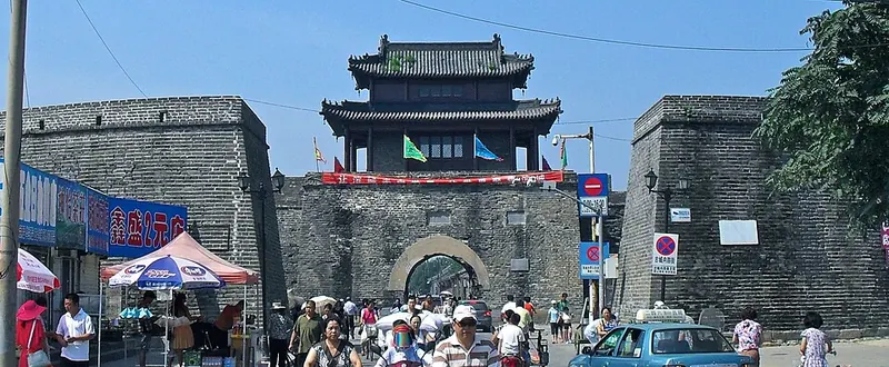
Photo adjustments
Full frame retained; proportionally resized and converted to WebP. No retouching or changes to the photographed subject. Card displays may crop the view.
- Administrative area
- County-level city · 县级市
- Part of
- Huludao
- Chinese name
- 兴城市
- Local areas
- County-level city guide
Area & population
- Area in the source
- 2,113.00 km²
- Population · 2020 census
- 552,180
Source: cited geographic source, as of the dates shown.
History
The name dates from 990, when the Liao dynasty moved people from Xingzhou (兴州) to what is now Juehua Island and set up a county called Xingcheng. In 1428 the Ming built a walled town here named Ningyuan (宁远) against raids by the Uriankhai Mongols (兀良哈). The city government calls it the strongest fort on the Ming defence line between Shanhai Pass (山海关) and Jinzhou (锦州). In 1626 the commander Yuan Chonghuan (袁崇焕), with fewer than 20,000 men, used 'red barbarian' cannon (红夷大炮) to repulse Nurhaci (努尔哈赤), who was badly wounded and died that August; Hong Taiji (皇太极) was beaten back again in 1627. The Xingcheng name was restored in 1914.
What to see
Xingcheng Old Town (兴城古城) is a national protected site covering the walls, four gates, the bell and drum tower, the stone arches and the Confucian temple. The inner wall runs for 3,274 m and stands 8.5 to 9.6 m high, with a half-moon barbican outside each gate and corner platforms that carried cannon. The city government calls the town the only Ming walled town surviving in northeast China. The bell and drum tower at the crossroads was rebuilt in 1777 and holds a drum of a single ox hide, 2.25 m across.
On South Street stand two stone arches that the last Ming emperor raised for the generals Zu Dashou (祖大寿) and Zu Dale (祖大乐), dated 1631 and 1638. On the fifteenth day of the first lunar month townspeople touch the stone lions, believing it cures illness in the same part of the body. The Confucian temple in the southeast corner was founded in 1430; its side halls hold exhibitions on Confucius's life and on the imperial examinations.
The seaside scenic area has 14 km of beaches in three bays, Xinghai, Gangkou and Bingjia, and a 1,670 m boardwalk from Longhuitou (龙回头) to Bingjia Bay. Juehua Island (觉华岛), which the city government lists as the largest island in Liaodong Bay, covers 13.5 km² and rises to 198.2 m. Under the Liao it was a Buddhist centre; the site of its Dalonggong Temple (大龙宫寺) keeps inscribed steles and foundations, and the temple was rebuilt in 2002.
Food and local products
The city lists prawns, razor clams, swimming crabs and jellyfish as its 'four great seafoods'. Hongyazi peanuts (红崖子花生) carry national geographical-indication protection; daikon radish, potatoes and apples are also grown. Dishes on Juehua Island include spicy ark clams stir-fried with bean paste and a fisherman-style stew of mixed fish.
Highlights
- Xingcheng Old Town 兴城古城: Ming walled town of Ningyuan, built 1428; a national protected site.
- Zu family stone arches 祖氏石坊: Two carved arches of 1631 and 1638 for the generals Zu Dashou and Zu Dale.
- Xingcheng Confucian Temple 兴城文庙: Founded in 1430 in the southeast corner of the old town.
- Juehua Island 觉华岛: Listed by the city government as the largest island in Liaodong Bay; site of the Liao-era Dalonggong Temple, rebuilt in 2002.
- Xingcheng seaside 兴城海滨: 14 km of beaches in three bays and a 1,670 m coastal boardwalk.
Sources for this guide
兴城概况_兴城市人民政府 · Xingcheng Municipal People's Government
古城景区_兴城市人民政府 · Xingcheng Municipal People's Government
觉华岛_兴城市人民政府 · Xingcheng Municipal People's Government
兴城海滨风景区_兴城市人民政府 · Xingcheng Municipal People's Government
Original English written from the listed sources and checked sentence by sentence against quoted extracts by a separate reviewer. Updated 2026-09-25.
Explore Xingcheng
Core places to explore, with English and Chinese names.
Places to explore around Xingcheng
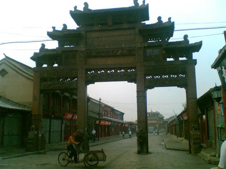 A street with a traditional memorial arch (paifang) in Xingcheng Old Town · 兴城古城内的牌坊街景 Source-recorded photograph date: 4 September 2007 (original upload date).
Xingcheng Old Town兴城古城
Xingcheng Old Town preserves the walled layout of Ningyuan, a Ming military town in the Liaoxi corridor.
Read the place guide →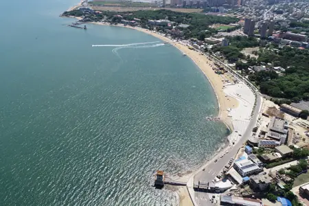 Xingcheng Seafront · 兴城海滨
Xingcheng Seafront兴城海滨
Xingcheng's seaside stretches across Xinghai, Gangkou and Bingjia bays on Liaodong Bay, combining sandy beaches with rocky viewpoints and wooded coastal paths.
Read the place guide → AI illustration · AI 示意图(仅供参考,非该地点实拍)
Juehua Island觉华岛
Juehua Island, also known as Juhua Island, lies off Xingcheng's southwestern coast and combines rocky island scenery with a long Buddhist cultural association.
Read the place guide →Plan your visit
Getting there
Xingcheng is about 15 km in a straight line from central Huludao. Search for 兴城市 in a map app to find stations and your accommodation.
Where to stay →Build your route
Xingcheng Old Town and Xingcheng Seafront are both listed here. The linked place guides have entrance and visit details.
Continue with Huludao →More in Huludao
Sources & geographic information
Administrative names and parent areas: Official geographic directory · Reference date 2026-09-06.
Photo: Xingcheng Old Town · 周李 · CC BY-SA 3.0. Full frame retained; proportionally resized and converted to WebP. No retouching or changes to the photographed subject. Card displays may crop the view.

Photo: Xingcheng Seafront · Source photographer · License not provided. EXIF orientation normalized; resized without changing aspect ratio; converted to WebP. No subject edits.
Map data © OpenStreetMap contributors. Pins mark approximate centres, not entrances or boundaries.