


Get to know Maqên County

Photo adjustments
Full frame retained; proportionally resized and converted to WebP. No retouching or changes to the photographed subject. Card displays may crop the view.
- Administrative area
- County · 县
- Part of
- Golog Tibetan Autonomous Prefecture
- Chinese name
- 玛沁县
- Local areas
- County guide
Area & population
- Area in the source
- 13,400.00 km²
- Population · 2020
- 58,117
- Administrative seat
- Dawo (Dawu)
Source: cited geographic source, as of the dates shown.
Setting and landscape
Maqên is high mountain country averaging about 4,300 metres, with the Jishi (积石山) range running through the whole county from north-west to south-east. The Yellow River enters from the west, loops around the Amne Machen massif through Gansu and Sichuan, and swings back north into Lajia town (拉加镇). Its tributaries here include the Youerqu (优尔曲), Dangqu (当曲), Gekequ (格科曲) and Qiemuqu (切木曲). Winters last eight or nine months, and only the Yellow River stretch around Lajia has a frost-free season. Forests of Qinghai spruce and Qilian juniper grow in three areas: the Qiemuqu valley, around Yangyu (洋玉) along the south bank of the Yellow River, and the Deke River (德柯河) valley. Wild yaks, wild asses and white-lipped deer live across the county.
What to see
Amne Machen is a national geopark, and the county government ranks it with Mount Kailash, the Meili Snow Mountains and Gadu Jowo (尕朵觉吾) as one of the four sacred mountains of the Tibetan regions. The main peak, Machen Kangri (玛卿岗日), reaches 6,282 metres, and the Halong Glacier (哈龙冰川) falls 1,800 metres and is described as the longest and largest glacier in the Yellow River basin. The myths of Amne Machen are on the national intangible-heritage list.
Lajia Monastery (拉加寺), a Gelug house more than 240 years old, stands on the north bank of the Yellow River below Ani Qungong hill (阿尼群贡), whose name means 'the roc spreading its wings'; it faces west over the river and is a national key cultural relics protection unit. Lari Monastery (喇日寺) in Dawu town (大武镇), the county seat, is also Gelug and has colleges of medicine, tantra and logic, a debating hall and a Padmasambhava hall. The ruins of the Zimu walled town (子木山城址) are a provincial-level protected site.
Crafts and local products
Lajia Tibetan boots (拉加藏靴) are on Qinghai's provincial intangible-heritage list. Snow lotus, caterpillar fungus, astragalus, rhodiola and fritillary are among the main wild medicinal plants of the county.
Getting oriented
The county town is 420 kilometres from Xining (西宁) and 5.5 kilometres from Maqin Airport (玛沁机场). Maqên borders Maqu (玛曲) in Gansu to the east, Henan Mongol Autonomous County (河南蒙古族自治县) to the north-east, Tongde (同德) and Xinghai (兴海) to the north, Madoi (玛多) and Darlag (达日) to the west and Gadê (甘德) to the south.
Highlights
- Amne Machen 阿尼玛卿雪山: National geopark; main peak Machen Kangri, 6,282 m; one of the four sacred mountains of the Tibetan regions.
- Halong Glacier 哈龙冰川: Falls 1,800 m; described as the longest and largest glacier in the Yellow River basin.
- Lajia Monastery 拉加寺: Gelug monastery over 240 years old above the Yellow River; national key cultural relics protection unit.
- Lari Monastery 喇日寺: Gelug monastery in Dawu with colleges of medicine, tantra and logic.
- Lajia Tibetan boots 拉加藏靴: Provincial intangible heritage.
Sources for this guide
玛沁县 - 维基百科,自由的百科全书 · Chinese Wikipedia · CC BY-SA 4.0
县情简介(文化旅游) · Maqên County People's Government
县情简介(县情概况) · Maqên County People's Government
县情简介(概况) · Maqên County People's Government
Original English written from the listed sources and checked sentence by sentence against quoted extracts by a separate reviewer. Updated 2026-09-26.
Explore Maqên County
Core places to explore, with English and Chinese names.
Places to explore around Maqên County
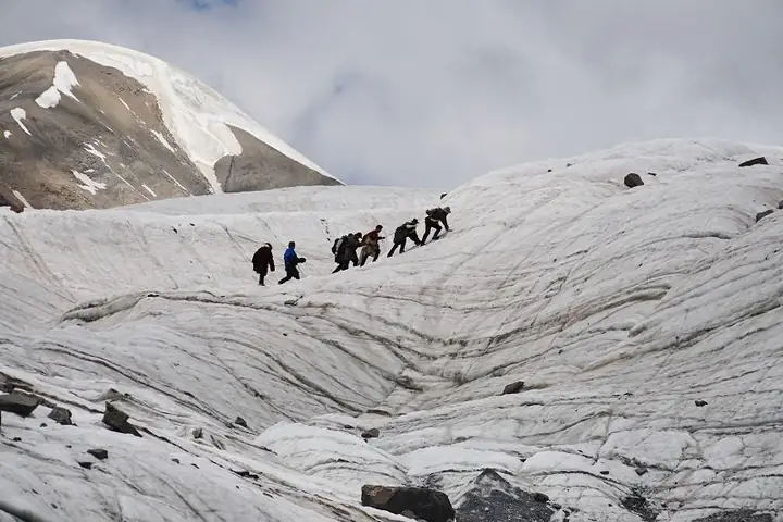 Amne Machin Snow Mountain Roadside Viewpoint ·
 Plan your visit
Getting there
Maqên County is about 95 km in a straight line from central Golog Tibetan Autonomous Prefecture. Search for 玛沁县 in a map app to find stations and your accommodation.
Where to stay →Build your route
Start with Amne Machin Snow Mountain Roadside Viewpoint. The linked place guides have entrance and visit details.
Continue with Golog Tibetan Autonomous Prefecture →More in Golog Tibetan Autonomous Prefecture
Sources & geographic information
Administrative names and parent areas: Official geographic directory · Reference date 2026-09-06.
Some facts checked against 玛沁县 — Wikipedia contributors, CC BY-SA 4.0.
Photo: Amne Machin Snow Mountain Roadside Viewpoint · Source photographer · License not provided. EXIF orientation normalized; resized without changing aspect ratio; converted to WebP. No subject edits.
Map data © OpenStreetMap contributors. Pins mark approximate centres, not entrances or boundaries.