


Get to know Huangdao District
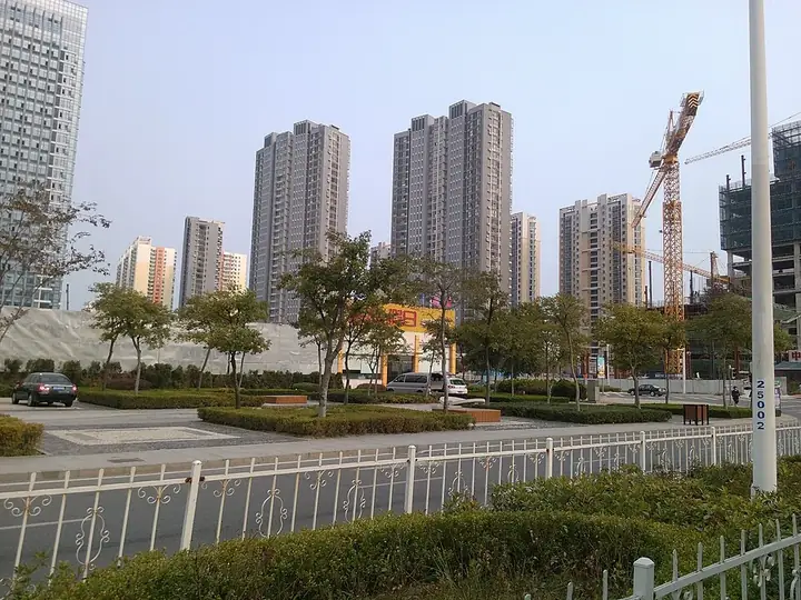
Photo adjustments
Full frame retained; resized proportionally to a maximum dimension of 960 pixels and converted to WebP quality 88. No crop, retouch, generated elements, or subject alteration. Final website rendition: full frame retained, proportionally resized to at most 720 pixels and converted to WebP. No additional retouching or subject alteration. Card displays may crop the view.
- Administrative area
- District · 市辖区
- Part of
- Qingdao
- Chinese name
- 黄岛区
- Local areas
- District guide
Area & population
- Area in the source
- 2,220.10 km²
- Population · 2019
- 1,608,200
- Administrative seat
- Yinzhu Subdistrict (隐珠街道)
Source: cited geographic source, as of the dates shown.
Setting and landscape
The district takes its name from Huang Island (黄岛), once an island of about 5.33 square kilometres in Jiaozhou Bay. Land reclamation for the Huangdao oil port began in 1980 and has since joined it to the mainland. A 1931 gazetteer explains the name: the island lay north of Huang'an hill, its salty soil looked yellow, and at high tide it was cut off by water.
The district has 309 kilometres of coastline. To the south it faces Lianyungang (连云港) in Jiangsu across Haizhou Bay (海州湾). Offshore islands include Lingshan Island (灵山岛) and Zhaitang Island (斋堂岛).
What to see
Langyatai (琅琊台) is an ancient site on Langyatai hill in Langya town (琅琊镇), listed by Shandong province in 1992 and as a national key cultural relic protection site in 2013. The resort area around it includes Longwan bathing beach (龙湾海水浴场), and the site of the ancient Langya port lies nearby. A suggested route through the scenic area passes a hall to Xu Fu (徐福殿) and the Langya stone inscription (琅琊刻石).
Dazhu Mountain (大珠山) runs more than 20 kilometres along the southeastern coast, its main peak reaching 486 metres. A Qianlong-era gazetteer of Jiaozhou called it the finest spot in the prefecture. It holds Buddhist cave carvings from the Sui and Tang and the Shimen Temple (石门寺), rebuilt in the Jin dynasty's Dading era. Wild azaleas fill three valleys on its eastern slopes from March to May, a customary spring outing for people from Qingdao.
History
Huangdao became a Qingdao district in 1979, formed from three communes split off Jiaonan County (胶南县). In December 2012 it merged with the former Jiaonan city, and in June 2014 the State Council approved the West Coast New Area over the same ground. The district history office promotes the area for film and beer, naming the Oriental Movie Metropolis (东方影都) studios and the Qingdao International Beer Festival (青岛国际啤酒节), which it calls the largest beer festival in the world.
Getting oriented
The Jiaozhou Bay Tunnel and the Jiaozhou Bay Bridge, both opened in June 2011, link the district to central Qingdao, and Metro Line 1 has crossed the bay since 2021. Qingdao West railway station is in the western urban area. Three of the main harbour areas of Qingdao port, including Qianwan (前湾) and Dongjiakou (董家口), are in the district.
Highlights
- Langyatai 琅琊台: Ancient site on Langyatai hill in Langya town, a national key cultural relic protection site since 2013.
- Dazhu Mountain 大珠山: Coastal range rising to 486 metres, with Sui and Tang Buddhist cave carvings and wild azaleas that flower from March to May.
- Shimen Temple 石门寺: Temple on Dazhu Mountain rebuilt in the Dading era of the Jin dynasty.
- Qingdao International Beer Festival 青岛国际啤酒节: Called the largest beer festival in the world by the district history office, which lists beer among the area's four calling cards.
Sources for this guide
黄岛区 - 维基百科,自由的百科全书 · Wikipedia (Chinese) · CC BY-SA 4.0
青岛西海岸新区简介 · Local History Research Centre of the Qingdao West Coast New Area (Huangdao District)
琅琊台旅游度假区 · Local History Research Centre of the Qingdao West Coast New Area (Huangdao District)
大珠山风景区 · Local History Research Centre of the Qingdao West Coast New Area (Huangdao District)
琅琊台 - 维基百科,自由的百科全书 · Wikipedia (Chinese) · CC BY-SA 4.0
Original English written from the listed sources and checked sentence by sentence against quoted extracts by a separate reviewer. Updated 2026-09-25.
Explore Huangdao District
Core places to explore, with English and Chinese names.
Places to explore around Huangdao District
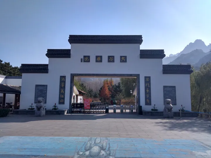 The north gate of Dazhu Mountain Scenic Area in Huangdao District, Qingdao, with the mountain behind · 青岛黄岛区大珠山风景区北门,背景为大珠山 Source-recorded photograph date: 9 November 2018 (according to Exif data).
Dazhu Mountain大珠山
Coastal mountain in Qingdao's Huangdao District with Shimen Temple, Sui–Tang grottoes and three valleys of wild azaleas that bloom from April.
Read the place guide →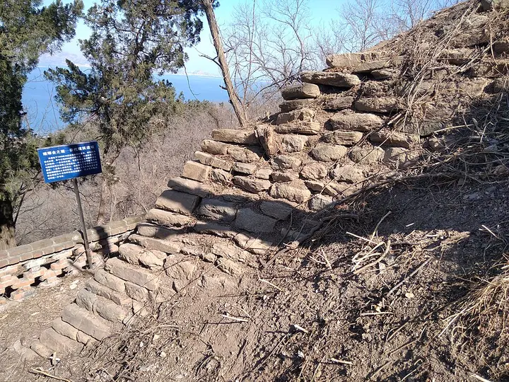 Qin-period building remains at Langyatai, Qingdao · 青岛琅琊台秦代建筑遗址 Photograph date recorded by the source: 9 February 2025, 13:17:24.
Langyatai Platform琅琊台
Langyatai is a coastal hill associated with Qin imperial journeys, above the shore of Huangdao. Archaeology has revealed a substantial Qin building complex subsequently repaired in the Han period, including terraces and an…
Read the place guide → AI illustration · AI 示意图(仅供参考,非该地点实拍)
Golden Beach金沙滩
Jinshatan (金沙滩), the Golden Sand Beach, is a crescent of fine golden sand in Huangdao District, Qingdao, on the south-eastern edge of the city's economic and technological development zone. It runs east to west for more than 3,500 metres and is about 300 metres wide.
Read the place guide →Plan your visit
Getting there
Huangdao District is about 35 km in a straight line from central Qingdao. Search for 黄岛区 in a map app to find stations and your accommodation.
Where to stay →Build your route
Dazhu Mountain and Langyatai Platform are both listed here. The linked place guides have entrance and visit details.
Continue with Qingdao →More in Qingdao
Sources & geographic information
Administrative names and parent areas: Official geographic directory · Reference date 2026-09-06.
Some facts checked against 黄岛区 — Wikipedia contributors, CC BY-SA 4.0.
Some facts checked against 琅琊台 — Wikipedia contributors, CC BY-SA 4.0.
Photo: Dazhu Mountain · Sprt98 · CC BY-SA 4.0. Full frame retained; proportionally resized and converted to WebP. No retouching or changes to the photographed subject. Card displays may crop the view.

Photo: Langyatai Platform · Sprt98 · Sprt98 — 琅琊台景区——秦代建筑遗址.jpg — CC BY-SA 4.0 · CC BY-SA 4.0. Full frame retained; proportionally resized and converted to WebP. No retouching or changes to the photographed subject. Card displays may crop the view.

Map data © OpenStreetMap contributors. Pins mark approximate centres, not entrances or boundaries.