


Get to know Donggang District
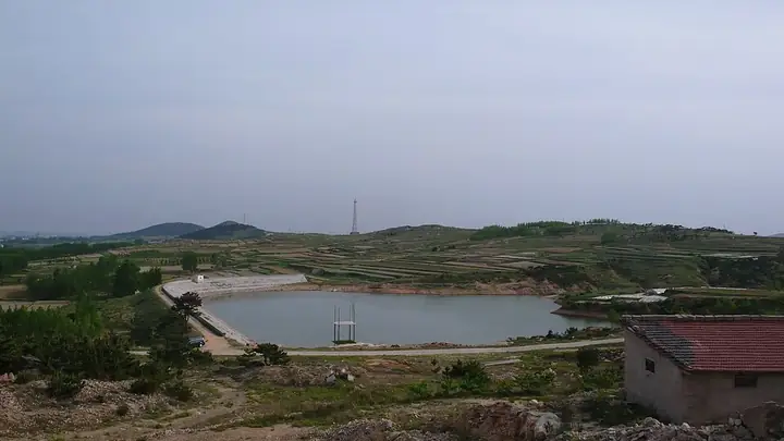
Photo adjustments
Full frame retained; resized proportionally to a maximum dimension of 960 pixels and converted to WebP quality 88. No crop, retouch, generated elements, or subject alteration. Final website rendition: full frame retained, proportionally resized to at most 720 pixels and converted to WebP. No additional retouching or subject alteration. Card displays may crop the view.
- Administrative area
- District · 市辖区
- Part of
- Rizhao
- Chinese name
- 东港区
- Local areas
- District guide
Area & population
- Population · 2019
- 751,500
Source: cited geographic source, as of the dates shown.
Setting and landscape
The district government describes a warm-temperate, semi-humid monsoon climate and a coast known for its blue sky, sea and golden sand, and notes that Donggang is rich in fresh water, unusually for northern China. Sea cucumber, abalone and the clam known as xishishe (西施舌) are among more than 60 prized seafoods produced here. Donggang also grows tea and blueberries and calls itself the home of northern green tea and China's blueberry country.
What to see
Wanpingkou (万平口) is a beach with 5 kilometres of Yellow Sea shoreline. Merchant ships already anchored here under the Yuan dynasty; a tide barrage and sluice gates were built in 1959, and after rebuilding in 2016 the area has an ecological square, a Taigong Island square and a string of themed beaches. It became a national 4A scenic area in 2009.
Rizhao Seaside National Forest Park (日照海滨国家森林公园) has 7 kilometres of coast with sandy beaches. It began in February 1960 as the Dashawa tree farm (大沙洼林场), a planted coastal shelter belt, became a national forest park in 1992 and took its present name in 2002.
The district government lists five national 4A scenic areas: Wanpingkou, Longmengu (龙门崮), Liujiawan (刘家湾), the ocean park and Mount Tiantai (天台山). Donggang also has the Olympic Water Park, where the China Water Sports Games and a sailing world championship have been held.
History and culture
The district government calls Donggang an important cradle of the Longshan culture and says its black pottery is more than 4,000 years old. The Neolithic Liangchengzhen site (两城镇遗址) in Liangcheng was the largest of more than 20 sites found in southeast Shandong in the 1930s; it was excavated in 1936, again by a joint team of Shandong University, Yale University and the Field Museum from 1998 to 2001, and listed as a national key site in 2006. Donggang is also counted among China's three main centres of peasant painting, and it is the home of the strategist Jiang Shang (姜尚) and of Liu Xie (刘勰), author of The Literary Mind and the Carving of Dragons (文心雕龙). The ancestral home of the physicist Samuel Ting (丁肇中) is here too.
Highlights
- Wanpingkou 万平口: 5-kilometre Yellow Sea beach, a national 4A scenic area since 2009.
- Rizhao Seaside National Forest Park 日照海滨国家森林公园: Coastal shelter belt planted from 1960, with 7 kilometres of coast.
- Liangchengzhen site 两城镇遗址: Longshan-culture Neolithic site, a national key site since 2006.
- Xishishe clam 西施舌: Named by the district government among Donggang's prized seafoods.
Sources for this guide
东港区 - 维基百科,自由的百科全书 · Wikipedia (Chinese) · CC BY-SA 4.0
日照市东港区人民政府 东港概况 · Donggang District People's Government, Rizhao
万平口 - 维基百科,自由的百科全书 · Wikipedia (Chinese) · CC BY-SA 4.0
两城镇遗址 - 维基百科,自由的百科全书 · Wikipedia (Chinese) · CC BY-SA 4.0
日照海滨国家森林公园 - 维基百科,自由的百科全书 · Wikipedia (Chinese) · CC BY-SA 4.0
Original English written from the listed sources and checked sentence by sentence against quoted extracts by a separate reviewer. Updated 2026-09-25.
Explore Donggang District
Core places to explore, with English and Chinese names.
Places to explore around Donggang District
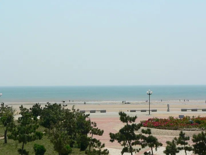 The seaside plaza and pine-fringed beach of Rizhao Seaside National Forest Park, Donggang District · 日照海滨国家森林公园海滨广场,东港区 Source-recorded photograph date: Taken on 22 May 2005.
Rizhao Seaside National Forest Park日照海滨国家森林公园
Coastal pine and dawn redwood forest in Rizhao, planted from 1960 on salty sand flats, with a beach, deer park and pioneers' exhibition hall.
Read the place guide →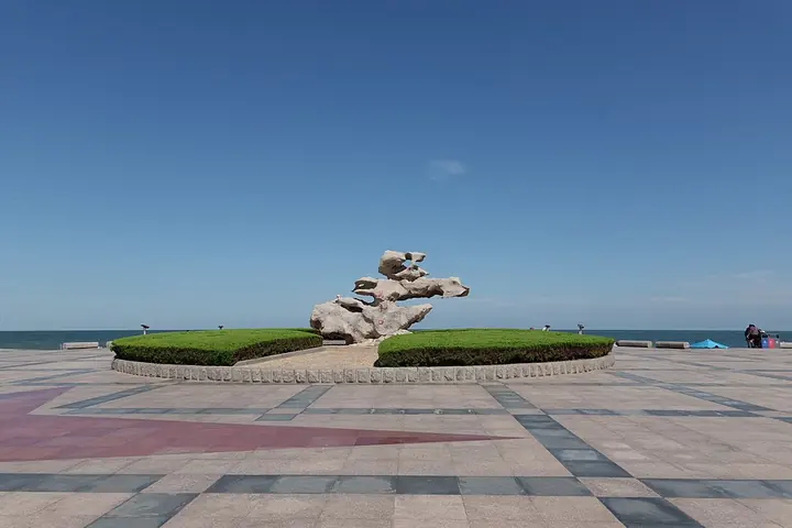 The seaside plaza at Wanpingkou Marine Park, photographed in 2022 · 万平口 Photograph date recorded by the source: 20 August 2022, 14:38:34.
Wanpingkou万平口
Wanpingkou is a long public beach landscape on Rizhao’s Yellow Sea coast, arranged around squares, planted areas and different stretches of sand. The main Ecological Square anchors the southern visitor area, while Zhulang Bridge…
Read the place guide →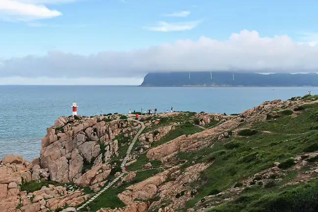 Lighthouse Scenic Area · 灯塔风景区
Lighthouse Scenic Area灯塔风景区
The Dengta Scenic Area (灯塔风景区), also published as Dengta Square, is the reef-bound stretch of Rizhao’s seafront in Donggang District, Shandong, named after the lighthouse that stands on its shore.
Read the place guide →Plan your visit
Getting there
Donggang District is about 6 km in a straight line from central Rizhao. Search for 东港区 in a map app to find stations and your accommodation.
Where to stay →Build your route
Rizhao Seaside National Forest Park and Wanpingkou are both listed here. The linked place guides have entrance and visit details.
Continue with Rizhao →More in Rizhao
Sources & geographic information
Administrative names and parent areas: Official geographic directory · Reference date 2026-09-06.
Some facts checked against 东港区 — Wikipedia contributors, CC BY-SA 4.0.
Some facts checked against 万平口 — Wikipedia contributors, CC BY-SA 4.0.
Some facts checked against 两城镇遗址 — Wikipedia contributors, CC BY-SA 4.0.
Some facts checked against 日照海滨国家森林公园 — Wikipedia contributors, CC BY-SA 4.0.
Photo: Rizhao Seaside National Forest Park · Jd Shi · CC BY-SA 3.0. Full frame retained; proportionally resized and converted to WebP. No retouching or changes to the photographed subject. Card displays may crop the view.

Photo: Wanpingkou · Iswzo · CC BY-SA 4.0. Full frame retained; proportionally resized and converted to WebP. No retouching or changes to the photographed subject. Card displays may crop the view.

Photo: Lighthouse Scenic Area · 颐园居 · CC BY-SA 4.0. EXIF orientation normalized; resized without changing aspect ratio; converted to WebP. No subject edits.

Map data © OpenStreetMap contributors. Pins mark approximate centres, not entrances or boundaries.