


Get to know Lanshan District
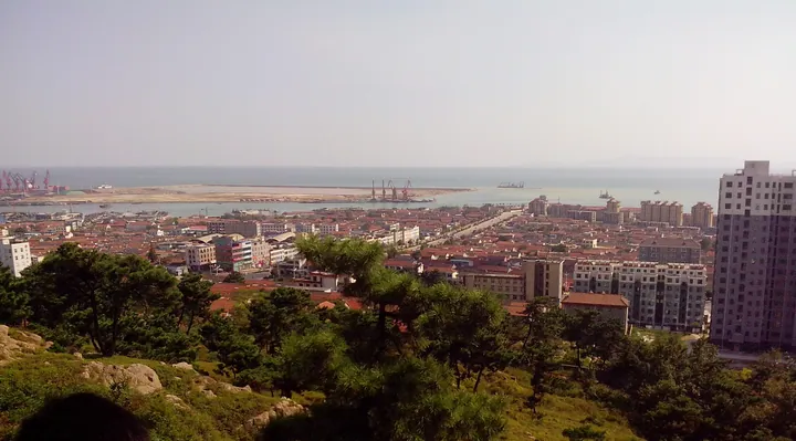
Photo adjustments
Full frame retained; proportionally resized and converted to WebP. No retouching or changes to the photographed subject. Card displays may crop the view.
- Administrative area
- District · 市辖区
- Part of
- Rizhao
- Chinese name
- 岚山区
- Local areas
- District guide
Area & population
- Area in the source
- 646.00 km²
- Population · 2019
- 409,700
Source: cited geographic source, as of the dates shown.
Setting and landscape
The land rises to the north and west; the district has hills at its back and faces the sea. Its 39.56 km coastline runs from the waters off Donghu Sancun (东湖三村) in Hushan (虎山) south to the mouth of the Xiuzhen River (绣针河), which follows the provincial boundary before entering the Yellow Sea. The other main rivers are the Jufeng (巨峰河), Xun (浔河), Longwang (龙王河) and Chuanzi (川子河).
Offshore to the southeast lie the Qiansan Islands (前三岛): Pingshan (平山岛), Dashan (达山岛) and Cheniushan (车牛山岛). More than 100 bird species have been recorded on them, and a bird reserve has been set up.
History
The Yaowangcheng site (尧王城遗址), around Nanxinzhuangzi (南辛庄子) in Gaoxing town (高兴镇), is mainly a Neolithic Longshan culture site of about 520,000 square metres and became a national protected site in May 2006; its finest pottery is thin, hard, glossy black eggshell ware. Beiguo town (碑廓镇) is honoured as the home of Xiang Tuo (项橐), the child prodigy said to have set Confucius three hard questions.
In 1384 Tang He (汤和), the Ming Duke of Xin, built the Andongwei (安东卫) garrison town on the coast against Japanese pirates. It was counted with Tianjin and Weihai among the four famous garrisons of the northern coast, and was folded into Rizhao County in 1742. Lanshan became a district of Rizhao in September 2004.
What to see
The Sea Stele (海上碑) is a large rock in Lanshan fishing harbour, not far offshore, that disappears at high tide and reappears at low tide. It carries five inscriptions: two by Su Jing (苏京) of the late Ming, two by his contemporary Wang Duo (王铎), and one by Yan Yuxiu (阎毓秀) of the early Qing.
Food and local products
Lanshan green tea dates from 1966, when tea from the south was first grown successfully on the north hill at Andongwei; the district describes the leaves as plump and tender. Its shellfish include xishishe (西施舌, "Xi Shi's tongue"), a flat, tongue-shaped clam with a red tip and tender, smooth flesh.
Highlights
- Yaowangcheng site 尧王城遗址: Longshan culture settlement in Gaoxing town, national protected site since 2006.
- Sea Stele 海上碑: Tidal rock in Lanshan fishing harbour with five Ming and Qing inscriptions.
- Qiansan Islands 前三岛: Three islands to the southeast with more than 100 recorded bird species and a bird reserve.
- Xishishe clam 西施舌: Flat, tongue-shaped local clam with a red tip and tender flesh.
Sources for this guide
岚山概况 (Lanshan overview) · Lanshan District People's Government, Rizhao
历史沿革 (Lanshan history) · Lanshan District People's Government, Rizhao
环境资源 (Lanshan environment and resources) · Lanshan District People's Government, Rizhao
海上碑及作者 (The Sea Stele and its authors) · Lanshan District People's Government, Rizhao
前三岛 (Qiansan Islands) · Lanshan District People's Government, Rizhao
尧王城遗址 (Yaowangcheng site) · Lanshan District People's Government, Rizhao
西施舌 (Xishishe clam) · Lanshan District People's Government, Rizhao
Original English written from the listed sources and checked sentence by sentence against quoted extracts by a separate reviewer. Updated 2026-09-23.
Explore Lanshan District
Core places to explore, with English and Chinese names.
Lanshan District 岚山区
Plan your visit
Getting there
Lanshan District is about 40 km in a straight line from central Rizhao. Search for 岚山区 in a map app to find stations and your accommodation.
Where to stay →More in Rizhao
Sources & geographic information
Administrative names and parent areas: Official geographic directory · Reference date 2026-09-06.
Map data © OpenStreetMap contributors. Pins mark approximate centres, not entrances or boundaries.