


Get to know Changyi
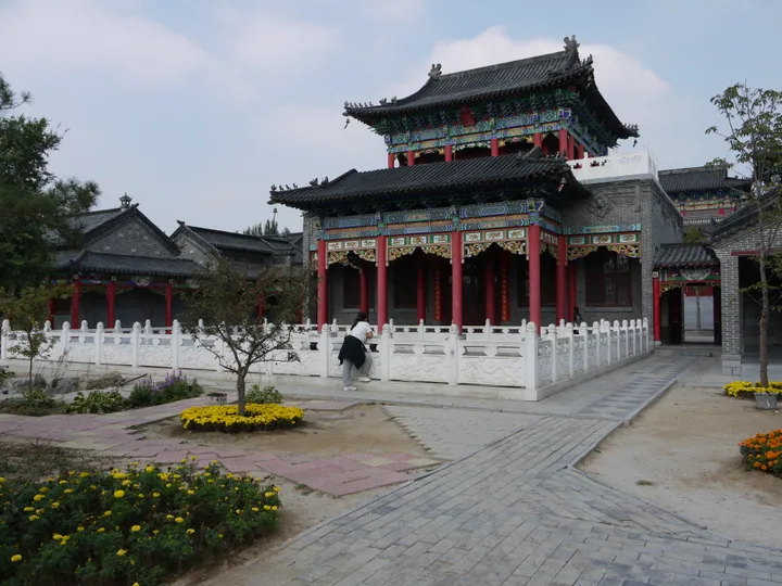
Photo adjustments
Full frame retained; proportionally resized and converted to WebP. No retouching or changes to the photographed subject. Card displays may crop the view.
- Administrative area
- County-level city · 县级市
- Part of
- Weifang
- Chinese name
- 昌邑市
- Local areas
- County-level city guide
Area & population
- Area in the source
- 1,578.70 km²
- Population · 2018
- 618,400
Source: cited geographic source, as of the dates shown.
Setting and landscape
The land drops gradually from low hills in the south, including Bolu Mountain (博陆山), through a central plain to coastal flats in the north, where salt works and fish farms are common. The Wei is the main river, and the Jiaolai River (胶莱河) forms the eastern boundary with Laizhou and Pingdu. The coastline is 58.38 kilometres long, and the north holds oil, natural gas and underground brine.
History
The area was known in antiquity as Ziyi (鄑邑) and Duchang (都昌). After conquering Qi in 221 BC, the Qin set up Duchang County here; Changyi County dates from 962 under the Song, and it became a county-level city on 10 June 1994. The Jiang Clan Ancestral Hall (姜氏祠堂), off Jiefang Road in the old town, was built from 1817 with clan donations; its brick-and-timber halls with grey tile roofs cover about 900 square metres, and it has been a provincial protected site since 2007. One clan member, Shizhen (士祯), entered the Qing banner system, changed his surname to Li and became governor of Jiangxi and Guangdong; his son Xu (煦) served 32 years as imperial textile commissioner in Suzhou.
What to see
North of Longchi town (龙池镇), the Longxiang Shuiyun Millennium Village area (龙乡水韵·千年古村文化旅游区) centres on the Qing-dynasty houses of Qixi Village (齐西村) and takes in a martyrs' shrine and an anti-Japanese war memorial hall. The Changyi County Anti-Japanese Martyrs' Shrine (昌邑县抗日殉国烈士祠) is a national key protected site. The Green Expo Park (绿博园), founded in 2003, hosts the North China greening nursery fair every 19 September and is rated 4A, and the Weishui wetland park (潍水风情湿地公园) is laid out in east-bank and west-bank sections.
Food and local products
Nanpang (南逄) is known as the "ginger village"; the city government traces Nanpang ginger (南逄大姜) to Wuta Village (伍塔村) on the west bank of the Wei, founded in the early Ming, and describes the roots as plump and bright yellow with a sweet, pungent aroma. Changyi silk, Changyi prawns and Changyi swimming crab are national geographical-indication products. Changyi paper-cutting has a written history of more than 400 years and includes window flowers, lantern cuts and wedding cuts; in the folk paper-cuts of Longchi every line must join the next.
Getting oriented
The Qingdao–Jinan railway, the Qingdao–Yinchuan and Rongcheng–Weifang expressways and National Highways 206 and 309 cross the city from east to west, and Changyi Station is where the Weifang–Laixi and Weifang–Yantai high-speed lines meet. Weifang airport is 30 kilometres away.
Highlights
- Jiang Clan Ancestral Hall 姜氏祠堂: Clan hall in the old town built from 1817; provincial protected site since 2007.
- Longxiang Shuiyun Millennium Village area 龙乡水韵·千年古村文化旅游区: Qing-dynasty houses of Qixi Village north of Longchi town.
- Green Expo Park 绿博园: 4A park founded in 2003 that hosts the annual greening nursery fair on 19 September.
- Nanpang ginger 南逄大姜: Grown along the west bank of the Wei, traced to Wuta Village.
- Changyi paper-cutting 昌邑剪纸: Longchi folk paper-cuts with over 400 years of written record.
Sources for this guide
昌邑市 - 维基百科,自由的百科全书 · Wikipedia (Chinese) · CC BY-SA 4.0
自然地理 — 昌邑市人民政府 · Changyi Municipal People's Government
区位交通 — 昌邑市人民政府 · Changyi Municipal People's Government
昌邑姜氏祠堂 — 昌邑市人民政府 · Changyi Municipal People's Government
龙乡水韵·千年古村文化旅游区 — 昌邑市人民政府 · Changyi Municipal People's Government
南逄大姜 — 昌邑市人民政府 · Changyi Municipal People's Government
昌邑剪纸 — 昌邑市人民政府 · Changyi Municipal People's Government
Original English written from the listed sources and checked sentence by sentence against quoted extracts by a separate reviewer. Updated 2026-09-23.
Explore Changyi
Core places to explore, with English and Chinese names.
Plan your visit
Getting there
Changyi is about 30 km in a straight line from central Weifang. Search for 昌邑市 in a map app to find stations and your accommodation.
Where to stay →More in Weifang
Sources & geographic information
Administrative names and parent areas: Official geographic directory · Reference date 2026-09-06.
Some facts checked against 昌邑市 — Wikipedia contributors, CC BY-SA 4.0.
Map data © OpenStreetMap contributors. Pins mark approximate centres, not entrances or boundaries.