


Get to know Qinshui County

- Administrative area
- County · 县
- Part of
- Jincheng
- Chinese name
- 沁水县
- Local areas
- County guide
Setting and landscape
The county is about 150 km long from east to west and 55 km wide. Mid-height mountains cover 40 per cent of it, low hills 50 per cent and river flats 10 per cent. The Qin River, a direct tributary of the Yellow River, runs 82 km through the towns of Zhengzhuang (郑庄), Duanshi (端氏) and Jiafeng (嘉峰); Zhangfeng Reservoir (张峰水库) in Zhengzhuang is the first large water project on its main stream.
History
Finds at the Xiachuan site (下川遗址) show people living here 23,000 to 16,000 years ago. In 376 BC, when Zhao, Wei and Han divided the state of Jin, the Jin ruler was moved to Duanshi, at today's Xicheng village (西城村) 22 km east of the county town, which the county government calls the last capital of Jin. Yongning County was renamed Qinshui in 598 and moved to the present town, and Duanshi County was merged into it in 1266.
What to see
The Liu Family Residences (柳氏民居) in Xiwenxing village (西文兴村) were begun in 1406 by descendants of the Tang writer Liu Zongyuan (柳宗元) as a mansion of thirteen courtyards. The county government lists carved inscriptions and calligraphy attributed to Zhu Xi (朱熹), Wang Yangming (王阳明) and Wen Zhengming (文征明); the residences are a major national heritage site.
Lishan (历山), 50 km southwest of the county town, has been a national nature reserve and national forest park since 1988. Its summit, Shunwangping, is the highest point of the Zhongtiao Mountains and of southern Shanxi, and legend says the sage-king Shun farmed here. The county government names its primeval forest, karst caves, alpine meadow and gorges. Xiangyu Castle (湘峪古堡) and the old buildings of Guobi (郭壁) and Douzhuang (窦庄) are also national heritage sites, and the main section of Taihang Honggu National Forest Park (太行洪谷), set up in 2017, is at Nanyang village (南阳村), home and retreat of the Later Liang (后梁) painter Jing Hao (荆浩).
Food and local products
Mutton Li Gezhua (羊肉李圪抓) is a pan-fried mutton pastry; local legend credits a shepherd named Li who stretched the dough of his mutton buns thin with oiled hands and fried them on a griddle. The county government calls Qinshui the largest beekeeping county in Shanxi and a main source of vitex and black locust honey, and its forsythia (连翘) was sent to the Qing court as a tribute medicine.
Highlights
- Lishan Shunwangping 历山舜王坪: 2,358 m summit of the Zhongtiao range in a national nature reserve since 1988.
- Liu Family Residences 柳氏民居: Thirteen-courtyard mansion begun in 1406 by descendants of Liu Zongyuan; major national heritage site.
- Xiangyu Castle 湘峪古堡: Fortified village listed as a major national heritage site.
- Mutton Li Gezhua 羊肉李圪抓: Thin-skinned mutton pastry fried on a griddle.
Sources for this guide
沁水县 · Chinese Wikipedia · CC BY-SA 4.0
沁水概况 · Qinshui County People's Government
柳氏民居景区 · Qinshui County People's Government
沁水历山国家自然保护级风景区 · Qinshui County People's Government
李圪抓 · Qinshui County People's Government
Original English written from the listed sources and checked sentence by sentence against quoted extracts by a separate reviewer. Updated 2026-09-26.
Explore Qinshui County
Core places to explore, with English and Chinese names.
Places to explore around Qinshui County
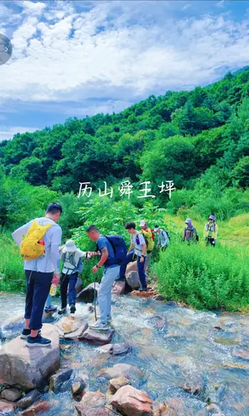 Mount Lishan Shunwangping · 历山舜王坪
Mount Lishan Shunwangping历山舜王坪
Mount Lishan Shunwangping (历山舜王坪) is the 2,358-metre main summit of Lishan, with open highland meadows above the surrounding wooded mountains.
Read the place guide →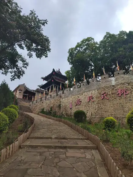 Liu Family Residences · 柳氏民居
Liu Family Residences柳氏民居
Liu Family Residences (柳氏民居) is a group of historic Liu family courtyard houses in Xiwenxing village, in Qinshui County's Tuwo area.
Read the place guide →Plan your visit
Getting there
Qinshui County is about 65 km in a straight line from central Jincheng. Search for 沁水县 in a map app to find stations and your accommodation.
Where to stay →Build your route
Mount Lishan Shunwangping and Liu Family Residences are both listed here. The linked place guides have entrance and visit details.
Continue with Jincheng →More in Jincheng
Sources & geographic information
Administrative names and parent areas: Official geographic directory · Reference date 2026-09-06.
Some facts checked against 沁水县 — Wikipedia contributors, CC BY-SA 4.0.
Photo: Mount Lishan Shunwangping · Source photographer · License not provided. EXIF orientation normalized; resized without changing aspect ratio; converted to WebP. No subject edits.
Photo: Liu Family Residences · Source photographer · License not provided. EXIF orientation normalized; resized without changing aspect ratio; converted to WebP. No subject edits.
Map data © OpenStreetMap contributors. Pins mark approximate centres, not entrances or boundaries.