


Get to know Yangcheng County
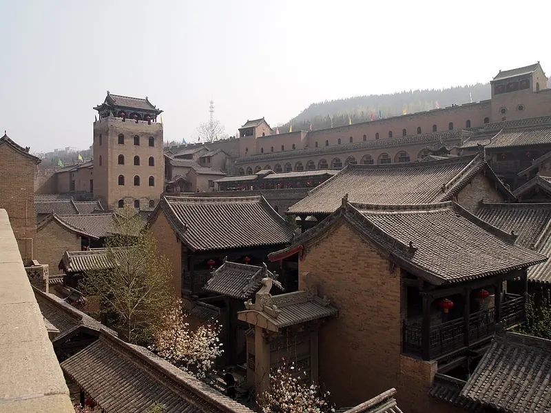
Photo adjustments
Full frame retained; proportionally resized and converted to WebP. No retouching or changes to the photographed subject. Card displays may crop the view.
- Administrative area
- County · 县
- Part of
- Jincheng
- Chinese name
- 阳城县
- Local areas
- County guide
Area & population
- Population · 2020
- 350,474
Source: cited geographic source, as of the dates shown.
Setting and landscape
Mountains cover 55% of the county and heavy hills the rest. The ground falls from south-west to north-east, high in the north and south and lower in the middle, and all of its rivers belong to the Yellow River system. In the south, Mount Xicheng (析城山) reaches 1,888.3 m and has a broad, flat top of about 20 square kilometres called Shengwangping (圣王坪). The southern forests also hold the Manghe (蟒河) national forest park.
History
Yangcheng's old name is Huoze (濩泽), and the county government dates the county to the Western Han, more than 2,000 years ago. Under the Kangxi and Yongzheng emperors of the Qing it was ranked with Hancheng (韩城) in Shaanxi and Tongcheng (桐城) in Anhui as one of three noted cities of learning. During the revolutionary wars it was the seat of the Eighth Route Army's Taiyue (太岳) Military District headquarters. Chinese Wikipedia notes that the former Christian Inn of the Eight Happinesses (八福客栈), outside the county town's east gate, became known in the West through the film The Inn of the Sixth Happiness.
What to see
Chinese Wikipedia counts nine national key cultural relics protection units in the county. One of them is Huangcheng Xiangfu (皇城相府), the mansion built by Chen Tingjing (陈廷敬), a Grand Secretary under the Kangxi Emperor, in Huangcheng village of Beiliu town (北留镇) and listed as his former residence. A national 5A scenic area of 16 courtyards and 640 rooms, its inner town was begun in 1632 and its outer town finished in 1703. Guoyu village (郭峪村) lies across a river from Huangcheng. Walled in 1635, it keeps the seven-storey Yu Tower (豫楼), 33.3 m high.
Haihui Temple (海会寺), in Gouxi village of Runcheng town (润城镇), was founded in the Sui. Emperor Zhaozong of Tang named it Longquan Chan Monastery (龙泉禅院) and Emperor Taizong of Song granted the present name. Its thirteen-storey glazed pagoda was paid for by Li Sixiao (李思孝), a merchant of the town, in the Ming Jiajing and Longqing reigns, and the county government says it was long a place of study and lectures.
Food and local products
Manghe is one of the original homes of the Asiatic cornel (山茱萸), a red medicinal fruit. The county government traces its cultivation in Yangcheng to 1280 and says the local fruit is known as "Yangcheng red" (阳城红). With the Chinese yew, macaques and the giant salamander, the cornel is counted among the four treasures of Manghe (蟒河四宝).
Highlights
- Huangcheng Xiangfu 皇城相府: Mansion of the Kangxi-era Grand Secretary Chen Tingjing in Beiliu town; national 5A scenic area with 16 courtyards.
- Guoyu village 郭峪村: Village walled in 1635, with the seven-storey, 33.3 m Yu Tower; the old buildings are a national protected site.
- Haihui Temple 海会寺: Sui-era temple in Runcheng town named by Tang and Song emperors, with a thirteen-storey glazed Ming pagoda.
- Mount Xicheng 析城山: Southern mountain of 1,888.3 m with a flat top of about 20 square kilometres called Shengwangping.
- Manghe cornel 山茱萸: Medicinal red fruit grown in Yangcheng since at least 1280 by the county's account, known as Yangcheng red.
Sources for this guide
阳城简介 · Yangcheng County People's Government
自然地理 · Yangcheng County People's Government
海会寺 · Yangcheng County People's Government
阳城县 · Wikipedia (Chinese) · CC BY-SA 4.0
皇城相府 · Wikipedia (Chinese) · CC BY-SA 4.0
郭峪村 · Wikipedia (Chinese) · CC BY-SA 4.0
蟒河山茱萸 · Yangcheng County People's Government
Original English written from the listed sources and checked sentence by sentence against quoted extracts by a separate reviewer. Updated 2026-09-25.
Explore Yangcheng County
Core places to explore, with English and Chinese names.
Places to explore around Yangcheng County
Courtyards and towers at the House of the Huangcheng Chancellor. Photograph date recorded by the source: 2014-04-01 10:11:09.House of the Huangcheng Chancellor皇城相府
The House of the Huangcheng Chancellor combines a fortified village with the residence of Chen Tingjing, the Qing official associated with the Kangxi Dictionary. Heshan Tower reveals the defensive needs of the family settlement…
Read the place guide →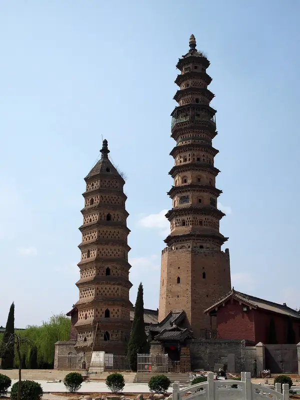 Haihui Academy (海会书院), Yangcheng County. Photograph: "Haihui Temple (Shanxi)".
Haihui Academy海会书院
Haihui Academy (海会书院) in Yangcheng County's Daqiao village combines an old academy, a Buddhist temple and two contrasting historic pagodas.
Read the place guide → Guoyu Ancient City · 郭峪古城
Guoyu Ancient City郭峪古城
Guoyu Ancient City (郭峪古城) is a fortified village in Yangcheng County's Beiliu area, where Ming defensive works surround temple and courtyard architecture.
Read the place guide →Plan your visit
Getting there
Yangcheng County is about 40 km in a straight line from central Jincheng. Search for 阳城县 in a map app to find stations and your accommodation.
Where to stay →Build your route
House of the Huangcheng Chancellor and Haihui Academy are both listed here. The linked place guides have entrance and visit details.
Continue with Jincheng →More in Jincheng
Sources & geographic information
Administrative names and parent areas: Official geographic directory · Reference date 2026-09-06.
Some facts checked against 阳城县 — Wikipedia contributors, CC BY-SA 4.0.
Some facts checked against 皇城相府 — Wikipedia contributors, CC BY-SA 4.0.
Some facts checked against 郭峪村 — Wikipedia contributors, CC BY-SA 4.0.
Photo: House of the Huangcheng Chancellor · Underbar dk · CC BY-SA 4.0. Full frame retained; proportionally resized and converted to WebP. No retouching or changes to the photographed subject. Card displays may crop the view.

Photo: Haihui Academy · Underbar dk · CC BY-SA 4.0. Full frame retained; EXIF orientation normalized, proportionally resized to at most 800 pixels and converted to WebP. No generated pixels or subject changes. Cards may crop the display.

Photo: Guoyu Ancient City · Source photographer · License not provided. EXIF orientation normalized; resized without changing aspect ratio; converted to WebP. No subject edits.
Map data © OpenStreetMap contributors. Pins mark approximate centres, not entrances or boundaries.