

Explore the region
What Mount Siguniang is
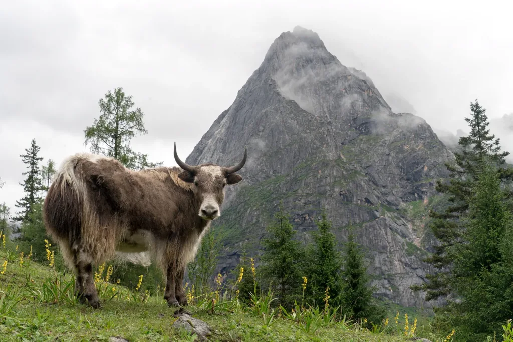
Mount Siguniang is the mountain core of the scenic area known in Chinese as “Three Valleys and One Mountain” (三沟一山). The four named peaks are Dafeng (大姑娘山, 5,025 m), Erfeng (二姑娘山, 5,276 m), Sanfeng (三姑娘山, 5,355 m) and the highest, Yaomei Feng (幺妹峰, 6,247.8 m). You do not need to climb a summit to experience the place: ordinary sightseeing is organised around the three valleys, while climbing is a separate high-altitude activity.
The three valleys are not one continuous visitor trail. The scenic authority presents Shuangqiao, Changping and Haizi as separate visitor sections with their own gates and tickets. Choose the valley that matches your time and fitness, and do not assume that an ordinary ticket gives access to a through-route or to an open summit route.
The wider landscape gained UNESCO Global Geopark status in 2026. UNESCO describes its high mountains and deep valleys, complex folds and granite peaks, while the southern part of the geopark overlaps the Sichuan Giant Panda Sanctuaries—Wolong, Mt Siguniang and Jiajin Mountains World Heritage property. These are landscape and conservation designations, not a reason to leave the managed visitor routes.
Choose a valley
Shuangqiao Valley (双桥沟) is the most developed and easiest valley for a first sightseeing day. A road and sightseeing-bus system reaches the Red-Fir Forest (红杉林) terminal, with stops and boardwalk sections on the return. Look for the contrast between steep granite peaks, alpine meadows, lakes and glacially shaped valleys; named viewpoints include Longzhucuo, Sigunacuo and the Five-Coloured Mountain.
Changping Valley (长坪沟) changes the rhythm. A scenic vehicle takes visitors from the visitor centre to Lama Temple (喇嘛寺), after which the route continues on foot or by horse through forest and meadow scenery towards places such as Muzilu (木骡子). This is the better choice if you want a managed walk rather than a mostly vehicle-based circuit, but the route becomes a real mountain outing as it extends farther in. Camping, crossing toward Bipenggou or climbing are specialist activities, not casual add-ons.
Haizi Valley (海子沟) begins at the town and is the highest of the three valleys. Its early section gives open alpine-meadow views towards the peaks; farther in, high lakes such as Dahaizi and Huahaizi become the focus. Walking or horse riding is the normal way to continue, and the valley is also the approach used by mountaineers. Treat the high-lake and base-camp routes as demanding outdoor travel, not as an extension of a short photo stop.
How to visit
For a simple day, select one valley and start at its own visitor centre. In Shuangqiao, enter at the Shuangqiao visitor centre, ride to the Red-Fir Forest terminal and work back through the managed viewpoints. In Changping, enter at the Changping visitor centre, take the vehicle to Lama Temple and then walk or ride as far as the current route and your conditions allow. In Haizi, enter at the Haizi visitor centre and continue on foot or by horse. The official pages describe all three sections as open year-round, but weather, road conditions and live notices can change the actual entry arrangements.
The official guide currently lists admission at CNY 80 for Shuangqiao, CNY 70 for Changping and CNY 60 for Haizi. It lists a CNY 70 sightseeing vehicle for Shuangqiao and CNY 20 for Changping; horse fees in Haizi are separate. Confirm the date-specific product before payment. A 2026 National Day notice temporarily moved entry earlier to 07:00–15:30 for Shuangqiao and 07:00–15:00 for Changping and Haizi, and stated that extreme weather could change opening times; the notice applied only from 1 to 7 October, so do not treat it as the normal schedule.
The area is high and exposed. The scenic authority advises against strenuous exertion and alcohol, and asks visitors to follow staff instructions, stay on the managed route and respect local Tibetan customs and beliefs. Outdoor hiking, camping, trekking, climbing and other specialist activities must use a legal, open area and follow the reporting, qualified-guide and safety requirements in force. Unopened or undeveloped parts of the nature reserve are prohibited, even when they look close on a map.
Getting there and getting back
Use Siguniangshan Town (四姑娘山镇), Xiaojin County as the road base, not “Mount Siguniang” as if it were one roadside entrance. The scenic authority’s travel guide directs public-transport visitors to a coach from Chadianzi Coach Station (茶店子客运站) in Chengdu to Siguniangshan Town and describes the journey as roughly 200 km and more than three hours. The geopark’s transport page also lists Xinnanmen Coach Station (新南门车站) as an alternative Chengdu departure point. Check the live booking page for your date and arrange the return from Siguniangshan Town before entering a valley; the route pages do not provide a guaranteed current return timetable.
From town, use the Chinese name of the selected visitor centre. The official Shuangqiao page describes self-driving, a scenic shuttle and a town bus for the 8 km approach. The Changping and Haizi pages describe a direct connection from the Shuangqiao entrance to their respective entrances. These are separate access legs, not proof of a walking connection between the valleys.
Combine your visit
Suggested order for the visit:
-
Chosen valley visitor centre
Confirm the open route and return arrangements.
-
Valley boardwalk or managed viewing route
Follow a suitable section of Shuangqiao or Changping.
-
Mountain viewpoint and return
Turn back within the permitted route and available transport.
This is an editorial sequence of named spaces or places. It does not imply a verified walking connection or promise opening, ticket availability or a journey time.
Find Mount Siguniang
四姑娘山 · 小金县
The pin marks the area, not the entrance.
More places nearby
Approximate straight-line distances between map pins, not travel distances.
Wolong National Nature Reserve 卧龙国家级自然保护区
21 km awayWolong is a protected mountain landscape with a central place in giant-panda conservation. It is part of the broader Sichuan Giant Panda Sanctuaries World Heritage property, whose importance extends to forest habitats, plant…
View guide →Bipenggou 毕棚沟
32 km awayBipenggou is a developed mountain valley in Li County, where lakes, forest and high rocky peaks make a varied alpine excursion. Panyang Lake is a natural focus for reflections and a gentler walk, while the route toward Yanziyan…
View guide →Xiling Snow Mountain 西岭雪山
56 km awayXiling Snow Mountain offers several distinct experiences. The Dafeishui front mountain is a walking route, while the ski-field side combines seasonal recreation with a higher sightseeing area at Riyueping. Two cableways serve…
View guide →Sources & visit information
Sources checked on 24 October 2026. Hours, tickets, reservations and transport can change; confirm with the operator before you go.
- 四姑娘山景区 ↗
- 双桥沟 ↗
- 长坪沟 ↗
- 海子沟 ↗
- 官方旅游指南 ↗
- 教科文组织新认定12个世界地质公园 ↗
- Sichuan Giant Panda Sanctuaries - Wolong, Mt Siguniang and Jiajin Mountains ↗
- Boundary Delineation and Explanation of the Relationship with World Heritage Site ↗
- 四姑娘山景区关于国庆假日旅游的通告 ↗
- 关于规范户外运动安全管理的温馨提示 ↗
- 小金县人民政府 四姑娘山自然保护区管理局关于禁止在未开发未开放区域开展一切旅游活动的通告 ↗
- 交通路线 ↗
Image credits & notes (1)
- A yak in Mount Siguniang Scenic Area, with a cloud-covered granite peak behind, Xiaojin County, Sichuan. Photo: George N (Flickr: takoyaki_king)Photo: CC BY 2.0