


Get to know Tianjia'an District
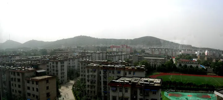
Photo adjustments
Full frame retained; proportionally resized and converted to WebP. No retouching or changes to the photographed subject. Card displays may crop the view.
- Administrative area
- District · 市辖区
- Part of
- Huainan
- Chinese name
- 田家庵区
- Local areas
- District guide
Area & population
- Area in the source
- 255.70 km²
- Population · 2020
- 730,078
- Administrative seat
- Guoqing Subdistrict
Source: cited geographic source, as of the dates shown.
Setting and landscape
Shungeng Mountain crosses the district from east to west for more than 10 kilometres, with 15 hills and a top elevation of 215.72 metres, and divides it into northern and southern parts. North of the ridge the land steps down towards the Huai; south of it, the ground falls towards Wabu Lake. The Huai enters at Shitoubu (石头埠) in Ancheng Town (安成镇) and flows 16.5 kilometres through the district, and the south of the district holds Quanshan Reservoir (泉山水库), Gunzhuang Reservoir (滚庄水库) and Shijian Lake (十涧湖). The district sits in the transition between the subtropical and warm-temperate zones, with a monsoon climate and a marked plum-rain season.
History
Tradition holds that the legendary ruler Shun (虞舜) ploughed on Shungeng Mountain and taught people to farm there. Under the Western Zhou the area belonged to the state of Zhoulai (州来); in 503 BC the state of Cai (蔡) moved its capital into Zhoulai and renamed it Xiacai (下蔡). In 203 BC the Han founder made Ying Bu (英布) King of Huainan, and the area became part of the first Huainan Kingdom (淮南国).
Tianjia'an became a township in 1929 and a town in 1940; Japanese troops occupied it on 2 June 1938. After it was taken on 18 January 1949 it was placed in a special administrative region built around the Huainan coal mines (淮南煤矿), and in September 1950 Huainan city replaced Tianjia'an city. Tianjia'an District dates from 1953. It was renamed Xiangyang District (向阳区) in August 1966, at the start of the Cultural Revolution, and took back its old name in 1972.
What to see
The district government describes the Wuwangdun tomb (武王墩墓) as the largest, highest-ranking and most complex high-status Chu (楚) tomb scientifically excavated so far. Three other sites are provincial protected sites: the Weijiagudui site (魏家孤堆遗址), dating from the Neolithic to the Shang and Zhou; Dagudui (大孤堆), from the Three Kingdoms period; and the Yin clan ancestral hall (尹氏宗祠), from the Daoguang reign of the Qing.
Longhu Park (龙湖公园) is a national 4A scenic area, and the Shungeng Mountain Forest Park (舜耕山森林公园) is a national-level urban scenic area. Central Park (中央公园), Huaihe Park (淮河公园) and Dongshan Park (洞山公园) lie inside the city. The Huainan Museum (淮南市博物馆) is also in the district, together with a study base on the culture of the Huainan coal mines. Paper-cutting and line engraving are among the local intangible-heritage crafts.
Highlights
- Wuwangdun tomb 武王墩墓: Described by the district government as the largest, highest-ranking and most complex high-status Chu tomb scientifically excavated so far.
- Longhu Park 龙湖公园: National 4A scenic area in the district.
- Shungeng Mountain Forest Park 舜耕山森林公园: National-level urban scenic area on the ridge that crosses the district.
- Huainan Museum 淮南市博物馆: The city museum is located in the district.
Sources for this guide
田家庵概况_淮南市田家庵区人民政府 · Tianjia'an District People's Government, Huainan
历史沿革_淮南市田家庵区人民政府 · Tianjia'an District People's Government, Huainan
社会人文_淮南市田家庵区人民政府 · Tianjia'an District People's Government, Huainan
Original English written from the listed sources and checked sentence by sentence against quoted extracts by a separate reviewer. Updated 2026-09-23.
Explore Tianjia'an District
Core places to explore, with English and Chinese names.
Tianjia'an District 田家庵区
Plan your visit
Getting there
Tianjia'an District is about 3 km in a straight line from central Huainan. Search for 田家庵区 in a map app to find stations and your accommodation.
Where to stay →More in Huainan
Sources & geographic information
Administrative names and parent areas: Official geographic directory · Reference date 2026-09-06.
Map data © OpenStreetMap contributors. Pins mark approximate centres, not entrances or boundaries.