


Get to know Dangtu County
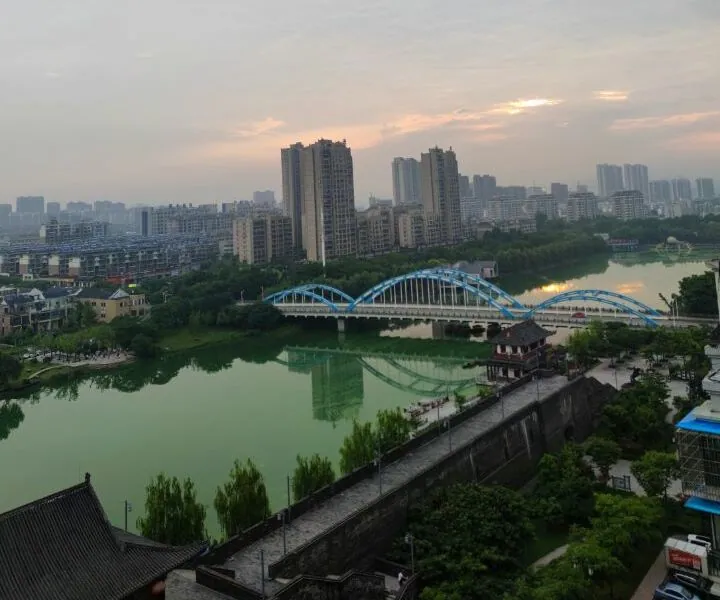
Photo adjustments
Full frame retained; proportionally resized and converted to WebP. No retouching or changes to the photographed subject. Card displays may crop the view.
- Administrative area
- County · 县
- Part of
- Ma'anshan
- Chinese name
- 当涂县
- Local areas
- County guide
Area & population
- Area in the source
- 1,002.00 km²
- Population · 2020
- 446,991
- Administrative seat
- Gushu
Source: cited geographic source, as of the dates shown.
Setting and landscape
Most of the county is plain lying below about 10 to 20 metres above sea level, and its low hills stay under 500 metres. The Yangtze runs down the western side, and rivers such as the Gu Xi (姑溪河) and Qingshan (青山河) flow west or north-west into it. Lakes line the eastern edge; the two largest are Shijiu Lake (石臼湖) and Danyang Lake (丹阳湖). Shijiu Lake, in the south-east, covers 207.65 square kilometres and is linked to the Yangtze.
History
The Qin set up Danyang county here in 221 BC. In 329, when war drove people south from the land between the Yangtze and the Huai, the Eastern Jin created a Dangtu county for them south of the river. In 589 the Sui moved its seat to Gushu, where it has stayed. The town was the seat of Taiping prefecture (太平州) under the Song and of Taiping Prefecture (太平府) under the Ming and Qing. Three old pagodas, Jinzhu (金柱塔), Huangshan (黄山塔) and Lingyun (凌云塔), and the old moat still stand.
The Southern Qi poet Xie Tiao (谢朓) called the area a "capital of hills and waters", and Zhou Xingsi (周兴嗣), a Liang-dynasty writer whose family lived in Gushu, compiled the Thousand Character Classic (千字文). Li Bai came to Dangtu seven times; the county credits him with 56 poems, among them "Gazing at Mount Tianmen" (望天门山), before settling here in old age.
What to see
The Li Bai Cultural Tourism Area (李白文化旅游区), a 4A scenic area 2.5 kilometres south of the county town, is built around Daqingshan (大青山). The hill holds Li Bai's tomb and the site of a shrine to Xie Tiao, who built a retreat there. In the county town, the Taiping Prefecture Cultural Park (太平府文化园) covers 150 mu at the north-western corner of the moat, with a section of old-style city wall, a traditional shopping street, a city god temple and the prefectural yamen.
Food and local traditions
Dangtu's mitten crabs, called "golden feet, red hair" (金脚红毛), were a tribute to the imperial court and are named with the Yangcheng Lake and Baiyangdian crabs as China's "three crabs"; the Shijiu Lake brand is a protected geographical indication product. Huangchi town (黄池镇) is the home of Jincaidi (金菜地) pressed tofu and pickles, a time-honoured brand. Dangtu folk songs (当涂民歌), recorded since the Six Dynasties, entered the first national intangible heritage list in 2006.
Highlights
- Li Bai Cultural Tourism Area 李白文化旅游区: 4A scenic area on Daqingshan with Li Bai's tomb, 2.5 kilometres south of the county town.
- Taiping Prefecture Cultural Park 太平府文化园: City wall, city god temple and prefectural yamen at the corner of the old moat.
- Shijiu Lake 石臼湖: A 207.65-square-kilometre lake linked to the Yangtze, source of the Shijiu Lake crab.
- Dangtu folk songs 当涂民歌: On the first national intangible heritage list, 2006.
- Jincaidi pressed tofu 金菜地茶干: Pressed tofu and pickles from Huangchi town, a time-honoured brand.
Sources for this guide
当涂概况—当涂县人民政府 · Dangtu County People's Government
自然地理—当涂县人民政府 · Dangtu County People's Government
石臼湖_当涂县人民政府 · Dangtu County People's Government
李白文化旅游区_当涂县人民政府 · Dangtu County People's Government
太平府文化园_当涂县人民政府 · Dangtu County People's Government
当涂民歌_当涂县人民政府 · Dangtu County Culture, Tourism and Sports Bureau via Dangtu County People's Government
历史沿革—当涂县人民政府 · Dangtu County People's Government
当涂县 - 维基百科,自由的百科全书 · Wikipedia (Chinese) · CC BY-SA 4.0
Original English written from the listed sources and checked sentence by sentence against quoted extracts by a separate reviewer. Updated 2026-09-23.
Explore Dangtu County
Core places to explore, with English and Chinese names.
Places to explore around Dangtu County
 Li Bai Culture Garden ·
 Plan your visit
Getting there
Dangtu County is about 10 km in a straight line from central Ma'anshan. Search for 当涂县 in a map app to find stations and your accommodation.
Where to stay →Build your route
Start with Li Bai Culture Garden. The linked place guides have entrance and visit details.
Continue with Ma'anshan →More in Ma'anshan
Sources & geographic information
Administrative names and parent areas: Official geographic directory · Reference date 2026-09-06.
Some facts checked against 当涂县 — Wikipedia contributors, CC BY-SA 4.0.
Photo: Li Bai Culture Garden · Source photographer · License not provided. EXIF orientation normalized; resized without changing aspect ratio; converted to WebP. No subject edits.
Map data © OpenStreetMap contributors. Pins mark approximate centres, not entrances or boundaries.