


Get to know He County
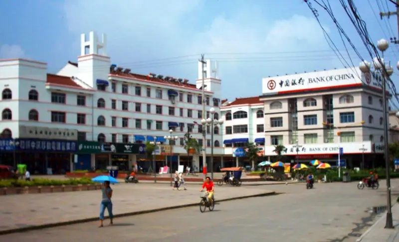
Photo adjustments
Full frame retained; EXIF orientation normalized, proportionally resized to at most 800 pixels and converted to WebP. No generated pixels or subject changes. Cards may crop the display.
- Administrative area
- County · 县
- Part of
- Ma'anshan
- Chinese name
- 和县
- Local areas
- County guide
Area & population
- Population · 2020
- 410,899
- Administrative seat
- Liyang
Source: cited geographic source, as of the dates shown.
Setting and landscape
The southern, riverside part of the county is Yangtze alluvial plain, laced with creeks and dotted with reservoirs and ponds. The north-west is undulating hill country, highest at Rufang Mountain (如方山, 315 m). The Chu River (滁河) forms the northern boundary, the county has 41.6 km of Yangtze shoreline, and a bridge links it with Pukou District (浦口区) of Nanjing.
History
Liyang County (历阳县) was set up here in 221 BC. After the Southern Liang and Northern Qi made peace here in 555, the place was renamed Hezhou (和州); it became He County after the 1911 Revolution, and Anhui listed it as a provincial historic and cultural city in 1996. Xiang Yu (项羽), the Hegemon-King of Western Chu, took his own life at Wujiang (乌江), now a town in the county.
In 1980 and 1981 a nearly complete skullcap, skull fragments, a broken lower jaw and nine teeth were found in Longtan Cave (龙潭洞) on Wangjia Hill (汪家山) at Taodian (陶店); they are known as Hexian Man (和县猿人).
What to see
Jilong Mountain (鸡笼山), 25 km north-west of the county town, is named after a summit rock said to look like a chicken coop. It holds the Fenglin Chan Temple (凤林禅寺) and a Hall of the Three Pure Ones (三清殿); beyond the temple halls, near-vertical bluestone steps with rails and chains lead up through a one-person cleft, Yixiantian (一线天). With Banyue Lake (半月湖) it forms a national 4A scenic area.
In the centre of the old town, Loushi Park (陋室公园) keeps the Humble Room (陋室), the residence Liu Yuxi (刘禹锡) used while serving in Hezhou and the subject of his Inscription on the Humble Room (陋室铭). Rebuilt as nine rooms under the Qianlong Emperor and listed as an Anhui protected site in 1986, it is now the Liu Yuxi Memorial Hall. With Zhenhuai Old Street (镇淮古街), home to a Confucian temple and Zhenhuai Tower (镇淮楼), it became a national 3A area in 2016.
Food and local products
Bawang pastry (霸王酥) is a small square crisp pastry from Wujiang; legend says the defeated Xiang Yu ate more than thirty pieces, and the name was fixed in the 1980s. The county is styled China's home of vegetables and is a main supplier of vegetables to Nanjing and Hefei (合肥). He County golden melon (和县黄金瓜) is a Chinese geographical indication product.
Highlights
- Jilong Mountain and Banyue Lake 鸡笼山—半月湖: National 4A scenic area 25 km north-west of the county town, with the Fenglin Chan Temple and a steep stone-step climb.
- Humble Room 陋室: Residence Liu Yuxi used while serving in Hezhou, now the Liu Yuxi Memorial Hall; an Anhui protected site since 1986.
- Hexian Man site 和县猿人: Skull, jaw and teeth found in 1980 and 1981 in Longtan Cave at Taodian.
- Bawang pastry 霸王酥: Small square flaky pastry from Wujiang, tied by legend to Xiang Yu.
Sources for this guide
和县概况_和县人民政府 · He County People's Government
区位_和县人民政府 · He County People's Government
和县鸡笼山,凭什么是“江北第一名山”?_和县人民政府 · He County People's Government
和县这一室舍,何以流芳千古?_和县人民政府 · He County People's Government
霸王酥_和县人民政府 · He County People's Government
和县 - 维基百科,自由的百科全书 · Wikipedia (Chinese) · CC BY-SA 4.0
Original English written from the listed sources and checked sentence by sentence against quoted extracts by a separate reviewer. Updated 2026-09-23.
Explore He County
Core places to explore, with English and Chinese names.
Plan your visit
Getting there
He County is about 15 km in a straight line from central Ma'anshan. Search for 和县 in a map app to find stations and your accommodation.
Where to stay →More in Ma'anshan
Sources & geographic information
Administrative names and parent areas: Official geographic directory · Reference date 2026-09-06.
Some facts checked against 和县 — Wikipedia contributors, CC BY-SA 4.0.
Map data © OpenStreetMap contributors. Pins mark approximate centres, not entrances or boundaries.