


Get to know Yushan District

- Administrative area
- District · 市辖区
- Part of
- Ma'anshan
- Chinese name
- 雨山区
- Local areas
- District guide
Area & population
- Area in the source
- 173.00 km²
- Population · 2020
- 355,986
- Administrative seat
- Yushan Subdistrict
Source: cited geographic source, as of the dates shown.
Setting and landscape
The ground rises from west to east. The eastern hills, 100 to 200 m high, are where Ma'anshan's Cihu River (慈湖河) and Caishi River (采石河) rise, and Kaoshan (烤山) is the top point at 232 m. The centre and west are polder plain criss-crossed by ditches and dotted with lakes and ponds, and along the Yangtze a narrow line of hills, including Cuiluo Hill (翠螺山) and Xishan (西山), runs south to north. Iron ore lies under Nanshan (南山), Xiangshan (向山), Mashan (马山) and Huangmeishan (黄梅山); the Aoshan (凹山) open-pit mine was known as the granary of Masteel (马钢).
History
Caishi appears in Qin records more than 2,200 years ago under the name Niuzhu (牛渚). From 1080 the area belonged to Dangtu County (当涂县), and it stayed there until Ma'anshan became a city in 1956. Yushan District itself was created on 1 June 1976; it absorbed Xiangshan town and neighbouring townships in 2001 and Yintang town (银塘镇) from Dangtu in 2004.
What to see
Caishiji, also called Niuzhuji (牛渚矶), sits at the foot of Cuiluo Hill in the south-west of the city. It is grouped with Chenglingji (城陵矶) and Yanziji (燕子矶) as the Three Rocks of the Yangtze (长江三矶), and inside the area are the Taibai Tower (太白楼), the Li Bai Memorial Hall (李白纪念馆), the Lin Sanzhi Art Museum (林散之艺术馆) and Sanyuan Cave (三元洞). It was named a national 5A scenic area on 29 December 2020.
The district government also lists the tomb of Zhu Ran (朱然墓), counted as one of China's ten major archaeological discoveries of the 1980s; Guangji Temple (广济寺); Xiaojiuhua Temple (小九华寺); the early human site at Yandunshan (烟墩山); and Yushan Lake (雨山湖). At Xiangshan town the Aoshan Geological Culture Park (凹山地质文化公园), opened on 19 February 2022 in a former Masteel open-pit iron mine, has a viewing platform and a display of mining equipment.
Food and local products
Caishiji dried tofu (采石矶茶干) is a dark red pressed bean curd made from local soybeans with licorice, soaked, ground, curdled, scored and braised, and eaten with tea. It was a Qing tribute item by the Jiaqing era, became a China Time-honoured Brand in 2011, and its making was put on the Anhui intangible heritage list in 2017. The Caishi Tiao Hehe dance (采石跳和合) joined the same list in 2008.
Highlights
- Caishiji 采石矶: National 5A scenic area at the foot of Cuiluo Hill, with the Taibai Tower and Li Bai Memorial Hall.
- Zhu Ran tomb 朱然墓: Tomb counted among China's ten major archaeological discoveries of the 1980s.
- Aoshan Geological Culture Park 凹山地质文化公园: Former Masteel open-pit iron mine at Xiangshan town, opened as a park in 2022.
- Caishiji dried tofu 采石矶茶干: Braised pressed bean curd; its making is on the Anhui intangible heritage list (2017).
Sources for this guide
雨山概况_马鞍山市雨山区人民政府 · Yushan District People's Government, Ma'anshan
采石矶_马鞍山市人民政府 · Ma'anshan Municipal People's Government
凹山地质文化公园_马鞍山市人民政府 · Ma'anshan Municipal People's Government
人间美味——采石矶茶干_马鞍山市雨山区人民政府 · Yushan District People's Government, Ma'anshan
拾遗雨山,采石跳和合_马鞍山市雨山区人民政府 · Yushan District People's Government, Ma'anshan
雨山区 - 维基百科,自由的百科全书 · Wikipedia (Chinese) · CC BY-SA 4.0
Original English written from the listed sources and checked sentence by sentence against quoted extracts by a separate reviewer. Updated 2026-09-23.
Explore Yushan District
Core places to explore, with English and Chinese names.
Places to explore around Yushan District
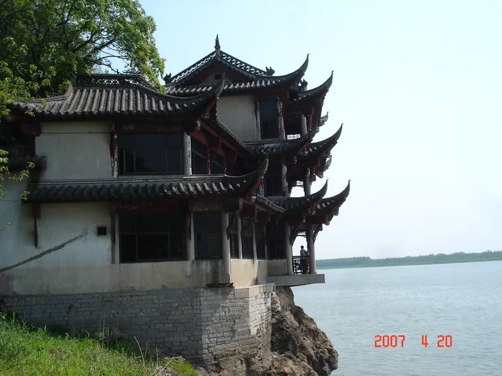 The Sanyuan Cave pavilion on the cliffs of Caishiji above the Yangtze River, Ma'anshan ·
 Plan your visit
Getting there
Yushan District covers the centre of Ma'anshan. Search for 雨山区 in a map app to find stations and your accommodation.
Where to stay →Build your route
Start with Caishiji. The linked place guides have entrance and visit details.
Continue with Ma'anshan →More in Ma'anshan
Sources & geographic information
Administrative names and parent areas: Official geographic directory · Reference date 2026-09-06.
Some facts checked against 雨山区 — Wikipedia contributors, CC BY-SA 4.0.
Photo: Caishiji · 陈宏宇 · CC BY 3.0. Full frame retained; proportionally resized and converted to WebP. No retouching or changes to the photographed subject. Card displays may crop the view.
.jpg)
Map data © OpenStreetMap contributors. Pins mark approximate centres, not entrances or boundaries.