


Get to know Sai Kung District
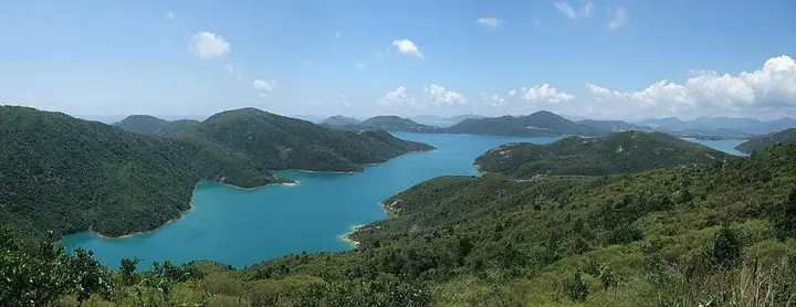
Photo adjustments
The author’s Commons source is a continuous panorama stitched from four real photographs of the same High Island Reservoir scene. Exact downloaded source bytes are separately retained and hashed. Local preparation only proportionally reduced the complete source panorama to a maximum 720-pixel long edge and encoded it as JPEG; no additional stitching, cropping or subject alteration was performed locally. Final website rendition: full frame retained, proportionally resized to at most 720 pixels and converted to WebP. No additional retouching or subject alteration. Card displays may crop the view.
- Administrative area
- District · 地區
- Part of
- Hong Kong
- Chinese name
- 西貢
- Local areas
- District guide
Setting and landscape
Apart from its villages, the Sai Kung Peninsula is almost all taken up by Sai Kung East and Sai Kung West country parks, about 7,500 hectares together. Hikers and campers head for the Cheung Sheung plateau. The peninsula and nearby islands are almost wholly volcanic; sea caves, stacks and arches cut into the acid lavas of Jin Island (吊鐘洲). Sharp Island (橋咀洲), High Island, the Ninepin Group and the Ung Kong Group make up the Sai Kung Volcanic Rock Region of the Hong Kong UNESCO Global Geopark, where hexagonal volcanic rock columns formed some 16.5 to 14 million years ago crop out.
What to see
High Island Reservoir (萬宜水庫), listed by the district council as Hong Kong's largest, was made by damming both ends of the channel between High Island and the peninsula; its eastern dam has a cofferdam of dolosse units. At Pak Tam Chung, the Sheung Yiu Folk Museum (上窰民俗文物館) occupies a Hakka village founded by a Wong clan in the late 19th century; the village and its lime kiln became monuments in 1981 and the museum opened in 1984.
Che Kung Temple at Ho Chung (蠔涌車公廟), on the Ho Chung River, is among Hong Kong's oldest temples and has served the village for more than 300 years, and the Tin Hau Temple at Joss House Bay (大廟) faces the bay in the inner waters of the Fat Tong Mun Channel. On Yim Tin Tsai (鹽田仔), Catholic missionaries built a chapel about 150 years ago. At Tsam Chuk Wan, a monument to Sai Kung's wartime martyrs, funded by veterans of the Dongjiang Column's Hong Kong Independent Battalion and residents, was unveiled in 1989 and added to the State Council's list of war-of-resistance sites in 2020.
Food and local products
Sai Kung Town has a dense cluster of seafood restaurants, and Leung Shuen Wan (糧船灣), a designated fish culture zone, has seafood restaurants along its shore and a Tin Hau temple built by fishermen.
Getting oriented
The MTR serves Tseung Kwan O New Town, built on reclaimed land in the former Junk Bay; the main roads within the district are Hiram's Highway, Clear Water Bay Road and Sai Sha Road. The district's outside road links are the Tseung Kwan O Tunnel, Po Lam Road and the Tseung Kwan O - Lam Tin Tunnel, opened in 2022.
Highlights
- High Island Reservoir 萬宜水庫: Listed by the Sai Kung District Council as Hong Kong's largest reservoir, formed by damming a sea channel.
- Sheung Yiu Folk Museum 上窰民俗文物館: Late-19th-century Hakka village and lime kiln, monuments since 1981, museum since 1984.
- Sharp Island 橋咀洲: Part of the Sai Kung Volcanic Rock Region of the Hong Kong UNESCO Global Geopark.
- Che Kung Temple, Ho Chung 蠔涌車公廟: On the Ho Chung River; has served Ho Chung Village for more than 300 years.
- Yim Tin Tsai chapel 鹽田仔: Chapel built by Catholic missionaries about 150 years ago.
Sources for this guide
Home Affairs Department - Sai Kung District · Home Affairs Department, Hong Kong SAR Government
Sai Kung District Council - District Highlights · Sai Kung District Council, Hong Kong SAR Government
Sai Kung District · Wikipedia · CC BY-SA 4.0
Original English written from the listed sources and checked sentence by sentence against quoted extracts by a separate reviewer. Updated 2026-09-25.
Explore Sai Kung District
Core places to explore, with English and Chinese names.
Places to explore around Sai Kung District
Panoramic view of High Island Reservoir and surrounding hills · 万宜水库与群山全景 Photograph date recorded by the source: 17 August 2008.High Island Reservoir万宜水库
High Island Reservoir’s East Dam brings water-engineering structures and volcanic geology together. Quarrying for the reservoir exposed pale hexagonal rock columns, including an S-shaped section cut by a dark dyke. The geotrail…
Read the place guide →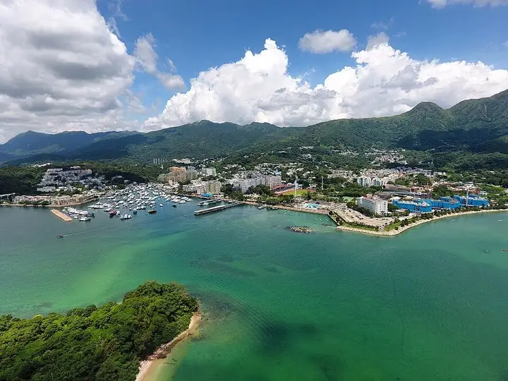 Sai Kung Town and harbour · 西贡市与海港 Photograph date recorded by the source: 28 June 2017.
Sai Kung西貢
Sai Kung Town is a useful destination before any excursion to its surrounding islands. The waterfront combines small-boat activity with seafood restaurants and display tanks, while the older streets behind contain everyday shops…
Read the place guide → Sharp Island and its surrounding waters · 桥咀洲与周边海域 Photograph date recorded by the source: 21 August 2017.
Sharp Island桥咀洲
Sharp Island’s western shore offers a compact introduction to volcanic rocks and tidal landforms. The rounded boulders called Pineapple Bun Rocks have cracked surfaces formed through weathering, while a sand-and-gravel tombolo…
Read the place guide →Plan your visit
Getting there
Sai Kung District is about 10 km in a straight line from central Hong Kong. Search for 西貢 in a map app to find stations and your accommodation.
Where to stay →Build your route
High Island Reservoir and Sai Kung are about 8 km apart in a straight line. The linked place guides have entrance and visit details.
Continue with Hong Kong →More in Hong Kong
Sources & geographic information
Administrative names and parent areas: Official geographic directory · Reference date 2026-09-06.
Some facts checked against Sai Kung District — Wikipedia contributors, CC BY-SA 4.0.
Photo: High Island Reservoir · Minghong · Minghong — High_Island_Reservoir_3.jpg — CC BY-SA 4.0 · CC BY-SA 4.0. The author’s Commons source is a continuous panorama stitched from four real photographs of the same High Island Reservoir scene. Exact downloaded source bytes are separately retained and hashed. Local preparation only proportionally reduced the complete source panorama to a maximum 720-pixel long edge and encoded it as JPEG; no additional stitching, cropping or subject alteration was performed locally. Final website rendition: full frame retained, proportionally resized to at most 720 pixels and converted to WebP. No additional retouching or subject alteration. Card displays may crop the view.

Photo: Sai Kung · Wpcpey · Wpcpey — Sai_Kung_Town_Aerial_View_201706.jpg — CC BY-SA 4.0 · CC BY-SA 4.0. The exact downloaded source bytes are separately retained and hashed. Prepared JPEG is proportionally reduced to a maximum 720-pixel long edge; full frame retained, no subject alteration. Final website rendition: full frame retained, proportionally resized to at most 720 pixels and converted to WebP. No additional retouching or subject alteration. Card displays may crop the view.

Photo: Sharp Island · Geographer · Geographer at English Wikipedia · CC BY-SA 4.0. The exact downloaded source bytes are separately retained and hashed. Prepared JPEG is proportionally reduced to a maximum 720-pixel long edge; full frame retained, no subject alteration. Final website rendition: full frame retained, proportionally resized to at most 720 pixels and converted to WebP. No additional retouching or subject alteration. Card displays may crop the view.

Map data © OpenStreetMap contributors. Pins mark approximate centres, not entrances or boundaries.