


Get to know Southern District
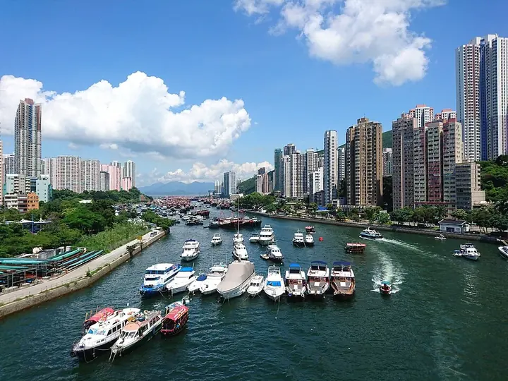
Photo adjustments
Full frame retained; proportionally resized and converted to WebP. No retouching or changes to the photographed subject. Card displays may crop the view.
- Administrative area
- District · 地區
- Part of
- Hong Kong
- Chinese name
- 南區
- Local areas
- District guide
Area & population
- Area in the source
- 38.80 km²
Source: cited geographic source, as of the dates shown.
Setting and landscape
Hills and reservoirs protected as country parks form the district's northern edge. The Home Affairs Department lists its main localities from east to west as Big Wave Bay, Shek O (石澳), Tai Tam (大潭), Stanley (赤柱), Chung Hom Kok (舂坎角), Repulse Bay (淺水灣), Wong Chuk Hang (黃竹坑), Aberdeen (香港仔), Ap Lei Chau (鴨脷洲) and Pok Fu Lam. The eastern half is semi-rural and holds most of the beaches; the western half mixes housing estates with industry. Ap Lei Chau is an island joined to Aberdeen by three bridges, two for roads and one for the railway, and Cape D'Aguilar (鶴咀) has a marine reserve.
What to see
Several of Hong Kong's best-known beaches are here, among them Shek O, Deep Water Bay (深水灣) and Repulse Bay. Aberdeen keeps the look of a fishing port: the Southern District Council points to the Aberdeen Fish Market and the typhoon shelters. Ocean Park (海洋公園), a theme park, sits in the district; the souvenir market at Stanley and the Home of Teresa Teng are among the other attractions listed for the district. On the western shore, Cyberport (數碼港) at Telegraph Bay is a technology park of about 24 hectares with offices, a conference centre, a hotel and a shopping centre.
Festivals
The district council names the Hung Shing Festival (洪聖誕), dragon boat races and fire dragon dances as annual celebrations, and the Home Affairs Department adds the Tai Ping Ching Chiu (太平清醮), a feast for the dead held once every ten years.
Getting oriented
The Aberdeen Tunnel is the main road link between Wong Chuk Hang and Causeway Bay on the north shore. Rail came late: the MTR reached the district only in 2016, when the South Island line began running from Admiralty to Wong Chuk Hang and Ap Lei Chau, making Southern the final Hong Kong district to get a metro service.
Highlights
- Aberdeen Typhoon Shelter 香港仔避风塘: The Home Affairs Department describes it as having the ambience of a traditional fishing port.
- Repulse Bay 浅水湾: One of the district's beaches; the Home Affairs Department calls it Western-flavoured.
- Shek O 石澳: An eastern locality whose beach the Home Affairs Department names among Hong Kong's famous beaches.
- Ocean Park 香港海洋公园: Theme park in the district, named by both the Home Affairs Department and the district council.
- Stanley 赤柱: Seaside area with a souvenir market.
Sources for this guide
Home Affairs Department - Southern District · Home Affairs Department, Hong Kong SAR Government
Southern District, Hong Kong · Wikipedia · CC BY-SA 4.0
Southern District Council - District Highlights · Southern District Council, Hong Kong SAR Government
Original English written from the listed sources and checked sentence by sentence against quoted extracts by a separate reviewer. Updated 2026-09-25.
Explore Southern District
Core places to explore, with English and Chinese names.
Places to explore around Southern District
 Waterfront walkway at Aberdeen Promenade · 香港仔海滨公园沿海步道 Photograph date recorded by the source: 18 August 2015.
Aberdeen Promenade香港仔海滨公园
Aberdeen Promenade faces the sheltered water between Aberdeen and Ap Lei Chau. Fishing vessels and smaller harbour craft give the view a working-waterfront character, while the public landscaping uses the theme of a traditional…
Read the place guide → Dragons Back trailhead on Shek O Road · 石澳道龙脊径起点 Photograph date recorded by the source: Taken on 23 January 2015.
Dragon's Back龙脊
Dragon’s Back follows the ridge between Shek O Peak and Wan Cham Shan. Its changing crests reveal sea views on both sides, with green slopes falling towards the coast. The official longer route continues through the Pottinger…
Read the place guide → Ocean Park · 香港海洋公园
Ocean Park香港海洋公园
Ocean Park is divided by a mountain into the Waterfront and the Summit. A cable car and the Ocean Express funicular connect the two sides, so the journey through the terrain forms part of the experience. Animal habitats, an…
Read the place guide → Repulse Bay beach and waterfront viewed from the hillside · 浅水湾泳滩与海湾全景 Photograph date recorded by the source: 11 April 2021.
Repulse Bay浅水湾
Repulse Bay combines a curved sandy beach with a built-up residential backdrop on Hong Kong Island’s southern coast. At the southeastern end, large figures of Tin Hau and Kwun Yam stand among colourful shrine decorations, adding…
Read the place guide → Shek O village and peninsula viewed from Dragon’s Back · 石澳 Photograph date recorded by the source: 1 November 2014, 14:52:12.
Shek O石澳
Shek O combines a sandy public beach with a village on the south-eastern coast of Hong Kong Island. The village streets, entrance arch and Tin Hau Temple provide a built setting behind the beach, while the rocky headland…
Read the place guide →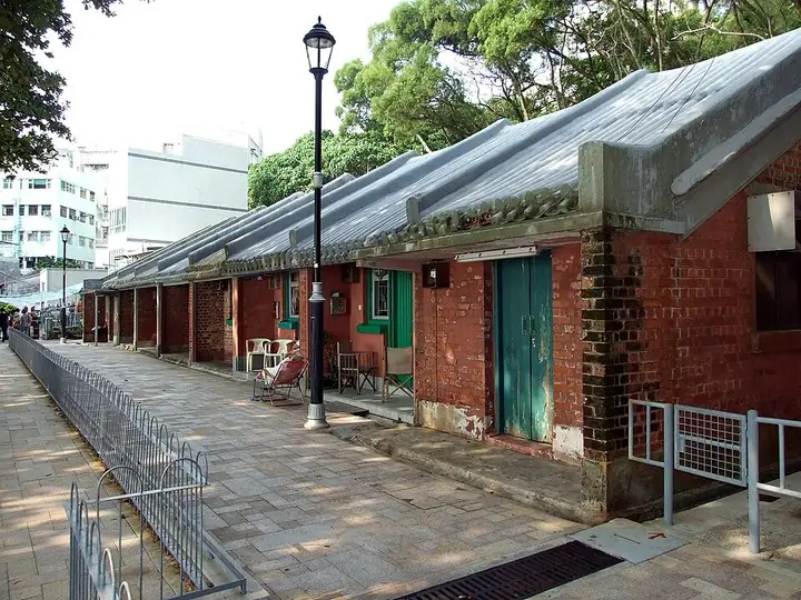 Pat Kan row houses in Stanley · 赤柱八间屋 Photograph date recorded by the source: 3 October 2009.
Stanley赤柱
Stanley offers three different settings close to the southern waterfront: the small lanes of its market, the open frontage of Main Street, and the colonnaded Murray House. Browse the market for crafts and clothing, then leave…
Read the place guide → Fishing boats and sampans moored in the Aberdeen Typhoon Shelter, with the high-rises of Aberdeen behind · 香港仔避风塘内停泊的渔船与舢板,背后是香港仔的高楼 Source-recorded photograph date: 2016-11-13 10:59:53.
Aberdeen Typhoon Shelter香港仔避风塘
Aberdeen Typhoon Shelter is a working harbour landscape on the southern side of Hong Kong Island, facing Ap Lei Chau.
Read the place guide → Dragon’s Back Hike · 龙脊徒步
Dragon’s Back Hike龙脊徒步
Dragon’s Back is an undulating ridge between Wan Cham Shan and Shek O Peak in southeastern Hong Kong Island.
Read the place guide →Plan your visit
Getting there
Southern District is about 8 km in a straight line from central Hong Kong. Search for 南區 in a map app to find stations and your accommodation.
Where to stay →Build your route
Aberdeen Promenade and Dragon's Back are about 9 km apart in a straight line. The linked place guides have entrance and visit details.
Continue with Hong Kong →More in Hong Kong
Sources & geographic information
Administrative names and parent areas: Official geographic directory · Reference date 2026-09-06.
Some facts checked against Southern District, Hong Kong — Wikipedia contributors, CC BY-SA 4.0.
Photo: Aberdeen Promenade · Wing1990hk · Wing1990hk — Aberdeen_Promenade_201508.jpg — CC BY 3.0 · CC BY 3.0. The exact downloaded source bytes are separately retained and hashed. Prepared JPEG is proportionally reduced to a maximum 720-pixel long edge; full frame retained, no subject alteration. Final website rendition: full frame retained, proportionally resized to at most 720 pixels and converted to WebP. No additional retouching or subject alteration. Card displays may crop the view.

Photo: Dragon's Back · rheins · CC BY 3.0. The exact downloaded source bytes are separately retained and hashed. Prepared JPEG is proportionally reduced to a maximum 720-pixel long edge; full frame retained, no subject alteration. Final website rendition: full frame retained, proportionally resized to at most 720 pixels and converted to WebP. No additional retouching or subject alteration. Card displays may crop the view.

Photo: Ocean Park · Exploringlife · CC BY-SA 4.0. Wikimedia thumbnail; fitted to the ranking-card frame.

Photo: Repulse Bay · Shanghai88 · Shanghai88 — View_of_Repulse_Bay_from_Sir_Cecil's_Ride.jpg — CC BY-SA 4.0 · CC BY-SA 4.0. The exact downloaded source bytes are separately retained and hashed. Prepared JPEG is proportionally reduced to a maximum 720-pixel long edge; full frame retained, no subject alteration. Final website rendition: full frame retained, proportionally resized to at most 720 pixels and converted to WebP. No additional retouching or subject alteration. Card displays may crop the view.

Photo: Shek O · 山民主義 · CC BY-SA 4.0. Full frame retained; proportionally resized and converted to WebP. No retouching or changes to the photographed subject. Card displays may crop the view.

Photo: Stanley · Chong Fat · Chong Fat — HK_PatKanStanley.JPG — CC BY-SA 3.0 · CC BY-SA 3.0. The exact downloaded source bytes are separately retained and hashed. Prepared JPEG is proportionally reduced to a maximum 720-pixel long edge; full frame retained, no subject alteration. Final website rendition: full frame retained, proportionally resized to at most 720 pixels and converted to WebP. No additional retouching or subject alteration. Card displays may crop the view.

Photo: Aberdeen Typhoon Shelter · Ceeseven · CC BY-SA 4.0. Full frame retained; proportionally resized and converted to WebP. No retouching or changes to the photographed subject. Card displays may crop the view.

Photo: Dragon’s Back Hike · Source photographer · License not provided. EXIF orientation normalized; resized without changing aspect ratio; converted to WebP. No subject edits.
Map data © OpenStreetMap contributors. Pins mark approximate centres, not entrances or boundaries.