


Get to know Chongming District

Photo adjustments
Full frame retained; resized proportionally to a maximum dimension of 960 pixels and converted to WebP quality 88. No crop, retouch, generated elements, or subject alteration. Final website rendition: full frame retained, proportionally resized to at most 720 pixels and converted to WebP. No additional retouching or subject alteration. Card displays may crop the view.
- Administrative area
- District · 市辖区
- Part of
- Shanghai
- Chinese name
- 崇明区
- Local areas
- District guide
Area & population
- Area in the source
- 1,411.00 km²
- Population · 2020 Census
- 637,921
Source: cited geographic source, as of the dates shown.
Setting and landscape
The district government describes Chongming Island as the world's largest estuarine alluvial island and China's third-largest island after Taiwan and Hainan. It is about 80 kilometres long from east to west and 13 to 18 kilometres wide, completely flat, with no hills. Changxing is a long, narrow island in the Yangtze's southern channel off Wusong (吴淞口), and Hengsha, shaped like a conch shell, is the easternmost island of the estuary.
History
The island grew out of shifting sandbanks. Two banks, the West and East Sands, rose in the estuary during the Tang Wude period (618–626), and fishermen and woodcutters settled on the West Sand from 696. In 937 the town of Chongming (崇明镇) was set up on the West Sand, the first administrative unit on the sandbanks. Salt making began in the early Northern Song, when convicts were sent to boil salt here.
Because banks kept washing away and building up, the seat of government was rebuilt six times and moved five times before settling. In 1659 Koxinga (郑成功) attacked the county seat, today's Chengqiao (城桥镇), and was driven off. Chongming passed from Jiangsu to Shanghai in 1958, took in Changxing and Hengsha from Baoshan in 2005, and became a district in 2016. Changxing Island formed during the Daoguang reign (1821–1850) and Hengsha during the Xianfeng reign (1851–1861).
What to see
At the eastern tip of Chongming Island, the Chongming Dongtan Birds National Nature Reserve (崇明东滩鸟类国家级自然保护区) protects wetland used by migratory birds. It joined the World Heritage List in 2024 as part of the migratory bird habitats of the Yellow Sea and Bohai coast of China (中国黄(渤)海候鸟栖息地).
Dongping National Forest Park (东平国家森林公园), in the north-centre of the island, was converted from the Dongping forestry farm set up in 1959; its central lake, Shuishan Lake (水杉湖), is named after the dawn redwoods that surround it. Mingzhu Lake Park (明珠湖公园) holds Mingzhu Lake, the largest freshwater lake on Chongming Island, with a water-conservation forest around it and a display of fish specimens from the lake and the Yangtze estuary; it is a national 5A scenic area.
Highlights
- Chongming Dongtan Birds National Nature Reserve 崇明东滩鸟类国家级自然保护区: Migratory bird wetland at the island's eastern tip; World Heritage since 2024.
- Dongping National Forest Park 东平国家森林公园: Planted forest on a former 1959 forestry farm, centred on Shuishan Lake.
- Mingzhu Lake Park 明珠湖公园: Largest freshwater lake on Chongming Island; national 5A scenic area.
Sources for this guide
崇明概况 · Chongming District People's Government, Shanghai
上海崇明东滩鸟类国家级自然保护区 - 维基百科 · Wikipedia (Chinese) · CC BY-SA 4.0
东平国家森林公园 - 维基百科 · Wikipedia (Chinese) · CC BY-SA 4.0
明珠湖公园 - 维基百科 · Wikipedia (Chinese) · CC BY-SA 4.0
Original English written from the listed sources and checked sentence by sentence against quoted extracts by a separate reviewer. Updated 2026-09-25.
Explore Chongming District
Core places to explore, with English and Chinese names.
Places to explore around Chongming District
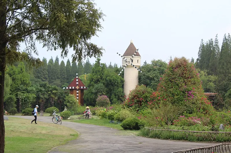 Landscaped grounds in Dongping National Forest Park, Chongming. Photograph date recorded by the source: 2018-09-01 13:01:34.
Dongping National Forest Park东平国家森林公园
Dongping National Forest Park grew from a planted forest on Chongming Island. Its landscape combines substantial tree cover with themed planting areas and a lake bordered by metasequoias.
Read the place guide → Xisha Mingzhu Lake Scenic Area · 西沙明珠湖景区
Xisha Mingzhu Lake Scenic Area西沙明珠湖景区
Xisha Mingzhu Lake combines a wetland park and a freshwater lake landscape on Chongming Island.
Read the place guide → Chongming Dongtan Visitor Birdwatching Areas · 崇明东滩开放观鸟区
Chongming Dongtan Visitor Birdwatching Areas崇明东滩开放观鸟区
Chongming Dongtan is an estuary wetland landscape at the eastern end of Chongming Island.
Read the place guide → A timber boardwalk with brown railings running out from the camera over a tidal wetland: mudflats and shallow channels, reed beds and bare scrubby trees, a white-railed walkway crossing the middle distance, and the flat estuary horizon beyond.
Xisha Wetland and Mingzhu Lake西沙湿地与明珠湖
Xisha Wetland and Mingzhu Lake form a combined scenic area in the western part of Shanghai's Chongming Island.
Read the place guide →Plan your visit
Getting there
Chongming District is about 50 km in a straight line from central Shanghai. Search for 崇明区 in a map app to find stations and your accommodation.
Where to stay →Build your route
Dongping National Forest Park and Xisha Mingzhu Lake Scenic Area are both listed here. The linked place guides have entrance and visit details.
Continue with Shanghai →More in Shanghai
Sources & geographic information
Administrative names and parent areas: Official geographic directory · Reference date 2026-09-06.
Some facts checked against 上海崇明东滩鸟类国家级自然保护区 — Wikipedia contributors, CC BY-SA 4.0.
Some facts checked against 东平国家森林公园 — Wikipedia contributors, CC BY-SA 4.0.
Some facts checked against 明珠湖公园 — Wikipedia contributors, CC BY-SA 4.0.
Photo: Dongping National Forest Park · Milkomède · CC BY-SA 4.0. Full frame retained; proportionally resized and converted to WebP. No retouching or changes to the photographed subject. Card displays may crop the view.

Photo: Xisha Mingzhu Lake Scenic Area · Source photographer · License not provided. EXIF orientation normalized; resized without changing aspect ratio; converted to WebP. No subject edits.
Photo: Chongming Dongtan Visitor Birdwatching Areas · Source photographer · License not provided. EXIF orientation normalized; resized without changing aspect ratio; converted to WebP. No subject edits.
Photo: Xisha Wetland and Mingzhu Lake · jaysonh · CC BY 3.0. Full frame retained; proportionally resized and converted to WebP. No retouching or changes to the photographed subject. Card displays may crop the view.

Map data © OpenStreetMap contributors. Pins mark approximate centres, not entrances or boundaries.