


Get to know Fuding

Photo adjustments
Full frame retained; proportionally resized and converted to WebP. No retouching or changes to the photographed subject. Card displays may crop the view.
- Administrative area
- County-level city · 县级市
- Part of
- Ningde
- Chinese name
- 福鼎市
- Local areas
- County-level city guide
Area & population
- Area in the source
- 1,484.00 km²
- Population · 2020 census
- 553,132
Source: cited geographic source, as of the dates shown.
Setting and landscape
The city faces the East China Sea to the southeast. Cangnan County (苍南县) in Zhejiang lies to the northeast and Taishun County (泰顺县), also in Zhejiang, to the northwest, with Zherong County (柘荣县) to the west and Xiapu County (霞浦县) to the south. Its land area is 1,461 square kilometres, and its sea area is roughly ten times that. Chinese Wikipedia counts 88.1 percent of the land as mountain and hill, with the ground falling toward the southeast coast, a coastline of 432.7 kilometres, and 81 islands, among them the Fuyao (福瑶列岛), Xingzai (星仔列岛) and Taishan (台山列岛) groups. The city seat, Tongshan (桐山), lies between two streams, the Tongshan (桐山溪) and the Longshan (龙山溪).
History
Fuding became a county in 1739, when four rural districts were taken from Xiapu. Local gazetteers say the name comes from Fuding Mountain (福鼎山), a peak east of the county town that stays in view from tens of li (里) away. When the People's Liberation Army took the county in June 1949 it was briefly placed under Wenzhou (温州) in Zhejiang, before returning to Fujian in October that year, and on 13 October 1995 the State Council approved its conversion into a city. The coastal town of Qinyu (秦屿) was renamed Taimushan town in 2011.
What to see
The core of the Taimu Mountain scenic area covers 24.6 square kilometres of sharp peaks and odd-shaped rocks, with more than 100 granite caves linked in a grid; the summit looks out over the East China Sea islands. Offshore, Dayu Island (大嵛山岛) covers 21.22 square kilometres and rises to 541.4 metres. At about 200 metres up it holds two lakes, the larger of close to a thousand mu (亩), surrounded by grassy slopes, and the Fuding government calls it the largest island in eastern Fujian. Chinese Wikipedia also lists the Cuijiao old houses (翠郊古民居) among the city's sights.
Food and local products
Fuding meat slices (福鼎肉片) are made by hand from lean pork, ideally from the hind leg, minced and kneaded with sweet-potato starch at about one part meat to 0.7 parts starch, then pinched into boiling water and served with local rice vinegar, chilli and coriander. Fuding white tea (福鼎白茶), the Fuding four-season pomelo (四季柚) and Fuding taro (槟榔芋) are all national geographical-indication products.
Getting oriented
The Wenzhou–Fuzhou railway (温福线) stops at Fuding and Taimushan stations, and the Shenyang–Haikou expressway (沈海高速) has several interchanges in the city. Chinese Wikipedia places Taimu Mountain 150 kilometres south of Wenzhou and 250 kilometres north of Fuzhou.
Highlights
- Taimu Mountain 太姥山: Granite peaks and more than 100 linked caves; the core area covers 24.6 square kilometres and looks out over the East China Sea.
- Dayu Island 大嵛山岛: 21.22-square-kilometre island with two lakes at about 200 metres and a 541.4-metre summit.
- Fuding meat slices 福鼎肉片: Hand-kneaded lean pork and sweet-potato starch, boiled and eaten with vinegar, chilli and coriander.
- Fuding white tea 福鼎白茶: National geographical-indication product.
Sources for this guide
历史沿革 _ 区划概况 _ 福鼎市人民政府 · Fuding Municipal People's Government
地理位置 · Fuding Municipal People's Government
太姥山景区 · Fuding Municipal People's Government
大嵛山岛 · Fuding Municipal People's Government
福鼎肉片 · Fuding Municipal People's Government
福鼎市 - 维基百科 · Wikipedia (Chinese) · CC BY-SA 4.0
Original English written from the listed sources and checked sentence by sentence against quoted extracts by a separate reviewer. Updated 2026-09-25.
Explore Fuding
Core places to explore, with English and Chinese names.
Places to explore around Fuding
 Granite peaks and a lake at Mount Taimu · 太姥山 Photograph date recorded by the source: Taken on 21 July 2011.
Mount Taimu太姥山
Taimu’s granite peaks break into a maze of pillars, overhangs and narrow passages. From the lower scenic square, Husband-and-Wife Peak gives the rock skyline a recognisable shape. Nearby, Guoxing Temple’s remains and the stone…
Read the place guide →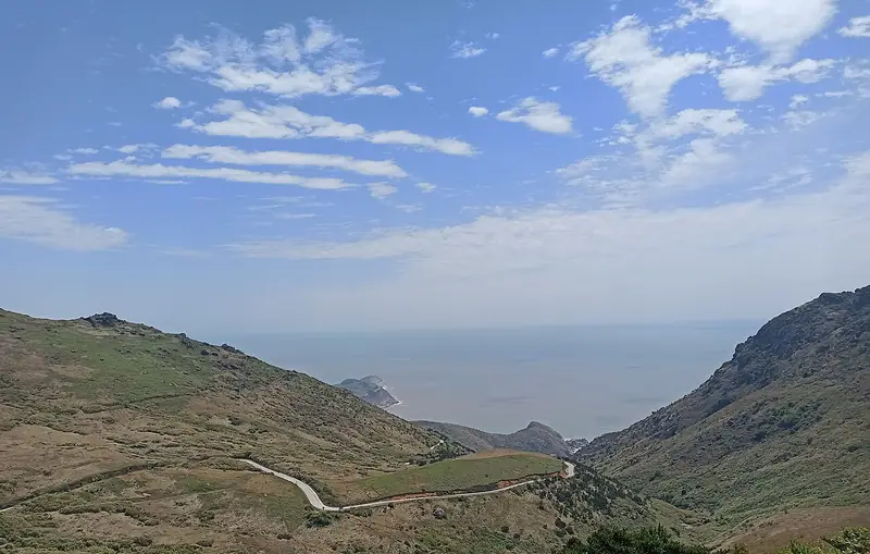 Yushan Island (嵛山岛), Fuding. Photograph: "Dayushan Island".
Yushan Island嵛山岛
Yushan Island (嵛山岛), in practice the main island Dayushan, lies in the sea south-east of Fuding in Ningde, Fujian, and is the largest island in eastern Fujian, known for the lakes and upland meadows on its summit.
Read the place guide → Bailin Ancient Town · 白琳古镇
Bailin Ancient Town白琳古镇
Bailin (白琳) is a tea town in Fuding, Ningde, Fujian; the "old town" of the catalogue is its flagstoned old street, a former tea market that has been restored as a tea-themed heritage street.
Read the place guide →Plan your visit
Getting there
Fuding is about 90 km in a straight line from central Ningde. Search for 福鼎市 in a map app to find stations and your accommodation.
Where to stay →Build your route
Mount Taimu and Yushan Island are both listed here. The linked place guides have entrance and visit details.
Continue with Ningde →More in Ningde
Sources & geographic information
Administrative names and parent areas: Official geographic directory · Reference date 2026-09-06.
Some facts checked against 福鼎市 — Wikipedia contributors, CC BY-SA 4.0.
Photo: Mount Taimu · rheins · CC BY 3.0. Full frame retained; proportionally resized and converted to WebP. No retouching or changes to the photographed subject. Card displays may crop the view.

Photo: Yushan Island · Perinbaba · CC BY 4.0. Full frame retained; EXIF orientation normalized, proportionally resized to at most 800 pixels and converted to WebP. No generated pixels or subject changes. Cards may crop the display.

Photo: Bailin Ancient Town · Source photographer · License not provided. EXIF orientation normalized; resized without changing aspect ratio; converted to WebP. No subject edits.
Map data © OpenStreetMap contributors. Pins mark approximate centres, not entrances or boundaries.