


Get to know Zhouning County
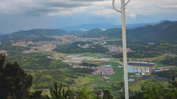
Photo adjustments
Full frame retained; proportionally resized and converted to WebP. No retouching or changes to the photographed subject. Card displays may crop the view.
- Administrative area
- County · 县
- Part of
- Ningde
- Chinese name
- 周宁县
- Local areas
- County guide
Area & population
- Area in the source
- 1,047.00 km²
- Population · 2020 census
- 149,567
Source: cited geographic source, as of the dates shown.
Setting and landscape
The county touches Fu'an (福安) to the east, Zhenghe (政和) to the west, Shouning (寿宁) to the north and Jiaocheng (蕉城) to the southeast, and faces Pingnan (屏南) across a stream to the southwest. The ground tilts from northwest to southeast through steep peaks and deep valleys: 282 summits pass 1,000 metres, the highest being Longgangtou (龙冈头) at 1,506 metres, while the lowest point, Jietouting (街头亭), is 65 metres.
Fifty-four streams run through the county; the Taoyuan (桃源溪), Houlong (后垄溪) and Zhoudun (周墩溪) are among six whose basins exceed 100 square kilometres. The climate is a mid-subtropical maritime monsoon mountain type with long winters and short summers; July averages 25.2°C, which earns the county the nickname "natural air-conditioned city". Forest covers 69.91% of the land, and the provincial Yiyang reserve (宜洋鸳鸯猕猴自然保护区) protects mandarin ducks and macaques.
History
In the early Song the area was Dongyang li (东洋里) of Ningde County. From 1556 a registrar from Ningde was posted here to collect taxes, and in 1735 part of Dongyang became a branch county. It was split from Ningde as the Zhoudun special district (周墩特种区) in 1935, and on 1 August 1945 a county named Zhouning was set up with its seat at Shicheng. In 1955 it gained 278.7 square kilometres, today's Siqiao (泗桥乡) and part of Chunchi (纯池镇), from Shouning. Locals speak Zhouning dialect, a form of Eastern Min they call Pinghua (平话).
What to see
The Jiulongji waterfalls (九龙漈瀑布群), southeast of the county town, drop in nine steps and joined the first list of Fujian provincial scenic areas in 1987. Together with the Carp Stream (鲤鱼溪) they form a national scenic area, a 4A site and the fourth park of the Ningde Global Geopark (宁德世界地质公园). The Carp Stream flows through Puyuan village (浦源村), whose people by custom do not eat the carp in it.
Chenqiao (陈峭), in Chenqiao village, is a 3A scenic area. The county government also lists Xianfeng Mountain (仙风山) provincial forest park, Qinshan Lake (芹山湖), the Houlongxi Grand Canyon (后垄溪大峡谷), Bat Cave (蝙蝠洞), Lingfeng Temple (灵峰寺) and Fangguang Temple (方广寺).
Getting oriented
Shicheng is 110 kilometres from central Ningde and 200 kilometres from Fuzhou (福州). The Quzhou–Ningde railway (衢宁铁路) crosses the county with a station at Xiancun (咸村镇), and national road G353 and the Ningde–Shangrao expressway (宁上高速) run through it.
Highlights
- Jiulongji waterfalls 九龙漈瀑布群: Nine-step waterfall group southeast of the county town; provincial scenic area since 1987.
- Carp Stream 鲤鱼溪: Stream in Puyuan village where villagers by custom do not eat the carp.
- Chenqiao scenic area 陈峭: 3A scenic area in Chenqiao village.
- Xianfeng Mountain 仙风山: Provincial forest park listed by the county government.
Sources for this guide
自然地理 · Zhouning County People's Government
自然资源 · Zhouning County People's Government
周宁县建制沿革信息 · Zhouning County People's Government (from Zhouning Yearbook 2023)
周宁县情概况 · Zhouning County People's Government
周宁县 - 维基百科,自由的百科全书 · Wikipedia (Chinese) · CC BY-SA 4.0
Original English written from the listed sources and checked sentence by sentence against quoted extracts by a separate reviewer. Updated 2026-09-23.
Explore Zhouning County
Core places to explore, with English and Chinese names.
Places to explore around Zhouning County
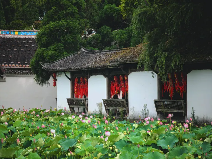 A lotus pond beside a traditional corridor pavilion at Liyu Xi (Carp Stream), Zhouning County ·
 Plan your visit
Getting there
Zhouning County is about 55 km in a straight line from central Ningde. Search for 周宁县 in a map app to find stations and your accommodation.
Where to stay →Build your route
Start with Carp Stream. The linked place guides have entrance and visit details.
Continue with Ningde →More in Ningde
Sources & geographic information
Administrative names and parent areas: Official geographic directory · Reference date 2026-09-06.
Some facts checked against 周宁县 — Wikipedia contributors, CC BY-SA 4.0.
Photo: Carp Stream · 明天放假 · CC BY-SA 4.0. Full frame retained; proportionally resized and converted to WebP. No retouching or changes to the photographed subject. Card displays may crop the view.

Map data © OpenStreetMap contributors. Pins mark approximate centres, not entrances or boundaries.