


Get to know Jiaocheng District
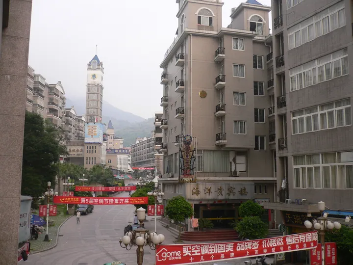
Photo adjustments
Full frame retained; proportionally resized and converted to WebP. No retouching or changes to the photographed subject. Card displays may crop the view.
- Administrative area
- District · 市辖区
- Part of
- Ningde
- Chinese name
- 蕉城区
- Local areas
- District guide
Area & population
- Area in the source
- 1,429.00 km²
- Population · 2020 census
- 623,840
Source: cited geographic source, as of the dates shown.
Setting and landscape
The land steps down in three tiers from west to east along the east slope of the Jiufeng range, in a shape the district government likens to a dustpan with a narrow mouth; the highest peak, Diyiqi (第一旗), reaches 1,479 m. The Huotong (霍童溪), Qidu (七都溪) and Dajin (大金溪) streams are among eight rivers that cross it. The district has 211 km of coastline and faces Xiapu (霞浦县) across the sea to the east.
Sandu Bay is narrow at the entrance and wide inside, with good shelter from wind; it is a natural deep-water harbour that ships of 500,000 tonnes can enter in any weather. The local speech is Ningde dialect (宁德话), a form of Eastern Min.
History
Between 836 and 840 land taken from Changxi (长溪) and Gutian (古田) counties became Gande (感德场), and in 933 it was raised to a county named Ningde by joining the first character of Ningchuan (宁川) with the second of Gande. In the mid-16th century wokou pirate raids (倭患) left the town in ruins. From 1561 magistrate Lin Shifang (林时芳) spent two years building a stone wall and new offices; the walled town was shaped like a banana leaf, which gave it the name Jiaocheng, 'banana-leaf town', and the old streets still follow that plan. In 1970 the prefectural government moved to Ningde.
What to see
Zhiti Mountain (支提山), a provincial scenic area, is regarded by Buddhists as 'the first Chan forest of sea and mountains', and its Huayan Temple (华严寺) is a national key Buddhist temple. Huotong Mountain (霍童山) is counted among the birthplaces of Taoist culture, and a stele inscribed 'Huotong Dongtian' (霍童洞天), granted by the Tang emperor Xuanzong (唐玄宗), still stands.
The Chinese She Palace (中华畲族宫) is a place of pilgrimage for She (畲族) people across China, and Jinhan She Ethnic Township (金涵畲族乡) has a She culture village. Huotong thread-lion puppetry (霍童线狮), She folk songs and the watertight-bulkhead shipbuilding of Zhangwan (漳湾) were on the first national intangible-heritage list.
Food and local products
Jiaocheng is called the home of large yellow croaker and of late-ripening longan; late longans and lychees were once court tribute. Other products are Tianshan green tea (天山绿茶), jasmine tea, swimming crab, laver, kelp, Erdu blood clams (二都蚶) and Anrui razor clams (安瑞蛏), along with two old crafts: Renyu scissors from Huotong (霍童仁宇剪刀) and Huang family bamboo steamers (黄家蒸笼).
Getting oriented
The Tongjiang–Sanya expressway (同三高速公路) and the Wenzhou–Fuzhou railway run north to south through the district; Ningde Station serves both the Wenzhou–Fuzhou and Quzhou–Ningde lines.
Highlights
- Sandu Bay 三都澳: Sheltered natural deep-water harbour with a narrow mouth and wide interior.
- Zhiti Mountain and Huayan Temple 支提山华严寺: Provincial scenic area; Huayan Temple is a national key Buddhist temple.
- Huotong Mountain 霍童山: Taoist site with a stele granted by Tang emperor Xuanzong.
- Chinese She Palace 中华畲族宫: Place of pilgrimage for She people across China.
Sources for this guide
蕉城概况 - 走进蕉城 · Jiaocheng District People's Government, Ningde
自然地理 - 走进蕉城 · Jiaocheng District People's Government, Ningde
人文历史 - 走进蕉城 · Jiaocheng District People's Government, Ningde
蕉城区 - 维基百科,自由的百科全书 · Wikipedia (Chinese) · CC BY-SA 4.0
Original English written from the listed sources and checked sentence by sentence against quoted extracts by a separate reviewer. Updated 2026-09-23.
Explore Jiaocheng District
Core places to explore, with English and Chinese names.
Jiaocheng District 蕉城区
Plan your visit
Getting there
Jiaocheng District covers the centre of Ningde. Search for 蕉城区 in a map app to find stations and your accommodation.
Where to stay →More in Ningde
Sources & geographic information
Administrative names and parent areas: Official geographic directory · Reference date 2026-09-06.
Some facts checked against 蕉城区 — Wikipedia contributors, CC BY-SA 4.0.
Map data © OpenStreetMap contributors. Pins mark approximate centres, not entrances or boundaries.