

Explore the region
Tap any red Chinese text to hear it in Mandarin.
Why visit
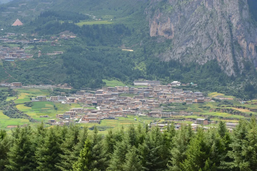
Zhagana is a village inside a mountain enclosure, not a single lookout detached from local life. The Gannan Tibetan Autonomous Prefecture government places it in Yiwa Township, Diebu County, 34 kilometres northwest of Diebu county seat. The same official description explains the Tibetan name as “stone box” and describes a natural stone-city setting, with rock walls, streams and traditional Tibetan village features.
The basin is easiest to understand from both levels. From above, the pale cliffs and forested slopes frame the fields and the houses below. On the ground, paths pass working homes, cultivated plots and streams; a 2022 China Tourism News report carried by the Ministry of Culture and Tourism describes the streams turning prayer wheels as they pass through the villages. The four named natural villages are Daiba, Yeri, Dari and Dongwa. A more recent Xinhua report identifies the Dari viewpoint and Xiannü Tan as distinct landscape stops, and describes the area as a high-elevation setting with forest, grassland and water features.
What to do
Begin with the inhabited lanes rather than rushing straight to a photo platform. Read the shape of the settlement: houses and fields occupy the basin floor while rock walls rise around it. Keep to public paths, leave working farmland and household yards undisturbed, and ask before photographing residents or entering a home. Prayer wheels and religious spaces are part of a living community, not props for a staged visit.
Then use the currently signed route to reach an open viewpoint. Dari viewpoint is the clearest named option in the sources for looking back over the villages. Xiannü Tan offers a different landscape setting. Treat these as separate stops, not as proof of a guaranteed short walking loop: the operator’s current trail, road and shuttle arrangements can change with weather and management.
The best visit leaves time for the scene to change. Morning haze can soften the enclosure; later light can separate the fields, houses and cliffs. At this elevation, keep a warm layer and allow extra time for uneven ground. Do not turn a village walk into an improvised high-mountain trek.
Getting there and back
Zhagana is a road destination in Yiwa Township. The prefectural government gives its position as 34 kilometres northwest of Diebu county seat, so the practical arrival is a pre-arranged road transfer, taxi or chartered car from Diebu rather than a rail connection. An English route guide also notes that Zhagana has no train station and is reached by road. Keep the Chinese name 扎尕那 Zhāgǎnà ready for map searches, and confirm the actual visitor entrance and parking arrangement for your date.
No reliable public-transport timetable or current internal-shuttle schedule was established in the sources used for this article. If you are not staying in the village, agree the return pickup before entering. A 2024 response published by the prefectural government confirmed severe peak-season congestion around the scenic area and said temporary traffic controls could be used, so do not assume that a late-day road departure will run to an unverified schedule.
Before setting out, check the operator’s current ticket or reservation requirement, entrance procedure, parking rules and any shuttle notice. Those operational details are date-sensitive and should not be inferred from older travel posts.
Stay on open routes
A county-government notice issued on 22 April 2026 prohibits tourism, trekking and other activities in unopened or undeveloped areas in Diebu. For Zhagana it explicitly includes the deep stone-forest area and grassland, as well as other unopened routes. The notice cites complex terrain, changing weather, limited facilities and difficult rescue conditions. Visit the formal village and viewpoint areas that are open on the day, follow signs and staff instructions, and do not follow an old “wild route” guide into closed terrain.
Winter road, trail and shuttle operation is not established by the official pages used here. Confirm those conditions locally before a cold-season visit, and arrange both the arrival and return rather than treating summer access information as year-round.
Combine your visit
A suggested order for the documented features and stops.
-
Village lanes
Begin with the houses and fields beneath the surrounding cliffs.
-
Dari viewpoint
Read the basin and village pattern from a higher vantage point.
-
Xiannü Tan
Add a different view of the mountain enclosure using the current authorised route.
This is an editorial sequence. Check access and any road or boat transfers; it does not establish a walking route, common ticket or guaranteed same-day connection.
Find Zhagana
扎尕那 · 迭部县
The pin marks the area, not the entrance.
More places nearby
Approximate straight-line distances between map pins, not travel distances.
Langmusi 郎木寺
53 km awayLangmusi occupies a high valley at the headwaters of the Bailong River, with monastery buildings rising on both sides of the provincial boundary. The Gansu side is associated with Sertri, or Saichi, Monastery; Kirti, or Ge’erdi…
View guide →Dangzhou Grassland Scenic Area 当周草原景区
84 km awayDangzhou Grassland combines an open meadow setting with developed visitor facilities on the southern edge of Hezuo. A Tibetan-style entrance decorated with auspicious motifs introduces paths, viewpoints and white-stupa features…
View guide →Milarepa Pavilion 米拉日巴佛阁
89 km awayMilarepa Pavilion is a tall, red-walled religious building within the Hezuo monastery precinct. Its vertically arranged shrines bring together figures associated with different Tibetan Buddhist traditions, while paintings and…
View guide →Sources & visit information
Sources checked on 1 November 2026. Hours, tickets, reservations and transport can change; confirm with the operator before you go.
Image credits & notes (1)
- A view over the inhabited settlement and cultivated fields in Zhagana Scenic Area, Diebu County, Gansu, photographed on 2 August 2026. Photo: JonashtandPhoto: CC BY-SA 4.0