


Get to know Têwo County
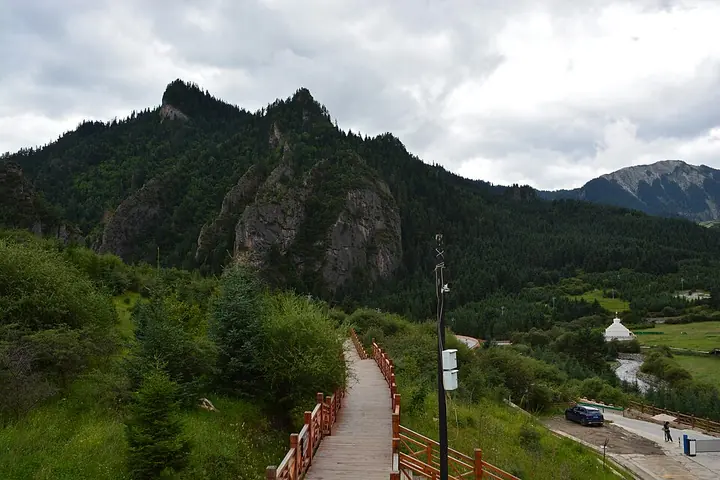
Photo adjustments
Full frame retained; proportionally resized and converted to WebP. No retouching or changes to the photographed subject. Card displays may crop the view.
- Administrative area
- County · 县
- Part of
- Gannan Tibetan Autonomous Prefecture
- Chinese name
- 迭部县
- Local areas
- County guide
Area & population
- Area in the source
- 5,108.30 km²
- Population · 2020
- 52,192
- Administrative seat
- Dêngga (Dianga)
Source: cited geographic source, as of the dates shown.
Setting and landscape
The Bailong River runs west to east through the county, with the Die range to its north and the Min range to its south. Sunny slopes carry grass and fields, while shaded slopes are covered in dense old-growth forest. Farmland lies mainly in the valley at about 1,600 to 1,800 metres; the main Die ridge rises to 4,488 metres, and nine lakes formed by collapse and damming sit among the peaks. Rare wildlife includes the giant panda and the snow leopard.
In Tibetan, Têwo means "thumb": a local story says a deity called Niegan Dawa (涅甘达娃) pushed a passage through the mountains here with his thumb.
History
In the Han period the area was known as Tazhong (沓中). The Shu Han general Jiang Wei (姜维) set up military farms here to keep away from his quarrel with the court eunuch Huang Hao (黄皓). Under the Republic it was part of the domain of the Yang family, the Tibetan chieftains of Choni (卓尼). The State Council approved the creation of Têwo County on 15 December 1961.
The Red Army's First, Second and Fourth Front Armies passed through in September 1935 and August 1936. At Ejie (俄界), now Gaoji village in Dala township (达拉乡), the Party Central Committee held the Ejie Meeting, and on 16 September 1935 troops under Yang Chengwu (杨成武) took the Lazikou Pass from the Nationalist blockhouses guarding it.
What to see
Zhagana (扎尕那), a village in Yiwa town (益哇镇), takes its name from a Tibetan phrase meaning "stone box". The explorer Joseph Rock collected plants in Têwo in the summer of 1925. Zhagana's mixed farming, forestry and herding system is listed by the Food and Agriculture Organization as a Globally Important Agricultural Heritage System, and in 2023 the village was named one of UN Tourism's Best Tourism Villages.
Lazikou (腊子口) is a pass in the Min Mountains on the route between northern Sichuan and southern Gansu. The Ejie Meeting site and Mao Zedong's former lodging in Dacirina village (达茨日那村), where he directed the Lazikou battle, are destinations for red tourism, travel to Communist revolutionary sites. The county also has 23 Tibetan Buddhist monasteries of the Gelug, Sakya and Bon traditions, and archaeological sites of the Majiayao, Qijia and Siwa cultures.
Food and local products
Juema pork (蕨麻猪肉) from Têwo has been chosen as one of ten leading agricultural-heritage brands. Other local brands include Ni'ao black fungus (尼傲黑木耳), Cirina apples (茨日那苹果) and highland barley liquor from Zhagana, and wild morels grow in the county.
Highlights
- Zhagana 扎尕那: Village whose name means 'stone box'; its farming-forestry-herding system is a FAO agricultural heritage site.
- Lazikou Pass 腊子口: Min Mountains pass taken by Red Army troops on 16 September 1935.
- Ejie Meeting site 俄界会议旧址: Place of the 1935 party meeting, now Gaoji village in Dala township.
- Juema pork 蕨麻猪肉: Meat of the local juema pig, chosen as one of ten leading agricultural-heritage brands.
Sources for this guide
自然地理-迭部县人民政府 · Têwo County People's Government
县情简介-迭部县人民政府 · Têwo County People's Government
历史沿革-迭部县人民政府 · Têwo County People's Government
迭部县 - 维基百科,自由的百科全书 · Wikipedia (Chinese) · CC BY-SA 4.0
扎尕那 - 维基百科,自由的百科全书 · Wikipedia (Chinese) · CC BY-SA 4.0
腊子口 - 维基百科,自由的百科全书 · Wikipedia (Chinese) · CC BY-SA 4.0
Original English written from the listed sources and checked sentence by sentence against quoted extracts by a separate reviewer. Updated 2026-09-23.
Explore Têwo County
Core places to explore, with English and Chinese names.
Places to explore around Têwo County
A path among the cliffs at Zhagana · 扎尕那 Photograph date recorded by the source: 2 August 2026, 14:57:08.Zhagana扎尕那
Zhagana’s villages sit beneath an enclosure of pale limestone peaks, with forested slopes, fields and Tibetan houses filling the basin below. The setting becomes clearer as you move between the inhabited lanes and the designated…
Read the place guide →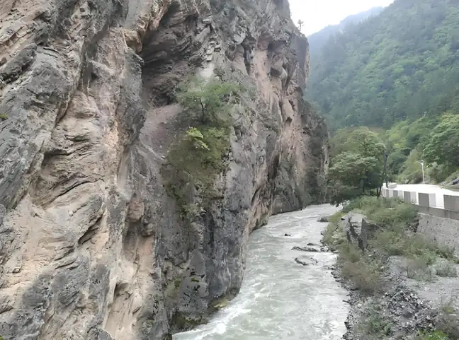 Lazikou Pass · 腊子口
Lazikou Pass腊子口
Langzha Pass (腊子口) is a narrow gorge pass in the mountains of north-eastern Têwo county, Gannan Tibetan Autonomous Prefecture, Gansu, listed as a national AAA-grade tourist attraction and also the memorial place of the Langzha Pass battle.
Read the place guide →Plan your visit
Getting there
Têwo County is about 105 km in a straight line from central Gannan Tibetan Autonomous Prefecture. Search for 迭部县 in a map app to find stations and your accommodation.
Where to stay →Build your route
Zhagana and Lazikou Pass are both listed here. The linked place guides have entrance and visit details.
Continue with Gannan Tibetan Autonomous Prefecture →More in Gannan Tibetan Autonomous Prefecture
Sources & geographic information
Administrative names and parent areas: Official geographic directory · Reference date 2026-09-06.
Some facts checked against 迭部县 — Wikipedia contributors, CC BY-SA 4.0.
Some facts checked against 扎尕那 — Wikipedia contributors, CC BY-SA 4.0.
Some facts checked against 腊子口 — Wikipedia contributors, CC BY-SA 4.0.
Photo: Zhagana · Jonashtand · CC BY-SA 4.0. Full frame retained; proportionally resized and converted to WebP. No retouching or changes to the photographed subject. Card displays may crop the view.

Photo: Lazikou Pass · Source photographer · License not provided. EXIF orientation normalized; resized without changing aspect ratio; converted to WebP. No subject edits.
Map data © OpenStreetMap contributors. Pins mark approximate centres, not entrances or boundaries.