


Get to know Ningming County
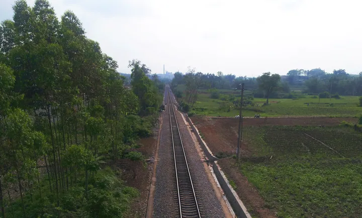
Photo adjustments
Full frame retained; proportionally resized and converted to WebP. No retouching or changes to the photographed subject. Card displays may crop the view.
- Administrative area
- County · 县
- Part of
- Chongzuo
- Chinese name
- 宁明县
- Local areas
- County guide
Area & population
- Area in the source
- 3,779.00 km²
- Population · 2020
- 319,386
- Administrative seat
- Chengzhong (城中镇)
Source: cited geographic source, as of the dates shown.
Setting and landscape
The county lies south of the Tropic of Cancer. Fangchenggang (防城港) and Shangsi County (上思县) are to the east, Vietnam to the south, Pingxiang (凭祥) and Longzhou County (龙州县) to the west, and urban Chongzuo and Fusui County (扶绥县) to the north. The southeast is steep earthen upland, with Pulong Mountain (浦龙山) reaching 1,358 metres; the north has karst hills. In the north-centre the valley plain of the Ming River crosses the county from east to west, covering about 1,000 square kilometres at 109 to 200 metres above sea level.
The climate is subtropical monsoon with distinct wet and dry seasons. June to August brings the heaviest rain and frequent typhoons; from November the northerly winter monsoon brings cooler, drier weather. The county government calls Ningming a home of rosin and of star anise ("中国松香之乡、八角之乡").
History
In 214 BC the area belonged to the Qin dynasty's Xiang Commandery (象郡), and from 111 BC it formed part of Linchen (临尘) and Yongji (雍鸡) counties under Yulin Commandery (郁林郡). Under the Qing it was part of Taiping Prefecture (太平府). It has been a county of Chongzuo since 2003. The county's own list of ten views includes the old frontier forts (边关炮台), the Qianlong Academy (迁隆书院) and the Yongping ancient tombs (永平古墓).
What to see
The Huashan Rock Art scenic area lies in the Ming River valley about 8 kilometres northwest of the county town. It is on the World Heritage List and rated a national 5A scenic area; the county government describes it as China's first rock-art World Heritage site and Guangxi's first world cultural heritage site. Four painted cliffs survive there, at Huashan, Gaoshan (高山), Longxiashan (龙峡山) and Zhushan (珠山), all national protected sites. Boat tours run in the scenic area, which also stages folk performances and traditional brown-sugar making.
Paiyangshan Forest Park (派阳山森林公园), a 4A scenic area, covers 1,341.84 hectares of forest with a lake for boating and fishing. Shizitou Forest Park (狮子头森林公园) at Nacai village in Haiyuan town (海渊镇), 68 kilometres from the county town, holds the Hongde Temple (弘德庙) and Hong'en Temple (弘恩寺), first built in the Kangxi reign of the Qing.
Getting oriented
The county town is 156 kilometres from Nanning (南宁), or 188 kilometres by road. The Hunan–Guangxi Railway (湘桂铁路), the Nanning–Youyiguan Expressway (南友高速公路) and National Highway 322 run through the county. Aidian (爱店) is a first-class national port on the border with Vietnam.
Highlights
- Huashan Rock Art 花山岩画: World Heritage rock paintings in the Ming River valley, about 8 km northwest of the county town, with boat tours.
- Paiyangshan Forest Park 派阳山森林公园: 4A forest park of 1,341.84 hectares with a lake for boating and fishing.
- Shizitou Forest Park 狮子头森林公园: Forest park in Haiyuan town with the Hongde and Hong'en temples, first built in the Kangxi reign.
- Gongmu Mountain 公母山: Mountain straddling the China–Vietnam border.
Sources for this guide
宁明概况 - 广西崇左市宁明县人民政府门户网站 · Ningming County People's Government
宁明国家级旅游景区 - 广西崇左市宁明县人民政府门户网站 · Ningming County Bureau of Culture, Tourism, Sports and Broadcasting
建置沿革 - 广西崇左市宁明县人民政府门户网站 · Ningming County People's Government
自然地理 - 广西崇左市宁明县人民政府门户网站 · Ningming County People's Government
Original English written from the listed sources and checked sentence by sentence against quoted extracts by a separate reviewer. Updated 2026-09-24.
Explore Ningming County
Core places to explore, with English and Chinese names.
Places to explore around Ningming County
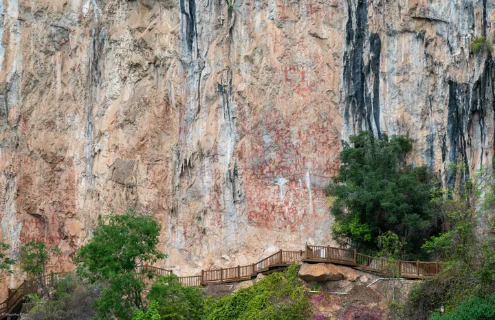 Red ochre rock paintings on the limestone cliff face of Huashan Rock Art, with a viewing boardwalk, Ningming County, Chongzuo ·
 Plan your visit
Getting there
Ningming County is about 40 km in a straight line from central Chongzuo. Search for 宁明县 in a map app to find stations and your accommodation.
Where to stay →Build your route
Start with Huashan Rock Art. The linked place guides have entrance and visit details.
Continue with Chongzuo →More in Chongzuo
Sources & geographic information
Administrative names and parent areas: Official geographic directory · Reference date 2026-09-06.
Photo: Huashan Rock Art · xiquinhosilva · CC BY 2.0. Full frame retained; proportionally resized and converted to WebP. No retouching or changes to the photographed subject. Card displays may crop the view.
.jpg)
Map data © OpenStreetMap contributors. Pins mark approximate centres, not entrances or boundaries.