


Get to know Pingxiang
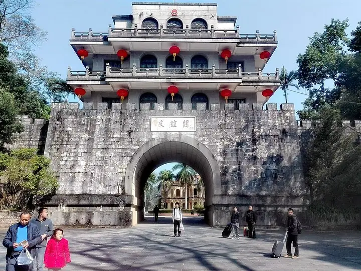
Photo adjustments
The exact downloaded source bytes are separately retained and hashed. Prepared JPEG is proportionally reduced to a maximum 720-pixel long edge; full frame retained, no subject alteration. Final website rendition: full frame retained, proportionally resized to at most 720 pixels and converted to WebP. No additional retouching or subject alteration. Card displays may crop the view.
- Administrative area
- County-level city · 县级市
- Part of
- Chongzuo
- Chinese name
- 凭祥市
- Local areas
- County-level city guide
Area & population
- Area in the source
- 650.00 km²
- Population · 2020
- 129,843
- Administrative seat
- Pingxiang
Source: cited geographic source, as of the dates shown.
History
Under the Qin the area belonged to Xiang Commandery (象郡), and the name Pingxiang dates from the Pingxiang settlement (凭祥峒) set up under the Northern Song. Pingxiang became a city in November 1956, the fifth in Guangxi; in June 1992 it became an open border city.
The pass itself dates from the Han dynasty and has changed names several times: Yongji Pass (雍鸡关), Zhennan Pass (镇南关) from the early Ming, and Friendship Pass since 1965. In 1885 the Qing general Feng Zicai (冯子材) defeated French forces here; in December 1907 Sun Yat-sen (孙中山) led the Zhennan Pass Uprising on Jinji Mountain (金鸡山), the only one of his ten uprisings in which he took part in the fighting. On 11 December 1949 the People's Liberation Army raised its flag at the pass, marking the liberation of Guangxi, and the date became the region's anniversary day.
What to see
Friendship Pass, a 4A scenic area and national protected site, lies on the border 15 kilometres from the city centre. Its gate tower was rebuilt in 1957. Around it stand a Ming-era fort on Zuobi Mountain (左弼山), the French-style building that housed the late-Qing border affairs office, and, about 400 metres north, the mass grave of Qing soldiers killed in the Sino-French War.
Jinji Mountain, on the right of the gate tower, rises to 596 metres and was listed as a national protected site in June 2006. Its three forts were built under the Qing commander Su Yuanchun (苏元春) and completed in 1895, with Krupp guns hauled up the mountain; the northern fort's gun, made in 1891, is still in place. The city government also lists the Dalian Fort (大连城), the underground defences of Pinggangling (平岗岭地下长城), a redwood-furniture market (红木文博城) and the Ping'er River (平而河) border river among its sights.
Setting and landscape
Pingxiang lies south of the Tropic of Cancer and has a hot, wet subtropical monsoon climate, with summer lasting from mid April to mid October and most rain from June to August. Its largest river, the Ping'er, rises in northern Vietnam, enters China at Ping'er Pass and flows on towards Longzhou (龙州) to join the Zuo River (左江).
Getting oriented
Friendship Pass is 176 kilometres from Nanning (南宁), 18 kilometres from Lang Son (谅山) in Vietnam and 170 kilometres from Hanoi. The city has two international crossings, the Friendship Pass road port and the Pingxiang railway port. The Hunan–Guangxi Railway (湘桂铁路) and National Highway 322 cross the city.
Highlights
- Friendship Pass 友谊关: Han-era border pass still in use; 4A scenic area and national protected site, 15 km from the city centre.
- Jinji Mountain forts 金鸡山炮台: Three Qing forts completed in 1895 with Krupp guns; site of Sun Yat-sen's 1907 uprising; national protected site since 2006.
- Dalian Fort 大连城: Historic site listed by the city government among its main sights; a provincial-level protected site.
- Ping'er River 平而河: Border river that enters China from Vietnam at Ping'er Pass and flows towards Longzhou.
Sources for this guide
凭祥简介 - 凭祥市人民政府门户网站 · Pingxiang City People's Government
友谊关景区简介 - 凭祥市人民政府门户网站 · Pingxiang City People's Government
凭祥历史沿革 - 凭祥市人民政府门户网站 · Pingxiang City People's Government
凭祥自然地理 - 凭祥市人民政府门户网站 · Pingxiang City People's Government
金鸡山 - 凭祥市人民政府门户网站 · Pingxiang City People's Government
Original English written from the listed sources and checked sentence by sentence against quoted extracts by a separate reviewer. Updated 2026-09-24.
Explore Pingxiang
Core places to explore, with English and Chinese names.
Places to explore around Pingxiang
Plan your visit
Getting there
Pingxiang is about 70 km in a straight line from central Chongzuo. Search for 凭祥市 in a map app to find stations and your accommodation.
Where to stay →Build your route
Start with Friendship Pass. The linked place guides have entrance and visit details.
Continue with Chongzuo →More in Chongzuo
Sources & geographic information
Administrative names and parent areas: Official geographic directory · Reference date 2026-09-06.
Photo: Friendship Pass · TSVC1190 · TSVC1190 — The_main_gate_of_Friendship_Pass_in_China.jpg — CC BY-SA 4.0 · CC BY-SA 4.0. The exact downloaded source bytes are separately retained and hashed. Prepared JPEG is proportionally reduced to a maximum 720-pixel long edge; full frame retained, no subject alteration. Final website rendition: full frame retained, proportionally resized to at most 720 pixels and converted to WebP. No additional retouching or subject alteration. Card displays may crop the view.

Map data © OpenStreetMap contributors. Pins mark approximate centres, not entrances or boundaries.