


Get to know Xiangzhou County

- Administrative area
- County · 县
- Part of
- Laibin
- Chinese name
- 象州县
- Local areas
- County guide
Area & population
- Area in the source
- 1,898.00 km²
- Population · 2020
- 281,846
- Administrative seat
- Xiangzhou Town
Source: cited geographic source, as of the dates shown.
Setting and landscape
The land rises to the east, where steep middle and low mountains of 500 to 1,000 m line the county's edge; the centre and north are plains and hills of 100 to 200 m, and the west is karst country of crowded peaks and frequent caves. Twelve main rivers run down from the Dayaoshan and feed the Liu in a branching pattern; only the Qingling River (青凌河) flows west to the Hongshui. The Yun River (运江) runs 63.75 km through the county.
History
Administration here began in 111 BC, when the Han set up Guilin County (桂林县). Under the Liang dynasty Yangshou (阳寿), today's county town, became a commandery seat, and in 592 the Sui created Xiangzhou prefecture (象州), which the Tang revived in 621 with its seat at Yangshou. In 1856 the Dacheng rebels under Li Wenmao (李文茂) took the town and renamed it Xiangzhou (相州), written with a different character, until the Qing retook it. It became Xiang County in 1912; in 1952 it was merged with Wuxuan as Shilong County (石龙县), which took the name Xiangzhou County in 1960, and the seat moved to Xiangzhou town in 1962.
What to see
The county's hot spring, visited at the Guxiang Hot Spring scenic area (古象温泉), is promoted locally as "the first spring of south-central China". Nalu village (纳禄村) in Luoxiu town (罗秀镇) keeps Ming and Qing buildings; China.com.cn calls it the home of descendants of the Ming princes of Jingjiang (靖江王), a "caidiao village" for the Guangxi folk opera (彩调), a listed Chinese traditional village and a 3A scenic area. The county also promotes Yunjiang old town (运江古镇) as a historic trading port and Baishi village (白石村) for Zheng Xiaogu (郑小谷), honoured as a master of both Guangdong and Guangxi, whose former residence the county names among its main sights.
Food and local products
Gupa tea (古琶茶) and Xiangzhou shatangju mandarins (象州沙糖桔) are national geographical-indication farm products, and Sigao village (思高村) in Miaohuang (妙皇) builds on the Gupa tea technique, which is on the autonomous-region intangible-heritage list. Xiangzhou roasted sweet-potato strips and the Liao family's mutton from Maping (马坪廖氏羊肉) won prizes at an autonomous-region contest for intangible-heritage foods.
Getting oriented
The county seat is Xiangzhou town. Jinxiu lies to the east, Wuxuan to the south, Luzhai to the north, and Liuzhou's Liujiang district and Laibin's Xingbin district to the west. National Roads 209 and 355 and the Liuzhou–Wuxuan and Wuzhou–Liuzhou expressways cross the county.
Highlights
- Guxiang Hot Spring 古象温泉: Hot-spring scenic area promoted as the first spring of south-central China.
- Nalu village 纳禄村: Ming and Qing buildings linked to descendants of the Jingjiang princes; caidiao opera village and 3A area.
- Yunjiang old town 运江古镇: Old trading port town on the county's tourism list.
- Gupa tea 古琶茶: National geographical-indication tea whose technique is on the autonomous-region heritage list.
Sources for this guide
象州县概况 · Xiangzhou County People's Government
象州历史沿革 · Xiangzhou County People's Government
【地理环境】 · Xiangzhou County People's Government
【水文】 · Xiangzhou County People's Government
文旅融合迸发新活力 · China.com.cn (Guangxi channel)
来宾市象州:全域旅游让乡村重焕生机 · Guangxi Daily (via China Radio International)
Original English written from the listed sources and checked sentence by sentence against quoted extracts by a separate reviewer. Updated 2026-09-24.
Explore Xiangzhou County
Core places to explore, with English and Chinese names.
Places to explore around Xiangzhou County
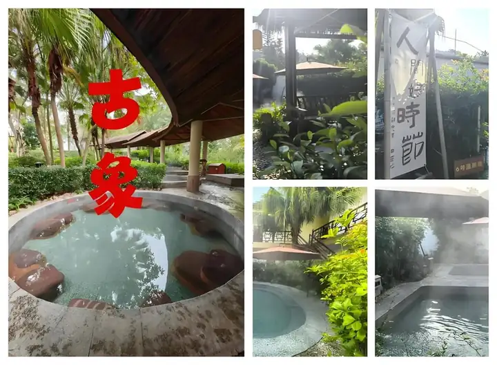 Guxiang Hot Spring ·
 Plan your visit
Getting there
Xiangzhou County is about 50 km in a straight line from central Laibin. Search for 象州县 in a map app to find stations and your accommodation.
Where to stay →Build your route
Start with Guxiang Hot Spring. The linked place guides have entrance and visit details.
Continue with Laibin →More in Laibin
Sources & geographic information
Administrative names and parent areas: Official geographic directory · Reference date 2026-09-06.
Photo: Guxiang Hot Spring · Source photographer · License not provided. EXIF orientation normalized; resized without changing aspect ratio; converted to WebP. No subject edits.
Map data © OpenStreetMap contributors. Pins mark approximate centres, not entrances or boundaries.