


Get to know Tengxian
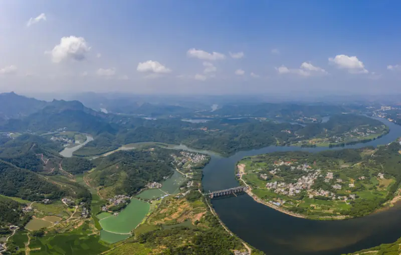
Photo adjustments
EXIF orientation normalized; resized without changing aspect ratio; converted to WebP. No subject edits.
- Administrative area
- County · 县
- Part of
- Wuzhou
- Chinese name
- 藤县
- Local areas
- County guide
Area & population
- Area in the source
- 3,945.62 km²
- Population · 2021
- 1,125,264
- Administrative seat
- Tengzhou (藤州镇)
Source: cited geographic source, as of the dates shown.
Setting and landscape
The county measures 112 kilometres from north to south and 86 kilometres from east to west, with narrow alluvial plains along the rivers; most rivers run north or south. Five townships, Ningkang (宁康), Dali (大黎), Dongrong (东荣), Pingfu (平福) and Gulong (古龙), have a mid-subtropical monsoon climate, and the rest of the county a south-subtropical one. The Meng River (蒙江) valley around Taiping (太平) and Dongrong is warmer and damper than the rest of the north.
History
In 589 the Sui renamed Shizhou (石州) as Tengzhou (藤州), and the county takes its name from that prefecture. The "Lingwai Daida" (岭外代答) explains the name by a very large old vine (teng) outside the prefectural seat; the county government also records an account linking it to Baiteng Ridge (白藤岭). The prefecture seat, Xinjin County (镡津县), was moved to the site of the present county town during the Kaibao years (968–975). Tengzhou was reduced to Tengxian in 1377 under the Ming, and it has been part of Wuzhou since April 1997.
What to see
Shibiaoshan (石表山) is a national 4A scenic area of Danxia landforms. Daojia village (道家村), a national key rural tourism village, keeps Ming and Qing buildings including the Fulong manor (福隆庄), Sizhi Hall (四知堂), Tongji Bridge (通济桥) and Xie Jin Pavilion (解缙亭). Xinma village (新马村), home village of the patriotic hero Yuan Chonghuan (袁崇焕), is a 3A scenic area with a memorial hall, the site of his former home and the He family ancestral hall. The Tengxian Museum (藤县博物馆) covers local history, Guabang Ridge Park (挂榜岭公园) has a summit lookout over the whole town, and Taochun Garden (陶春园) centres on Liubao tea (六堡茶) and Teng porcelain (藤瓷), with pottery and tea-making sessions.
Traditions
Tengxian is known as a "home of lion dancing", and the Tengxian lion dance (藤县狮舞) has been on the national intangible-heritage list since 2011. It comes in two forms: the ground-based "caiqing" lion (采青狮), which plucks greens, and the "high-pole" lion (高桩狮), performed on top of posts.
Getting oriented
The county seat is Tengzhou town (藤州镇). By road it is 78 kilometres east to Wuzhou and 350 kilometres west to Nanning. Tengxian station on the Nanning–Guangzhou railway (南广铁路) lies about 20 kilometres from the county town.
Highlights
- Shibiaoshan 石表山: National 4A scenic area of Danxia landforms.
- Daojia village 道家村: Village with Ming and Qing buildings including Fulong manor, Sizhi Hall and Tongji Bridge.
- Yuan Chonghuan's home village, Xinma 新马村袁崇焕故里: 3A scenic area with a memorial hall, his former home site and the He family ancestral hall.
- Tengxian lion dance 藤县狮舞: National intangible heritage since 2011, performed as ground-based caiqing lion and high-pole lion.
- Taochun Garden 陶春园: Centre for Liubao tea and Teng porcelain with pottery and tea-making sessions.
Sources for this guide
历史沿革 - 藤县人民政府门户网站 · Tengxian People's Government
自然地理 - 藤县人民政府门户网站 · Tengxian People's Government
五一游藤县|4条精品线路任选 - 藤县人民政府门户网站 · Tengxian People's Government
狮舞(藤县狮舞) - 中国非物质文化遗产网 · China Intangible Cultural Heritage Network (Chinese National Academy of Arts)
藤县 - 维基百科 · Wikipedia (Chinese) · CC BY-SA 4.0
Original English written from the listed sources and checked sentence by sentence against quoted extracts by a separate reviewer. Updated 2026-09-24.
Explore Tengxian
Core places to explore, with English and Chinese names.
Plan your visit
Getting there
Tengxian is about 40 km in a straight line from central Wuzhou. Search for 藤县 in a map app to find stations and your accommodation.
Where to stay →More in Wuzhou
Sources & geographic information
Administrative names and parent areas: Official geographic directory · Reference date 2026-09-06.
Some facts checked against 藤县 — Wikipedia contributors, CC BY-SA 4.0.
Map data © OpenStreetMap contributors. Pins mark approximate centres, not entrances or boundaries.