


Get to know Huaxi District

Photo adjustments
Full frame retained; proportionally resized and converted to WebP. No retouching or changes to the photographed subject. Card displays may crop the view.
- Administrative area
- District · 市辖区
- Part of
- Guiyang City
- Chinese name
- 花溪区
- Local areas
- District guide
Area & population
- Area in the source
- 957.60 km²
- Population · 2010
- 608,213
Source: cited geographic source, as of the dates shown.
Setting and landscape
The district lies on the eastern slope of the Yunnan–Guizhou Plateau and the middle stretch of the Miaoling (苗岭) range. The watershed runs from Jiupan (旧盘) and Zhangke (掌克) to Tongmuling (桐木岭) and Shangban (上板) in Mengguan (孟关); north of this line the Huaxi River (花溪河) and seven other rivers drain to the Yangtze, while the Maling (马铃河), Qingyan (青岩河) and seven more rivers flow south to the Pearl River system. Huaxi Reservoir (花溪水库) and Aha Reservoir (阿哈水库) are the two medium-sized reservoirs. Rare trees recorded here include the yew, the ginkgo and the Qingyan keteleeria (青岩油杉).
History
In July 1942 the seat of Guizhu County (贵筑县) moved to the south foot of Panlong Mountain (蟠龙山) on the north bank of the Huaxi River, and Huaxi remained the county seat until February 1958. That month Guizhu County was abolished and Guiyang's suburbs were split along the Guizhou–Yunnan and Guizhou–Guangxi highways: the land to the south became Huaxi District. In 2012 the former Xiaohe District (小河区) was merged in to form the present district.
What to see
The district government names the Shili Hetan (十里河滩) national urban wetland park, the Confucian academy Kongxuetang (孔学堂), Huaxi Park (花溪公园), Tianhetan (天河潭), Qingyan Ancient Town (青岩古镇) and the Miao township of Gaopo (高坡) as its best-known sights. Qingyan Ancient Town is a national 5A-rated tourist area and Tianhetan a 4A area. Guizhou University and Guizhou Minzu University are also in the district.
Miao and Buyi festivals follow the lunar calendar: the Miao "tiaodong" (跳洞, cave dance) at Shanping (杉坪) in Gaopo on the fourth day of the first month, a Buyi ground-opera (地戏) performance at Huaxi Dazhai (花溪大寨) on the fifteenth, and a Buyi song gathering in Huaxi Park on the sixth day of the sixth month. Mengguan also holds Miao bullfighting contests.
Food and local products
The best-known local snacks are Huaxi beef rice noodles (花溪牛肉粉), Qingyan braised pig's trotters (青岩卤猪脚), chicken with chillies (鸡辣椒), gaoba rice-cake porridge (糕粑稀饭), rice tofu (米豆腐) and roxburgh-rose glutinous rice wine (刺梨糯米酒).
Highlights
- Qingyan Ancient Town 青岩古镇: National 5A-rated tourist area.
- Tianhetan 天河潭: National 4A-rated scenic area.
- Shili Hetan 十里河滩: National urban wetland park named by the district government among its best-known sights.
- Huaxi beef rice noodles 花溪牛肉粉: Listed first among Huaxi's best-known snacks.
Sources for this guide
花溪区人民政府门户网站-花溪概况 · Huaxi District People's Government, Guiyang
花溪区人民政府门户网站-自然地理 · Huaxi District People's Government, Guiyang
花溪区人民政府门户网站-历史沿革 · Huaxi District People's Government, Guiyang
Original English written from the listed sources and checked sentence by sentence against quoted extracts by a separate reviewer. Updated 2026-09-25.
Explore Huaxi District
Core places to explore, with English and Chinese names.
Places to explore around Huaxi District
 Karst cliffs and a lake at Tianhetan scenic area, Huaxi District, Guiyang · 贵阳花溪区天河潭风景区 Source-recorded photograph date: Taken on 4 July 2015.
Tianhetan天河潭
Tianhetan combines water-filled caves, channels and a waterfall landscape in Guiyang’s Huaxi district. The cascade passes through a narrow rock opening, while the cave route reveals the underground side of the karst terrain…
Read the place guide → Qingyan Ancient Town · 青岩古镇
Qingyan青岩古镇
Qingyan’s old-town visit can be organised around its gates and historic civic buildings. Dingguang Gate and the North Gate mark the fortified settlement, while Wenchang Pavilion and the former residence of Zhao Yijiong provide…
Read the place guide →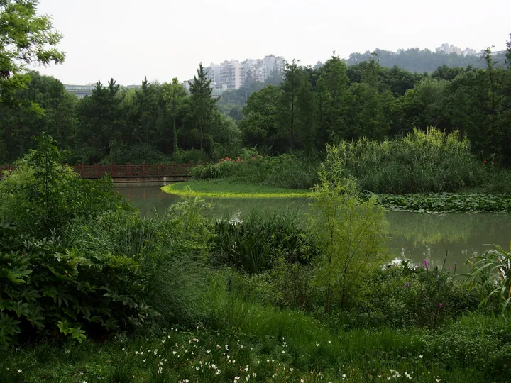 A leafy wetland park: a still green lake with lily pads and a wooded bank, a red-railed timber bridge crossing at the left, tall reeds and grasses with white flowers in the foreground, and a row of white apartment blocks on the ridge behind.
Huaxi Park and Shili Hetan Wetland花溪公园与十里河滩
Huaxi Park is a city park in Huaxi District, Guiyang, strung on the Huaxi river, and the Shili Hetan is one of the features that river links to it; the forestry bureau lists the two separately within the Huaxi provincial scenic and historic area.
Read the place guide → Gaopo Miao Township · 高坡苗乡
Gaopo Miao Township高坡苗乡
Gaopo is a Miao township in Huaxi District, Guiyang; the Huaxi provincial scenic and historic area is divided into four scenic areas, a scenic group and an independent site, and one of the four scenic areas is named Gaopo Yunding.
Read the place guide →Plan your visit
Getting there
Huaxi District is about 25 km in a straight line from central Guiyang City. Search for 花溪区 in a map app to find stations and your accommodation.
Where to stay →Build your route
Tianhetan and Qingyan are about 15 km apart in a straight line. The linked place guides have entrance and visit details.
Continue with Guiyang City →More in Guiyang City
Sources & geographic information
Administrative names and parent areas: Official geographic directory · Reference date 2026-09-06.
Photo: Tianhetan · rheins · CC BY 3.0. Full frame retained; proportionally resized and converted to WebP. No retouching or changes to the photographed subject. Card displays may crop the view.

Photo: Qingyan · Harry Alverson · CC BY-SA 2.0. Wikimedia thumbnail; fitted to the ranking-card frame.

Photo: Huaxi Park and Shili Hetan Wetland · rheins · CC BY 3.0. Full frame retained; proportionally resized and converted to WebP. No retouching or changes to the photographed subject. Card displays may crop the view.

Photo: Gaopo Miao Township · Source photographer · License not provided. EXIF orientation normalized; resized without changing aspect ratio; converted to WebP. No subject edits.
Map data © OpenStreetMap contributors. Pins mark approximate centres, not entrances or boundaries.