


Get to know Caofeidian District
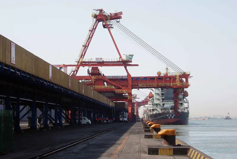
Photo adjustments
EXIF orientation normalized; resized without changing aspect ratio; converted to WebP. No subject edits.
- Administrative area
- District · 市辖区
- Part of
- Tangshan
- Chinese name
- 曹妃甸区
- Local areas
- District guide
Area & population
- Population · 2020 census
- 352,100
- Administrative seat
- Tanghai
Source: cited geographic source, as of the dates shown.
Setting and landscape
The district is mostly plain that falls gently from north to south. Its northern edge is the tail of the lower Luan River (滦河) alluvial fan; the south is land left behind by the retreating sea, shaped by coastal currents, tides and living organisms. The climate is temperate and semi-humid with a marked continental monsoon, an average of 11°C and about 636 mm of rain a year.
Caofeidian Island itself is a strip of sand that formed on the front of the old Luan delta as the river shifted north, about 20 kilometres off the mainland shore. Within 500 to 600 metres of its head the water is 20 to 30 metres deep, which makes it a natural deep-water harbour; the district government says the port stays free of ice and silt all year, and a 400,000-tonne ore carrier first docked here in November 2015. Its name comes from a legend that a consort surnamed Cao died here during an eastern campaign of Emperor Taizong of Tang, and a temple built for her gave the island its name.
What to see
The Caofeidian Wetland (曹妃甸湿地) covers 540 square kilometres, is a national 4A scenic area and is a stopover for rare migratory birds. Dragon Island (龙岛), an island off the coast, has fine sand, surf and gulls. Lanyuewan (揽月湾) is a 4A scenic area that hosts a beach music festival, and Duoma Park (多玛乐园) is a fishing-culture theme park where visitors catch crabs and dig clams. A 27-kilometre scenic road built by the district ties the scattered coastal attractions together.
Several of the district's township-level units are numbered state farms and aquaculture farms; the district government describes Caofeidian as home to the country's second-largest state farm, known for water-based agriculture.
Food and local products
The Shilihai aquaculture farm (十里海养殖场), which the district government says leads the country in pufferfish (河豚) farming techniques, holds an International Pufferfish Festival; Pufferfish Town (河豚小镇) there combines pufferfish restaurants with a leisure fishing complex. Caofeidian also has salt works that the district government describes as the largest in Asia, producing two million tonnes of raw salt a year.
Highlights
- Caofeidian Wetland 曹妃甸湿地: 540 km² wetland, a national 4A scenic area on a migration route for rare birds.
- Dragon Island 龙岛: Sea island with fine sand, surf and gulls.
- Lanyuewan 揽月湾: 4A scenic area that hosts a beach music festival.
- Pufferfish Town 河豚小镇: Pufferfish restaurants and leisure fishing at the Shilihai aquaculture farm.
Sources for this guide
曹妃甸区情概述--曹妃甸区人民政府 · Caofeidian District People's Government, Tangshan
自然地理--曹妃甸区人民政府 · Caofeidian District People's Government, Tangshan
曹妃甸生态观光旅游路:串起滨海好风光 激活发展新动能--曹妃甸区人民政府 · Caofeidian District People's Government, Tangshan
曹妃甸区 - 维基百科,自由的百科全书 · Wikipedia (Chinese) · CC BY-SA 4.0
Original English written from the listed sources and checked sentence by sentence against quoted extracts by a separate reviewer. Updated 2026-09-24.
Explore Caofeidian District
Core places to explore, with English and Chinese names.
Caofeidian District 曹妃甸区
Plan your visit
Getting there
Caofeidian District is about 45 km in a straight line from central Tangshan. Search for 曹妃甸区 in a map app to find stations and your accommodation.
Where to stay →More in Tangshan
Sources & geographic information
Administrative names and parent areas: Official geographic directory · Reference date 2026-09-06.
Some facts checked against 曹妃甸区 — Wikipedia contributors, CC BY-SA 4.0.
Map data © OpenStreetMap contributors. Pins mark approximate centres, not entrances or boundaries.