


Get to know Tahe County
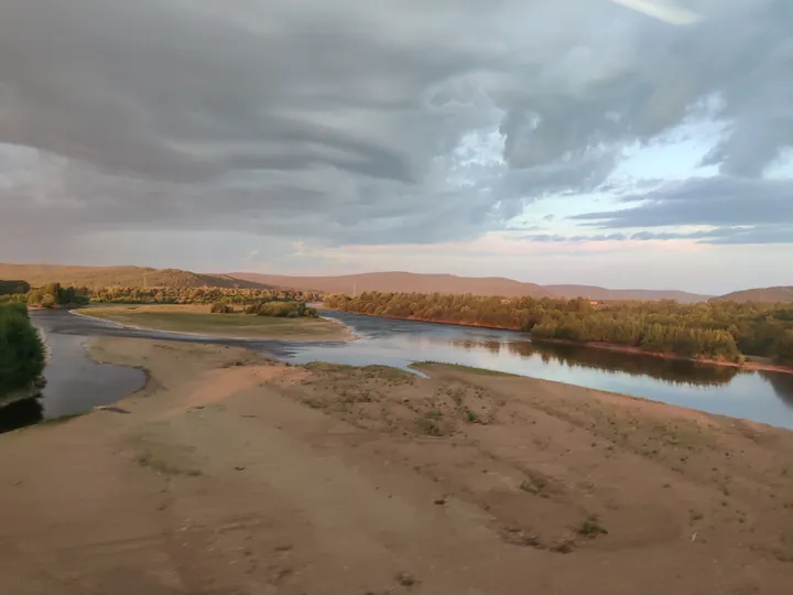
Photo adjustments
Full frame retained; proportionally resized and converted to WebP. No retouching or changes to the photographed subject. Card displays may crop the view.
- Administrative area
- County · 县
- Part of
- Daxing'anling Prefecture
- Chinese name
- 塔河县
- Local areas
- County guide
Area & population
- Area in the source
- 14,103.00 km²
Source: cited geographic source, as of the dates shown.
Setting and landscape
The Heilongjiang provincial culture and tourism department puts the county's forest cover at 90.7 per cent. The Huma River (呼玛河), which China National Radio describes as a national strategic water-reserve river, flows through the county town, Tahe town (塔河镇). Dicuiyuan Park (滴翠园公园) is part of the Guqigu National Wetland Park (固奇谷国家湿地公园). Winters are hard: Chinese Wikipedia's 1972–2007 figures give a January average high of −17.4°C and an average low of −31.5°C, while July highs average 25.6°C.
History and people
Tahe is one of the counties crossed by the Qing post road from Mergen to Mohe (墨尔根至漠河古驿站驿道), which is on the national list of major protected historical sites. The provincial culture and tourism department describes Shibazhan (十八站), an Oroqen (鄂伦春) ethnic township in the county, as the largest Oroqen township in China. It points to horseback archery, dress, food, embroidery and birch-bark handicrafts as the ways the old stories of the Oroqen are told.
What to see
The provincial department's list of places to visit includes the Qixia Mountain scenic area (栖霞山景区), a Quaternary glacial valley scenic area (第四纪冰川河谷景区), the Twenty-Second Station gold-route post (二十二站黄金古驿), Heilong Bay (黑龙湾), Longzhan Island (龙站岛), the Shibazhan Oroqen customs park (十八站鄂伦春风情园) and Guqigu wetland.
Food and local products
The same department lists the forest's produce: hongdou berries (红豆), blueberries (蓝莓), pork from forest-raised pigs, cold-water fish and wild mushrooms.
Highlights
- Shibazhan Oroqen Ethnic Township 十八站鄂伦春族乡: Described by the Heilongjiang culture and tourism department as the largest Oroqen ethnic township in China.
- Guqigu National Wetland Park 固奇谷国家湿地公园: National wetland park that includes Dicuiyuan Park.
- Mergen–Mohe post road 墨尔根至漠河古驿站驿道: Qing post road through Tahe, on the national list of protected sites.
Sources for this guide
塔河县 - 维基百科,自由的百科全书 · Chinese Wikipedia · CC BY-SA 4.0
黑龙江省境内的全国重点文物保护单位列表 - 维基百科,自由的百科全书 · Chinese Wikipedia · CC BY-SA 4.0
荣登2024中国最美县域榜单!探秘大兴安岭塔河-黑龙江省文化和旅游厅 · Heilongjiang Provincial Department of Culture and Tourism
【一百秒·一座城】绿美天地 心驰塔河_央广网 · China National Radio (CNR)
Original English written from the listed sources and checked sentence by sentence against quoted extracts by a separate reviewer. Updated 2026-09-24.
Explore Tahe County
Core places to explore, with English and Chinese names.
Places to explore around Tahe County
 Shibazhan Oroqen Ethnic Township ·
 Plan your visit
Getting there
Tahe County is about 60 km in a straight line from central Daxing'anling Prefecture. Search for 塔河县 in a map app to find stations and your accommodation.
Where to stay →Build your route
Start with Shibazhan Oroqen Ethnic Township. The linked place guides have entrance and visit details.
Continue with Daxing'anling Prefecture →More in Daxing'anling Prefecture
Sources & geographic information
Administrative names and parent areas: Official geographic directory · Reference date 2026-09-06.
Some facts checked against 塔河县 — Wikipedia contributors, CC BY-SA 4.0.
Some facts checked against 黑龙江省境内的全国重点文物保护单位列表 — Wikipedia contributors, CC BY-SA 4.0.
Photo: Shibazhan Oroqen Ethnic Township · Source photographer · License not provided. EXIF orientation normalized; resized without changing aspect ratio; converted to WebP. No subject edits.
Map data © OpenStreetMap contributors. Pins mark approximate centres, not entrances or boundaries.