


Get to know Bei'an
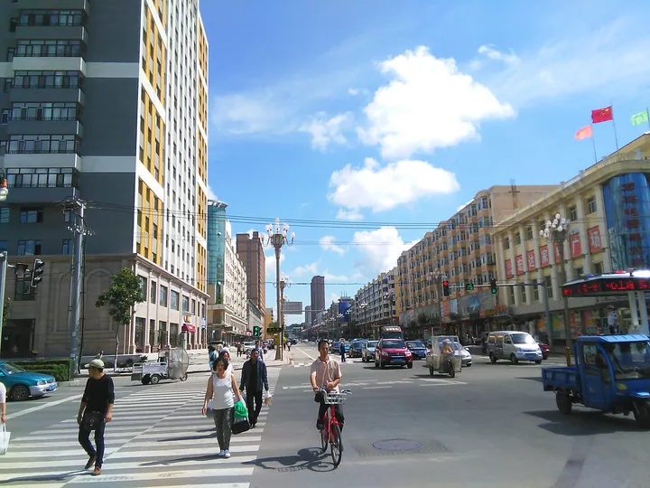
Photo adjustments
Full frame retained; proportionally resized and converted to WebP. No retouching or changes to the photographed subject. Card displays may crop the view.
- Administrative area
- County-level city · 县级市
- Part of
- Heihe
- Chinese name
- 北安市
- Local areas
- County-level city guide
Area & population
- Area in the source
- 6,313.00 km²
- Population · 2010
- 436,444
- Administrative seat
- Heping Subdistrict (和平街道)
Source: cited geographic source, as of the dates shown.
Setting and landscape
The city borders Xunke (逊克县) and Suiling (绥棱县) counties to the east, Baiquan (拜泉县) and Kedong (克东县) to the west and Wudalianchi (五大连池市) to the north. In the south the Tongken River (通肯河) forms the line with Hailun (海伦市). The city government places Bei'an in the transition zone between the black-soil Songnen Plain and the Xing'an uplands, farmland given over to soybeans, maize, rice and potatoes.
History
The Jin dynasty kept a garrison unit here, the Hesukunshan mouke (曷苏昆山谋克), before its people moved south. Japanese troops occupied Longzhen County (龙镇县) in 1932; under Manchukuo its seat moved to Bei'an town, and the county was renamed Bei'an in 1939. After Japan's defeat in 1945 the Communist Party set up Heilongjiang province with its party committee and government based in Bei'an, until the 1949 merger with Nenjiang province moved the capital to Qiqihar (齐齐哈尔).
The city government credits Bei'an with a string of firsts: the Northeast Military and Political University (东北军政大学) and other cadre schools, New China's first submachine-gun factory, its first state-run mechanised farm, and Liang Jun (梁军), trained here in 1948 as the country's first woman tractor driver. A Shenyang gun works moved to Bei'an in 1950 during the Korean War. The present city dates from 1983, after an earlier city of 1960 was dissolved in 1963.
What to see
The former site of the Heilongjiang provincial party committee and government (黑龙江省委省政府旧址) is one of 18 halls that the city government describes as China's only county-level cluster of revolutionary museums, promoted under the slogan "from Yan'an to Bei'an" (从延安到北安). The submachine-gun works was later renamed the Qinghua Tool Factory (庆华工具厂), and the city also has a Qinghua military-industry site museum (庆华军工遗址博物馆).
Food and local products
Bei'an is a main growing area for non-GM soybeans. Its organic sauerkraut stewed with goose (有机酸菜炖大鹅) appeared in the fourth season of the documentary "A Bite of China" (舌尖上的中国), and Hongxing sauerkraut (红星酸菜) from the Hongxing Farm (红星农场) is a national geographical-indication product.
Getting oriented
Bei'an sits between the prefecture-level cities of Heihe, Suihua (绥化), Qiqihar and Yichun (伊春), on the overland route from inland China through Heihe to Russia. The Binbei line from Harbin (哈尔滨) and the Qibei line from Qiqihar meet at Bei'an station, where the Beihei line to Heihe begins, and national highways G202 and G332 cross the city.
Highlights
- Former site of the Heilongjiang provincial party committee and government 黑龙江省委省政府旧址: One of the 18 halls in what the city government calls China's only county-level revolutionary museum group.
- Qinghua military-industry site museum 庆华军工遗址博物馆: Shares its name with the Qinghua Tool Factory, the later name of the gun works moved from Shenyang in 1950.
- Hongxing sauerkraut 红星酸菜: National geographical-indication product from the Hongxing Farm.
Sources for this guide
北安市情简介_市情概况_北安市人民政府 · Bei'an City People's Government
地理特征_自然地理_北安市人民政府 · Bei'an City People's Government
北安市 - 维基百科,自由的百科全书 · Wikipedia (Chinese) · CC BY-SA 4.0
Original English written from the listed sources and checked sentence by sentence against quoted extracts by a separate reviewer. Updated 2026-09-30.
Explore Bei'an
Core places to explore, with English and Chinese names.
Plan your visit
Getting there
Bei'an is about 235 km in a straight line from central Heihe. Search for 北安市 in a map app to find stations and your accommodation.
Where to stay →More in Heihe
Sources & geographic information
Administrative names and parent areas: Official geographic directory · Reference date 2026-09-06.
Some facts checked against 北安市 — Wikipedia contributors, CC BY-SA 4.0.
Map data © OpenStreetMap contributors. Pins mark approximate centres, not entrances or boundaries.