


Get to know Tongbai County

Photo adjustments
Full frame retained; proportionally resized and converted to WebP. No retouching or changes to the photographed subject. Card displays may crop the view.
- Administrative area
- County · 县
- Part of
- Nanyang
- Chinese name
- 桐柏县
- Local areas
- County guide
Area & population
- Area in the source
- 1,941.00 km²
- Population · 2019
- 404,900
Source: cited geographic source, as of the dates shown.
Setting and landscape
The Huai, one of the four great rivers (四渎) of ancient China, is treated as the line between China's north and south in both geography and climate. Its source is the Great Huai Well (大淮井) on Taibai Peak (太白顶), at 1,140 metres the highest peak of the Tongbai Mountains, while a cliff on the west side of the same peak feeds the Li River (澧水), a tributary of the Yangtze. Forest covers 57 percent of the county.
History
The Western Han set up Fuyang County (复阳县) here, and the name Tongbai dates from 598 under the Sui. The Huai Shrine (淮祠) at the river's source was founded under the Qin; the county describes it as China's earliest official body for managing the Huai. More than fifty emperors sent envoys to make offerings to the river, and the Kangxi Emperor wrote the inscription "灵渎安澜" ("the sacred river flows calm"). The shrine now houses the China Huaiyuan Folk Museum (中国淮河源民俗博物馆).
Tongbai is also tied to Pangu (盘古), the creator figure of Chinese myth: the Pangu myth and the Pangu temple fair are on the national intangible-heritage list, and in 2005 the China Folk Literature and Art Association named Tongbai the home of Pangu. In the 20th century the county was a revolutionary base; the Tongbai Revolutionary Memorial Hall (桐柏革命纪念馆) on the south side of the county town carries a name board written by Li Xiannian (李先念).
What to see
The Tongbaishan Huaiyuan Scenic Area (桐柏山淮源风景名胜区) covers 108 square kilometres and became a national forest park in 2003, a national scenic area in 2009 and a national 4A tourist area in 2016. It has four parts: the Huai source, Taohua Cave (桃花洞), Taibai Peak and Shuilian Cave (水帘洞). On the summit, Yuntai Chan Temple (云台禅寺) straddles the Henan–Hubei border and is the ancestral temple of the Baiyun branch of the Linji school of Chan Buddhism. Shuilian Temple (水帘寺), below Shuilian Cave, is counted among the four famous temples of the Central Plains. Above 800 metres on Xiaopingding (小平顶), wild azaleas cover about ten thousand mu (some 670 hectares), including more than 30,000 plants a century old.
Food and local products
Tongbai marks the northern limit of tea grown in the north from southern stock and has more than 2,000 years of tea growing. Its two county brands are Tongbai Yuye (桐柏玉叶) and Tongbai Hong (桐柏红). The county is also known for Chinese quince (木瓜) and chestnuts, and its Tongbai balloon-flower root (桐桔梗) and Zhushahong peach (朱砂红桃) carry national geographical-indication status.
Highlights
- Taibai Peak 太白顶: 1,140 m highest peak of the Tongbai Mountains, where the Great Huai Well marks the source of the Huai.
- Huai Shrine 淮祠: Qin-era shrine at the Huai source, now home to the China Huaiyuan Folk Museum.
- Yuntai Chan Temple 云台禅寺: Summit temple on the Henan-Hubei border, ancestral temple of the Baiyun branch of Linji Chan.
- Tongbai Revolutionary Memorial Hall 桐柏革命纪念馆: Memorial on the south side of the county town with a name board written by Li Xiannian.
- Tongbai Yuye tea 桐柏玉叶: One of the county's two tea brands, from the northern limit of tea growing.
Sources for this guide
桐柏概况-桐柏概况-桐柏县人民政府 · Tongbai County People's Government (county gazetteer office)
桐柏山淮源景区简介-桐柏旅游-桐柏县人民政府 · Tongbai County People's Government
桐柏文旅资源概况-桐柏旅游-桐柏县人民政府 · Tongbai County People's Government
Original English written from the listed sources and checked sentence by sentence against quoted extracts by a separate reviewer. Updated 2026-09-24.
Explore Tongbai County
Core places to explore, with English and Chinese names.
Places to explore around Tongbai County
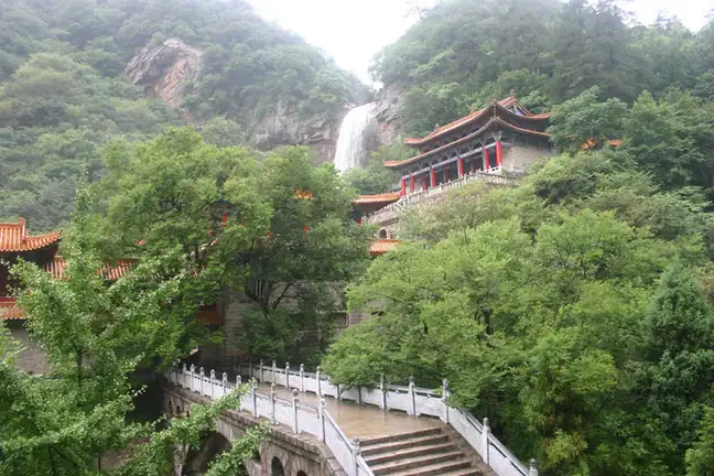 Tongbai Mountain Huai River Source ·
 Plan your visit
Getting there
Tongbai County is about 105 km in a straight line from central Nanyang. Search for 桐柏县 in a map app to find stations and your accommodation.
Where to stay →Build your route
Start with Tongbai Mountain Huai River Source. The linked place guides have entrance and visit details.
Continue with Nanyang →More in Nanyang
Sources & geographic information
Administrative names and parent areas: Official geographic directory · Reference date 2026-09-06.
Photo: Tongbai Mountain Huai River Source · Source photographer · License not provided. EXIF orientation normalized; resized without changing aspect ratio; converted to WebP. No subject edits.
Map data © OpenStreetMap contributors. Pins mark approximate centres, not entrances or boundaries.