


Get to know Xichuan County
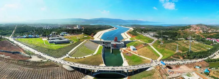
Photo adjustments
Full frame retained; proportionally resized and converted to WebP. No retouching or changes to the photographed subject. Card displays may crop the view.
- Administrative area
- County · 县
- Part of
- Nanyang
- Chinese name
- 淅川县
- Local areas
- County guide
Area & population
- Area in the source
- 2,817.00 km²
- Population · 2019
- 626,100
Source: cited geographic source, as of the dates shown.
Setting and landscape
Mountains close the county in on the north, west and south, giving a horseshoe-shaped terrain that rises in the north-west and tilts to the south-east, between 120 and 1,086 metres above sea level. The Dan River (丹江), a direct tributary of the Han (汉江), crosses the whole county from north-west to south-east, fed by the Laoguan (老鹳河), Qi (淇河) and Tao (滔河) rivers. At its normal level of 170 metres the reservoir covers 506.18 square kilometres; the county government calls it Asia's largest man-made freshwater lake.
History
The county government places Danyang (丹阳), the first capital of the state of Chu (楚), within Xichuan, now under the reservoir. In 312 BC the Chu army was routed by Qin along the Dan and Xi (淅水) rivers inside today's county, after which the whole area passed to Qin. After Liu Tong (刘通) led tens of thousands of displaced migrants in revolt here in 1465, the Ming court split Xichuan off from Neixiang (内乡) as its own county in 1470.
Filling the reservoir in August 1960 drowned 548,400 mu of land, including the Shunyang (顺阳川), Danyang (丹阳川) and Banqiao (板桥川) plains, the county's richest farmland, and the seat moved to Shangji (上集), 40 kilometres from the old town. In 1972 Taocha village (陶岔村), where the middle-route canal begins, passed to Xichuan from Deng County (邓县).
What to see
Jingziguan (荆紫关), 75 kilometres from the county seat at the three-province junction, keeps a Qing street about five li long whose more than 700 Qing buildings largely keep their original form; it became a national key cultural relic in 2001. Along it stand the Pinglang Palace (平浪宫), paid for by boat households on the old Dan River route, and the Shanxi-Shaanxi Guild Hall (山陕会馆), built by merchants in 1833. At Bailang Street (白浪街), shared by the three provinces, a friendship stele pavilion was built jointly by their people in 1987; a three-sided stone below it lets one step land in all three.
Xiangyan Temple (香严寺), in the Baiya Mountains (白崖山) of Cangfang town (仓房镇), was founded in the Tang dynasty. Its lower monastery was lost to the reservoir; the surviving upper temple, a national key cultural relic since 2006, has more than 140 rooms, mostly Ming and Qing buildings. Danjiang Daguanyuan (丹江大观苑), a national 4A scenic area of small islands on the reservoir's north shore, includes a memorial hall to the water transfer project.
Highlights
- Jingziguan 荆紫关: Qing street of more than 700 buildings at the Henan-Hubei-Shaanxi junction; national key cultural relic since 2001.
- Xiangyan Temple 香严寺: Tang-founded temple in the Baiya Mountains; its upper monastery survives, a national key cultural relic since 2006.
- Danjiang Daguanyuan 丹江大观苑: National 4A scenic area of islands on the north shore of the Danjiangkou Reservoir.
- Danjiangkou Reservoir 丹江口水库: Core water source of the middle route of the South-North Water Transfer Project.
Sources for this guide
历史沿革_历史沿革_淅川县人民政府 · Xichuan County People's Government
自然资源_自然资源_淅川县人民政府 · Xichuan County People's Government
风景名胜_淅川县人民政府 (荆紫关) · Xichuan County People's Government
风景名胜_淅川县人民政府 (丹江大观苑) · Xichuan County People's Government
风景名胜_淅川县人民政府 (香严寺) · Xichuan County People's Government
Original English written from the listed sources and checked sentence by sentence against quoted extracts by a separate reviewer. Updated 2026-09-24.
Explore Xichuan County
Core places to explore, with English and Chinese names.
Places to explore around Xichuan County
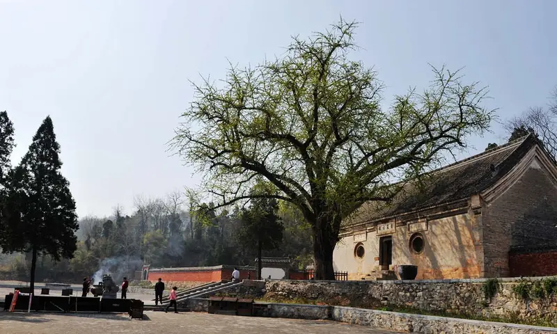 Xiangyan Temple (香严寺), Xichuan County. Photograph: "Hnxcxys (3)".
Xiangyan Temple香严寺
Xiangyan Temple (香严寺) stands on Baiya Shan in Cangfang Town, Xichuan County, Nanyang, Henan, a Tang foundation whose surviving Ming and Qing halls keep a large set of Ming wall paintings.
Read the place guide → AI illustration · AI 示意图(仅供参考,非该地点实拍)
Danjiang Grand View Garden丹江大观苑
Island park on the Danjiangkou Reservoir in Xichuan County with a rebuilt temple, a large Guanyin statue and a herb plantation.
Read the place guide →Plan your visit
Getting there
Xichuan County is about 100 km in a straight line from central Nanyang. Search for 淅川县 in a map app to find stations and your accommodation.
Where to stay →Build your route
Xiangyan Temple and Danjiang Grand View Garden are both listed here. The linked place guides have entrance and visit details.
Continue with Nanyang →More in Nanyang
Sources & geographic information
Administrative names and parent areas: Official geographic directory · Reference date 2026-09-06.
Photo: Xiangyan Temple · 襄樊一夜 · CC BY-SA 3.0. Full frame retained; EXIF orientation normalized, proportionally resized to at most 800 pixels and converted to WebP. No generated pixels or subject changes. Cards may crop the display.

Map data © OpenStreetMap contributors. Pins mark approximate centres, not entrances or boundaries.