


Get to know Tsuen Wan District
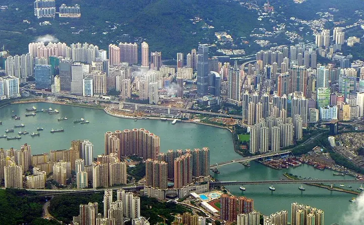
Photo adjustments
Full frame retained; proportionally resized and converted to WebP. No retouching or changes to the photographed subject. Card displays may crop the view.
- Administrative area
- District · 地區
- Part of
- Hong Kong
- Chinese name
- 荃灣
- Local areas
- District guide
Area & population
- Area in the source
- 60.70 km²
- Population · 2016
- 318,916
Source: cited geographic source, as of the dates shown.
Setting and landscape
Behind the town, Shing Mun Reservoir (城門水塘) fills a valley that once held ten villages growing mainly pineapples; its dam is called Po Lo Pa (菠蘿壩), literally "pineapple dam", and the valley also has a disused lead mine where some Tsuen Wan residents once worked. Tai Mo Shan (大帽山) rises beyond. The Tsuen Wan District Council lists Tai Mo Shan Country Park and Shing Mun Country Park among the district's favourite scenic spots, together with the Yuen Tsuen Ancient Trail (元荃古道), and notes the beaches around Ting Kau (汀九).
What to see
Sam Tung Uk Museum (三棟屋博物館) is a cultural and agricultural museum set up in a former Hakka walled village, and The Mills (南豐紗廠) is another historic building the district council describes as preserved. Around Lo Wai (老圍), the Yuen Yuen Institute (圓玄學院), the Western Monastery (西方寺) and Chuk Lam Sim Yuen (竹林禪院) form a cluster of temples. Hong Kong Disneyland lies inside the district boundary on Lantau, partly extending into Islands District. The town centre is known for its extensive footbridge network.
Food
The district council singles out three places to eat: restaurants at Sham Tseng (深井), countryside teahouses at Chuen Lung (川龍), and local diners in the town centre.
Getting oriented
Tsuen Wan links the western New Territories and Lantau with the urban area and is described by the district council as the gateway to the airport. Tsuen Wan station is the terminus of the MTR Tsuen Wan line, the Tuen Ma line stops at Tsuen Wan West on the waterfront, and the Disneyland Resort line runs within the district's Lantau section through Sunny Bay. The district was created in 1982 and originally included Kwai Chung and Tsing Yi, which were split off in the mid-1980s to form Kwai Tsing District.
Highlights
- Sam Tung Uk Museum 三栋屋博物馆: Cultural and agricultural museum in a former Hakka walled village.
- Tai Mo Shan 大帽山: The hill behind the Shing Mun valley; Tai Mo Shan Country Park is one of the district's favourite scenic spots.
- Hong Kong Disneyland 香港迪士尼乐园: Within the Tsuen Wan District boundary on Lantau, partly in Islands District.
- Yuen Yuen Institute 圆玄学院: Part of the temple cluster around Lo Wai with the Western Monastery and Chuk Lam Sim Yuen.
Sources for this guide
Tsuen Wan District Council - District Highlights · Tsuen Wan District Council, Hong Kong SAR Government
Tsuen Wan District · Wikipedia · CC BY-SA 4.0
Original English written from the listed sources and checked sentence by sentence against quoted extracts by a separate reviewer. Updated 2026-09-25.
Explore Tsuen Wan District
Core places to explore, with English and Chinese names.
Places to explore around Tsuen Wan District
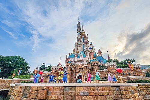 Hong Kong Disneyland · 香港迪士尼乐园
Hong Kong Disneyland香港迪士尼乐园
Hong Kong Disneyland combines elaborate ride settings with the Castle of Magical Dreams, whose design draws on thirteen Disney princess and queen stories. Frozen Ever After takes passengers by boat through Arendelle-inspired…
Read the place guide →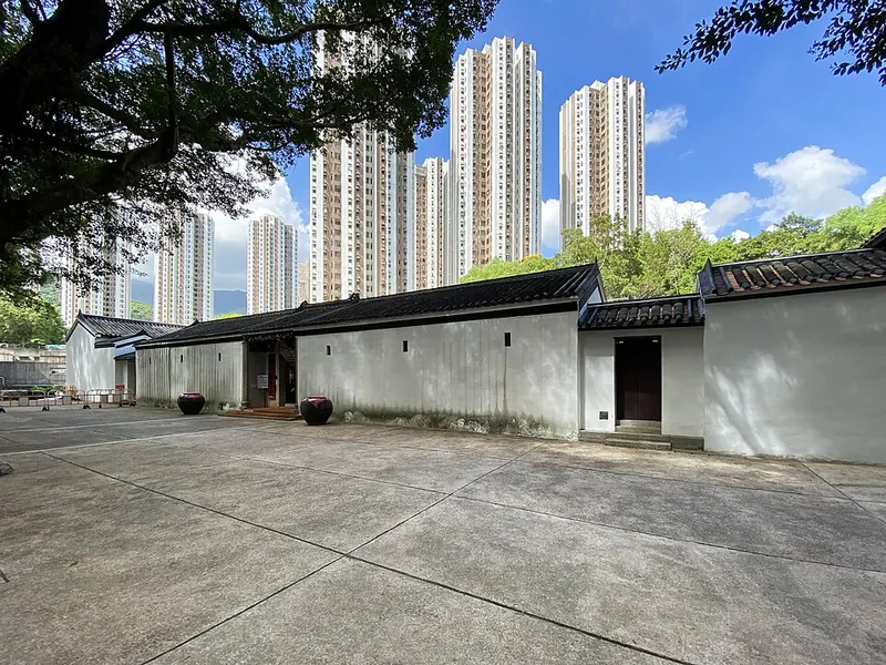 Courtyard at Sam Tung Uk Museum. Photograph date recorded by the source: 2020-07.
Sam Tung Uk Museum三栋屋博物馆
Sam Tung Uk Museum preserves the layout of a Hakka walled village within present-day Tsuen Wan. The entrance, assembly and ancestral halls form the communal core, with original houses arranged around them. Moving through this…
Read the place guide → Tai Mo Shan summit viewed from Tai Mo Shan Road · 从大帽山道远望大帽山山顶 Capture date not established by the retained file page.
Tai Mo Shan大帽山
Tai Mo Shan offers a progression from the garden spaces of Rotary Park to exposed upland views. The lower park has a sundial, Chinese-style pavilion and woodland viewpoint; farther uphill, the country-park visitor centre…
Read the place guide →Plan your visit
Getting there
Tsuen Wan District is about 6 km in a straight line from central Hong Kong. Search for 荃灣 in a map app to find stations and your accommodation.
Where to stay →Build your route
Hong Kong Disneyland and Sam Tung Uk Museum are about 10 km apart in a straight line. The linked place guides have entrance and visit details.
Continue with Hong Kong →More in Hong Kong
Sources & geographic information
Administrative names and parent areas: Official geographic directory · Reference date 2026-09-06.
Some facts checked against Tsuen Wan District — Wikipedia contributors, CC BY-SA 4.0.
Photo: Hong Kong Disneyland · Ashwin Kumar · CC BY-SA 2.0. Wikimedia thumbnail; fitted to the ranking-card frame.

Photo: Sam Tung Uk Museum · Wpcpey · CC BY 4.0. Full frame retained; proportionally resized and converted to WebP. No retouching or changes to the photographed subject. Card displays may crop the view.

Photo: Tai Mo Shan · C J B Scholten at English Wikipedia · C J B Scholten at English Wikipedia — R38943400718_Tai_Mo_Shan_Road_(大帽山道),_and_Tai_Mo_Shan_peak_in_distance.JPG — CC BY 2.5 · CC BY 2.5. The exact downloaded source bytes are separately retained and hashed. Prepared JPEG is proportionally reduced to a maximum 720-pixel long edge; full frame retained, no subject alteration. Final website rendition: full frame retained, proportionally resized to at most 720 pixels and converted to WebP. No additional retouching or subject alteration. Card displays may crop the view.
,_and_Tai_Mo_Shan_peak_in_distance.JPG)
Map data © OpenStreetMap contributors. Pins mark approximate centres, not entrances or boundaries.