


Get to know Xianfeng County

- Administrative area
- County · 县
- Part of
- Enshi Tujia and Miao Autonomous Prefecture
- Chinese name
- 咸丰县
- Local areas
- County guide
Area & population
- Area in the source
- 2,550.00 km²
- Population · 2020
- 318,827
Source: cited geographic source, as of the dates shown.
Setting and landscape
The county is high in the south and low in the middle, tilting from northeast to southwest. The Xianfeng county government counts 574 larger caves, Huangjin Cave (黄金洞) among the best known. The highest point, 1,911.5 metres, is at Shihuiyao (石灰窑) on Pingbaying (坪坝营), a limestone massif on the border with Qianjiang 35 kilometres from the county town; the lowest, 435 metres, is at Yuquankou (渔泉口). The county town, Gaoleshan (高乐山镇), stands at 720 metres, 93 kilometres by road from the prefecture seat at Enshi.
History
From 1293, under the Yuan, the area was divided among hereditary chiefs, set up one after another, among them Sanmao (散毛), Jindong (金峒), Longtan (龙潭) and Tangya (唐崖). In 1390 the Ming carved half of Sanmao's land out as the Datian garrison (大田军民千户所), based at Dashuitian (大水田), today's Gaoleshan. In 1735 the Qing abolished the chiefdoms and joined them with Datian into a new county named from the phrase "咸庆丰年" ("all celebrate a bountiful year").
What to see
The Tangya Tusi city site (唐崖土司城址), in Tangyasi village of Tangya town (唐崖镇), was built in 1355 and abandoned in 1735; the county bureau describes it as once the political, military, economic and cultural centre of the surrounding region. It covers 74 hectares, became a national key protected site in 2006 and, on 4 July 2015, was inscribed as a component of China's Tusi Sites on the World Heritage List, the first in Enshi. Its street plan of "three streets and eighteen lanes" has a main street of blue sandstone slabs nearly 880 metres long, which the county bureau calls the country's best-preserved Ming stone road. There are 36 courtyards and the east-facing yamen (衙署) terraced up the slope. On Xuanwu Hill (玄武山) stand two intertwined firs over 400 years old, said to have been planted by the chief Qin Ding (覃鼎) and his wife.
Pingbaying, where Hubei meets Chongqing, is a forest area with 96 percent tree cover that the county bureau describes as holding Hubei's largest primeval forest community. Its Sidong Gorge (四洞峡) has a rare cluster of sinkholes and through-caves.
Highlights
- Tangya Tusi city site 唐崖土司城址: Chiefs' town built in 1355 and abandoned in 1735; World Heritage since 2015 as part of the Tusi Sites.
- Pingbaying 坪坝营: Limestone forest massif on the Chongqing border, with the county's highest point and the sinkholes of Sidong Gorge.
- Huangjin Cave 黄金洞: One of the best-known of the county's 574 larger caves.
Sources for this guide
咸丰概况 · Xianfeng County People's Government (county statistics bureau)
历史沿革 · Xianfeng County People's Government
咸丰县 - 维基百科 · Wikipedia (Chinese) · CC BY-SA 4.0
唐崖土司城址 · Enshi Prefecture People's Government (Xianfeng County Culture and Tourism Bureau)
咸丰坪坝营 · Enshi Prefecture People's Government (Xianfeng County Culture and Tourism Bureau)
Original English written from the listed sources and checked sentence by sentence against quoted extracts by a separate reviewer. Updated 2026-09-24.
Explore Xianfeng County
Core places to explore, with English and Chinese names.
Places to explore around Xianfeng County
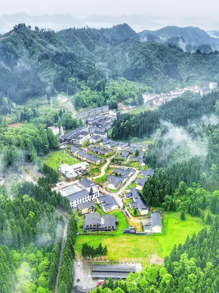 Pingbaying Scenic Area ·
 Plan your visit
Getting there
Xianfeng County is about 75 km in a straight line from central Enshi Tujia and Miao Autonomous Prefecture. Search for 咸丰县 in a map app to find stations and your accommodation.
Where to stay →Build your route
Start with Pingbaying Scenic Area. The linked place guides have entrance and visit details.
Continue with Enshi Tujia and Miao Autonomous Prefecture →More in Enshi Tujia and Miao Autonomous Prefecture
Sources & geographic information
Administrative names and parent areas: Official geographic directory · Reference date 2026-09-06.
Some facts checked against 咸丰县 — Wikipedia contributors, CC BY-SA 4.0.
Photo: Pingbaying Scenic Area · Source photographer · License not provided. EXIF orientation normalized; resized without changing aspect ratio; converted to WebP. No subject edits.
Map data © OpenStreetMap contributors. Pins mark approximate centres, not entrances or boundaries.