


Get to know Enshi

Photo adjustments
The exact downloaded source bytes are separately retained and hashed. Prepared JPEG is proportionally reduced to a maximum 720-pixel long edge; full frame retained, no subject alteration. Final website rendition: full frame retained, proportionally resized to at most 720 pixels and converted to WebP. No additional retouching or subject alteration. Card displays may crop the view.
- Administrative area
- County-level city · 县级市
- Part of
- Enshi Tujia and Miao Autonomous Prefecture
- Chinese name
- 恩施市
- Local areas
- County-level city guide
Area & population
- Area in the source
- 3,971.58 km²
- Population · 2020 census
- 836,781
- Administrative seat
- Xiaoduchuan Subdistrict
Source: cited geographic source, as of the dates shown.
History
Under the Three Kingdoms state of Wu and the Jin the area was Shaqu County (沙渠县). It became Shizhou (施州) under the Tang and was a garrison, Shizhou Wei (施州卫), under the Ming. Enshi County was created in 1728, and during the war against Japan the town served as the temporary capital of Hubei. Enshi City was formed from the county town in 1981 and absorbed the rest of the county in 1983. Tujia, Miao and Dong people make up most of the minority population.
What to see
Enshi Grand Canyon (恩施大峡谷) lies at Mufu (沐抚), about 60 kilometres from the city centre. It is a world geopark and a national 5A scenic area, and the prefecture government describes its combination of fissure gorge, sinkholes and rock pillars as unique in the world. Old salt and official roads into Sichuan once ran through it. The Yunlong River fissure (云龙河地缝) runs for 7.5 kilometres and reaches 75 metres deep, with waterfalls pouring down its walls.
Enshi Tusi City (恩施土司城), 1.5 kilometres from the centre, is a replica estate of the Tujia hereditary chieftains, named by the sociologist Fei Xiaotong (费孝通) and opened in 2002; its centrepiece, the Nine-Courtyard Hall (九进堂), gathers stilt houses, a hand-waving dance hall and an opera stage. Enshi Nü'er City (恩施女儿城), a 4A area since 2014, is built around the Nü'er Hui (女儿会), a Tujia festival that is held there. In the northwest of the city, where it meets Jianshi (建始) and Fengjie, the Suobuya Stone Forest (梭布垭石林) is a 4A area of rock formed in the Ordovician about 460 million years ago, known for its "dissolution-pattern" and "capped" stones.
Food and local products
Enshi holds large deposits of selenium and is known in China as the "selenium capital" (硒都). Four local products are national geographical-indication products: Enshi Yulu (恩施玉露), Enshi purple-oil magnolia bark (紫油厚朴), Enshi yellow-cattle beef and Enshi black pork.
Getting oriented
Jianshi County lies to the east and Lichuan (利川) to the west. The Yichang–Wanzhou railway (宜万铁路) crosses the city, and Enshi Station is modelled on the Tujia stilt house (吊脚楼). The Shanghai–Chongqing Expressway and Xujiaping Airport (许家坪机场) also serve the city.
Highlights
- Enshi Grand Canyon 恩施大峡谷: World geopark and national 5A scenic area at Mufu, with the 7.5-kilometre Yunlong River fissure.
- Enshi Tusi City 恩施土司城: Replica Tujia chieftain estate named by Fei Xiaotong, opened in 2002.
- Enshi Nü'er City 恩施女儿城: 4A area since 2014, where the Tujia Nü'er Hui festival is held.
- Suobuya Stone Forest 梭布垭石林: Ordovician stone forest in the northwest of the city, about 460 million years old.
- Enshi Yulu 恩施玉露: A national geographical-indication product.
Sources for this guide
恩施市 - 维基百科,自由的百科全书 · Wikipedia (Chinese) · CC BY-SA 4.0
恩施大峡谷 - 恩施州人民政府门户网站 · Enshi Tujia and Miao Autonomous Prefecture People's Government
恩施土司城 - 恩施州人民政府门户网站 · Enshi Tujia and Miao Autonomous Prefecture People's Government
恩施女儿城 - 恩施州人民政府门户网站 · Enshi Tujia and Miao Autonomous Prefecture People's Government
恩施梭布垭石林 - 恩施州人民政府门户网站 · Enshi Tujia and Miao Autonomous Prefecture People's Government
Original English written from the listed sources and checked sentence by sentence against quoted extracts by a separate reviewer. Updated 2026-09-25.
Explore Enshi
Core places to explore, with English and Chinese names.
Places to explore around Enshi
Rock pinnacles and mist in Enshi Grand Canyon · 恩施大峡谷石峰与云雾 Photograph date recorded by the source: Taken on 5 July 2010.Enshi Grand Canyon恩施大峡谷
Enshi Grand Canyon combines two contrasting karst experiences. Qixingzhai follows high cliffs and isolated rock pillars, while Yunlong Ground Fissure descends into a narrow water-cut chasm. The famous Incense Stick pillar…
Read the place guide →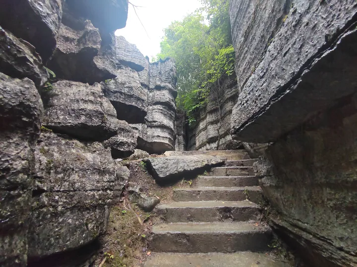 A stone stairway through the karst rock formations of Suobuya Stone Forest, Enshi · 恩施梭布垭石林中的石阶步道 Source-recorded photograph date: 2024-07-26 15:17:59.
Suobuya Stone Forest梭布垭石林
A 21 km² karst stone forest with marine fossils in northwest Enshi City, Hubei; its name, from the Tujia word for three, means 'three passes'.
Read the place guide →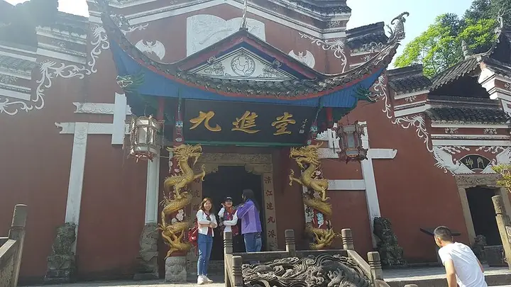 Jiujintang entrance at Enshi Tusi City · 恩施土司城九进堂入口 Photograph date recorded by the source: 29 April 2017, 10:08:29.
Enshi Tusi Imperial City恩施土司城
Enshi Tusi City is a modern cultural complex inspired by the architecture and history of regional hereditary rulers. Its gateway, Linjun shrine and Jiujintang palace sequence bring different building forms into one visitor…
Read the place guide → Enshi Girls' City (恩施女儿城), Enshi. Photograph: "恩施 土家女儿城 01".
Enshi Girls' City恩施女儿城
Enshi Tujia Nver Cheng (恩施女儿城) is a purpose-built Tujia-themed street district in Enshi City, the seat of the Enshi Tujia and Miao Autonomous Prefecture in western Hubei. It was created around the culture of the Enshi Nverhui, a Tujia courtship festival, and was assessed as a national AAAA tourist area in 2014.
Read the place guide →Plan your visit
Getting there
Enshi covers the centre of Enshi Tujia and Miao Autonomous Prefecture. Search for 恩施市 in a map app to find stations and your accommodation.
Where to stay →Build your route
Enshi Grand Canyon and Suobuya Stone Forest are both listed here. The linked place guides have entrance and visit details.
Continue with Enshi Tujia and Miao Autonomous Prefecture →More in Enshi Tujia and Miao Autonomous Prefecture
Sources & geographic information
Administrative names and parent areas: Official geographic directory (dmfw.mca.gov.cn) · Reference date 2026-09-06.
Some facts checked against 恩施市 — Wikipedia contributors, CC BY-SA 4.0.
Photo: Enshi Grand Canyon · 图片上传者:吴显胜(China) · CC BY 3.0. The exact downloaded source bytes are separately retained and hashed. Prepared JPEG is proportionally reduced to a maximum 720-pixel long edge; full frame retained, no subject alteration. Final website rendition: full frame retained, proportionally resized to at most 720 pixels and converted to WebP. No additional retouching or subject alteration. Card displays may crop the view.

Photo: Suobuya Stone Forest · HoweyYuan · CC BY-SA 4.0. Full frame retained; proportionally resized and converted to WebP. No retouching or changes to the photographed subject. Card displays may crop the view.

Photo: Enshi Tusi Imperial City · Fxqf · Fxqf — 恩施土司城九进堂.jpg — CC BY-SA 4.0 · CC BY-SA 4.0. The exact downloaded source bytes are separately retained and hashed. Prepared JPEG is proportionally reduced to a maximum 720-pixel long edge; full frame retained, no subject alteration. Final website rendition: full frame retained, proportionally resized to at most 720 pixels and converted to WebP. No additional retouching or subject alteration. Card displays may crop the view.

Photo: Enshi Girls' City · Liuxingy · CC BY-SA 4.0. Full frame retained; EXIF orientation normalized, proportionally resized to at most 800 pixels and converted to WebP. No generated pixels or subject changes. Cards may crop the display.

Map data © OpenStreetMap contributors. Pins mark approximate centres, not entrances or boundaries.