


Get to know Lixian
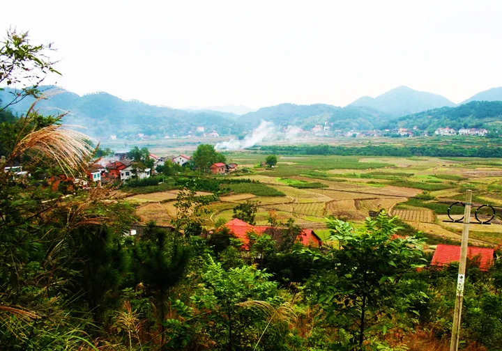
Photo adjustments
Full frame retained; proportionally resized and converted to WebP. No retouching or changes to the photographed subject. Card displays may crop the view.
- Administrative area
- County · 县
- Part of
- Changde
- Chinese name
- 澧县
- Local areas
- County guide
Area & population
- Area in the source
- 2,075.00 km²
Source: cited geographic source, as of the dates shown.
Setting and landscape
The land falls from northwest to southeast through four zones of mountains, hills, plains and lakes, and the county covers most of the Liyang Plain (澧阳平原). Its highest point is Yamujian (鸭母尖) on Mount Taiqing (太青山) at 1,019.5 metres. Five rivers cross it: the Li, the Cen (涔), the Dan (澹), the Dao (道) and the Songzi (松滋). The county government describes the climate as inland monsoon on the northern edge of the mid-subtropics, with four distinct seasons and plentiful rain.
History
The area was long known as Lizhou (澧州), a prefecture first set up in 555 under Emperor Jing of Liang (梁敬帝). In September 1913 the prefecture was abolished and the name Lixian came into use. The county government lists Fan Zhongyan (范仲淹) among those who studied here, and notes that He Long (贺龙) served as garrison commander of Lizhou and founded the Lizhou political training school with Zhou Yiqun (周逸群). Jiang Yiwu (蒋翊武), commander-in-chief of the Wuchang Uprising, came from the county.
What to see
The Chengtoushan site (城头山遗址), in Chengtoushan village, preserves a settlement from about 6,500 years ago. The county government calls it the earliest, richest in relics and best-preserved ancient city site found in China so far; it was twice chosen among the national top ten archaeological discoveries and was shown as "China's earliest city" in the China Pavilion at the Shanghai World Expo. In 2023 the Chengtoushan National Archaeological Site Park was placed on a national Yangtze-themed tourism route.
The Jijiaocheng site (鸡叫城遗址) is among Hunan's first provincial-level major sites. Together with Chengtoushan, Pengtoushan (彭头山) and Bashidang (八十垱), it forms the Liyang Plain prehistoric site group, which is being put forward for World Heritage nomination.
Food and local products
Farming here centres on rice, cotton and rapeseed, with grapes and citrus as specialities. The county is known as a "land of fish and rice" and as the "Turpan of the South" (南方吐鲁番).
Getting oriented
Lixian borders Songzi (松滋市) and Gong'an (公安县) in Hubei to the north, Linli County (临澧县) to the south, Anxiang (安乡县) and Jinshi (津市市) to the east, and Shimen County (石门县) to the west. Lixian station, in Jinluo town (金罗镇), is the first stop of the Jiaozuo-Liuzhou railway (焦柳铁路) after it enters Hunan from Hubei, and the Erenhot-Guangzhou Expressway (二广高速) passes through. The county government puts the Yangtze shipping channel 80 kilometres away.
Highlights
- Chengtoushan site 城头山遗址: A settlement about 6,500 years old, twice among China's top ten archaeological discoveries; its national archaeological site park joined a Yangtze-themed tourism route in 2023.
- Jijiaocheng site 鸡叫城遗址: Listed among Hunan's first provincial-level major sites.
- Mount Taiqing 太青山: Its Yamujian peak, at 1,019.5 metres, is the county's highest point.
Sources for this guide
澧县概况_走进澧县_澧县人民政府 · Lixian People's Government
历史渊源_走进澧县_澧县人民政府 · Lixian People's Government
澧县 - 维基百科,自由的百科全书 · Wikipedia (Chinese) · CC BY-SA 4.0
Original English written from the listed sources and checked sentence by sentence against quoted extracts by a separate reviewer. Updated 2026-09-24.
Explore Lixian
Core places to explore, with English and Chinese names.
Places to explore around Lixian
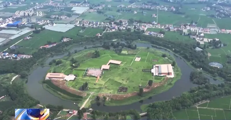 Chengtoushan Neolithic Site ·
 Plan your visit
Getting there
Lixian is about 75 km in a straight line from central Changde. Search for 澧县 in a map app to find stations and your accommodation.
Where to stay →Build your route
Start with Chengtoushan Neolithic Site. The linked place guides have entrance and visit details.
Continue with Changde →More in Changde
Sources & geographic information
Administrative names and parent areas: Official geographic directory · Reference date 2026-09-06.
Some facts checked against 澧县 — Wikipedia contributors, CC BY-SA 4.0.
Photo: Chengtoushan Neolithic Site · Source photographer · License not provided. EXIF orientation normalized; resized without changing aspect ratio; converted to WebP. No subject edits.
Map data © OpenStreetMap contributors. Pins mark approximate centres, not entrances or boundaries.