


Get to know Dorbod Banner
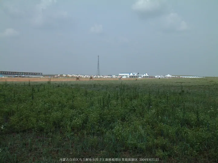
Photo adjustments
Full frame retained; proportionally resized and converted to WebP. No retouching or changes to the photographed subject. Card displays may crop the view.
- Administrative area
- Banner · 旗
- Part of
- Ulanqab
- Chinese name
- 四子王旗
- Local areas
- Banner guide
Area & population
- Area in the source
- 25,513.00 km²
- Population · 2020
- 129,372
- Administrative seat
- Ulan Hua
Source: cited geographic source, as of the dates shown.
Setting and landscape
From south to north the land passes from the northern edge of the Yin Mountains (阴山) through the Ulanqab hills onto the Mongolian Plateau, falling from southeast to northwest at heights of 1,000 to 2,100 metres. Neighbours are Chahar Right Middle Banner (察右中旗), Chahar Right Back Banner (察右后旗) and Sonid Right Banner (苏尼特右旗) to the east, Zhuozi (卓资县) and Wuchuan (武川县) to the south, and Darhan Muminggan Banner (达茂旗) of Baotou to the west. The banner government records a natural grove of more than 300 desert poplars (胡杨) on the Naomugeng (脑木更) grassland, calling it one of three such groves in China.
History
The name means "Four Sons". Noyantai (诺延泰), a fifteenth-generation descendant of Genghis Khan's brother Habutu Qasar (哈布图哈萨尔), had four sons, who submitted to Hong Taiji in 1630; their Four Sons tribe (四子部) was moved here in the early Qing from the Hulunbuir (呼伦贝尔) grassland, and in 1649 the third son, Ombu (鄂木布), was made head of the banner. The Jin dynasty set up Tianshan County (天山县) here in 1178, and in the Yuan it belonged to Jingzhou Circuit (净州路); the banner government lists the old city of Jingzhou (净州古城) among its sights.
What to see
The Shenzhou landing zone received the return capsules of Shenzhou 1 to 11 as well as the Chang'e 5 (嫦娥五号) return capsule, and memorials mark the landing points of Shenzhou 1 to 7, except Shenzhou 2. Since Shenzhou 12 in 2021 it has been the backup rather than the main landing site for crewed flights.
Gegentala Grassland (格根塔拉草原旅游景区) was among the first sites in China rated 4A. The banner government also names Xilamuren Temple (锡拉木伦庙), a Tibetan Buddhist monastery known in the Qing as the "Potala of the northern frontier", the old princely residence (王爷府), and a large group of Yuan-period ovoo cairns. The Red Cliff Terrace (红崖台地) of Mount Naomugeng, 45 km northeast of the Naomugeng township seat, stretches 15 km in Danxia-like peaks; the banner government describes its section as the most complete continental Lower Tertiary sequence in Asia. The banner government also reports abundant mammal fossils, including a rhinoceros fossil group it calls rare in China, and the mountain and a fossil burial museum form a national geopark.
Getting oriented
The banner government puts Dorbod 95 km from Hohhot, 200 km from the Ulanqab city government and 280 km from Erenhot (二连浩特). National Highway G209 runs through the whole banner, which reaches the Jining–Erenhot railway to the east and the Beijing–Baotou railway to the south.
Highlights
- Shenzhou landing zone 四子王旗着陆场: Landing site of Shenzhou 1 to 11 and Chang'e 5; memorials at six landing points.
- Gegentala Grassland 格根塔拉草原旅游景区: One of China's first 4A-rated scenic areas.
- Xilamuren Temple 锡拉木伦庙: Tibetan Buddhist monastery called the Potala of the northern frontier in the Qing.
- Red Cliff Terrace 红崖台地: 15 km of Danxia-like peaks on Mount Naomugeng, part of a national geopark.
- Desert poplar grove 胡杨林: More than 300 natural desert poplars on the Naomugeng grassland.
Sources for this guide
四子王旗 - 维基百科,自由的百科全书 · Chinese Wikipedia · CC BY-SA 4.0
四子王旗概况 - 四子王旗人民政府 · Dorbod Banner People's Government
格根塔拉 - 旅游资源 - 四子王旗人民政府 · Dorbod Banner People's Government
壮美•红崖台地 - 旅游资源 - 四子王旗人民政府 · Dorbod Banner People's Government
千古•胡杨林 - 旅游资源 - 四子王旗人民政府 · Dorbod Banner People's Government
Original English written from the listed sources and checked sentence by sentence against quoted extracts by a separate reviewer. Updated 2026-09-26.
Explore Dorbod Banner
Core places to explore, with English and Chinese names.
Dorbod Banner 四子王旗
Plan your visit
Getting there
Dorbod Banner is about 135 km in a straight line from central Ulanqab. Search for 四子王旗 in a map app to find stations and your accommodation.
Where to stay →More in Ulanqab
Sources & geographic information
Administrative names and parent areas: Official geographic directory · Reference date 2026-09-06.
Some facts checked against 四子王旗 — Wikipedia contributors, CC BY-SA 4.0.
Map data © OpenStreetMap contributors. Pins mark approximate centres, not entrances or boundaries.