


Get to know Xinghe County
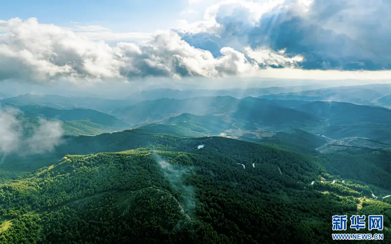
Photo adjustments
EXIF orientation normalized; resized without changing aspect ratio; converted to WebP. No subject edits.
- Administrative area
- County · 县
- Part of
- Ulanqab
- Chinese name
- 兴和县
- Local areas
- County guide
Area & population
- Area in the source
- 3,506.00 km²
- Population · 2020
- 167,881
- Administrative seat
- Chengguan
Source: cited geographic source, as of the dates shown.
Setting and landscape
The county runs about 109 km north to south and 67 km east to west, with its seat at Chengguan (城关镇). Sumu Mountain, 34 km south of the seat, borders Shangyi (尚义) in Hebei to the east and Tianzhen (天镇) and Yanggao (阳高) in Shanxi to the south. Its nature reserve is listed by the county as the largest planted forest farm in Inner Mongolia, with forest over about 75 percent of it; Huangshiya (黄石崖) rises to 2,334.7 m.
Zhengbei milkvetch (正北黄芪) from Danan Mountain (大南山) is, in the county government's words, the best known of the county's many wild medicinal plants, and its graphite deposits are named as one of China's three main graphite bases.
History
Sumu means "arrow" in Mongolian, and the county government records the mountain's earlier names: Arrow Mountain (箭山), Yanmen Mountain (雁门山) from the Spring and Autumn and Warring States periods to the Jin, and Panyang Mountain (蟠羊山) under the Northern Wei. The county itself began as Xinghe subprefecture (兴和厅) of the Guisui circuit (归绥道) in the late Qing and became a county in the early Republic.
What to see
Sumu Mountain is a 4A scenic area. Chaer Lake (察尔湖), also called Youyi Reservoir (友谊水库), is another 4A site at Yamenhao (衙门号) in Chengguan: a reservoir on the upper East Yang River (东洋河) in the Yongding system, surrounded by hills, with boating and horse riding among its activities. Laolihai (涝利海), beside National Highway 110, is made up of three bodies of water covering 120 hectares, the main one an oval natural lake; marshy grassland lies to the west and open pasture to the north, and the lake has become a stopover for migrating birds.
Getting oriented
The county government puts Xinghe 100 km from Zhangjiakou (张家口), 150 km from Datong (大同), 200 km from Hohhot and 240 km from Beijing. The Jining–Zhangjiakou railway (集张铁路) and the Beijing–Hohhot high-speed railway (京呼高铁) cross the county, and the G6 and G7 expressways pass through it.
Highlights
- Sumu Mountain 苏木山: 4A scenic area and forest reserve; its peak Huangshiya (2,334.7 m) is Ulanqab's highest point.
- Chaer Lake 察尔湖: 4A reservoir resort on the upper East Yang River.
- Laolihai 涝利海: 120-hectare lake and wetland beside National Highway 110 used by migrating birds.
- Zhengbei milkvetch 正北黄芪: Best-known wild medicinal plant of the county, from Danan Mountain.
Sources for this guide
兴和县 - 维基百科,自由的百科全书 · Chinese Wikipedia · CC BY-SA 4.0
区位交通 - 区位交通 - 兴和县人民政府 · Xinghe County People's Government
资源优势 - 资源优势 - 兴和县人民政府 · Xinghe County People's Government
苏木山简介 - 旅游兴和 - 兴和县人民政府 · Xinghe County People's Government
察尔湖(友谊水库) - 旅游兴和 - 兴和县人民政府 · Xinghe County People's Government
涝利海 - 旅游兴和 - 兴和县人民政府 · Xinghe County People's Government
Original English written from the listed sources and checked sentence by sentence against quoted extracts by a separate reviewer. Updated 2026-09-26.
Explore Xinghe County
Core places to explore, with English and Chinese names.
Xinghe County 兴和县
Plan your visit
Getting there
Xinghe County is about 60 km in a straight line from central Ulanqab. Search for 兴和县 in a map app to find stations and your accommodation.
Where to stay →More in Ulanqab
Sources & geographic information
Administrative names and parent areas: Official geographic directory · Reference date 2026-09-06.
Some facts checked against 兴和县 — Wikipedia contributors, CC BY-SA 4.0.
Map data © OpenStreetMap contributors. Pins mark approximate centres, not entrances or boundaries.