


Get to know Haizhou District

Photo adjustments
Full frame retained; proportionally resized and converted to WebP. No retouching or changes to the photographed subject. Card displays may crop the view.
- Administrative area
- District · 市辖区
- Part of
- Lianyungang
- Chinese name
- 海州区
- Local areas
- District guide
Area & population
- Area in the source
- 701.00 km²
- Population · 2014
- 1,101,000
Source: cited geographic source, as of the dates shown.
Getting oriented
Haizhou borders Lianyun District (连云区) to the north-east and east, Guanyun County (灌云县) to the south and Donghai County (东海县) to the west; the Xinshu River (新沭河) separates it from Ganyu (赣榆) in the north. The district government puts it 28 km west of Lianyungang port and 20 km north of Huaguoshan International Airport. High-speed lines to Shanghai, Xuzhou (徐州) and Huai'an (淮安) meet here, and the Lianhuo, Shenhai and Changshen expressways cross it. The Qiangwei River (蔷薇河) and the Yan River (盐河) wind around the hills and the city.
History
The district government traces more than 2,000 years of administration and says the First Emperor of Qin set up a stone here as the eastern gate of his empire. Haizhou city was first built in 512 under Emperor Wu of Liang, faced with brick and stone and given four gates in 1418, and badly damaged by the Tancheng earthquake of 1668. The wall was pulled down in 1956; the Quyang Gate (朐阳门) was rebuilt in 1995. The district government also says the novels Journey to the West and Flowers in the Mirror (镜花缘) were born here, and names Su Shi (苏轼) and Li Ruzhen (李汝珍) among the historical figures tied to Haizhou.
What to see
Mount Huaguo, called Cangwu Mountain (苍梧山) in the Tang and Song, is the main peak of the Yuntai range (云台山脉) and took its present name from the Flower and Fruit Mountain of Journey to the West. It is a national scenic area, and its Jade Maiden Peak, at 625.3 metres, is the highest point in Jiangsu.
Kongwang Hill, in the southern suburbs, is named for the story that Confucius climbed it to look out to sea. At the western end of its southern foot, 105 figures were cut into a cliff 17 metres long and 8 metres high in the late Eastern Han. Laozi (老子) and the Yellow Emperor (黄帝) are the largest and most honoured figures, with the Yellow Emperor placed highest; Buddhist scenes include the nirvana and the offering of the body to feed a tigress. The carvings became a national key protected site in 1988. The Jiangjunya petroglyphs (将军崖岩画), which the district calls the "heavenly book of the East", are another national heritage site in the district.
Highlights
- Mount Huaguo 花果山: Main peak of the Yuntai range; Jade Maiden Peak at 625.3 m is Jiangsu's highest point.
- Kongwang Hill cliff carvings 孔望山摩崖造像: 105 late Eastern Han figures mixing Laozi, the Yellow Emperor and Buddhist scenes; national key protected site since 1988.
- Jiangjunya petroglyphs 将军崖岩画: Rock art the district calls the "heavenly book of the East".
- Quyang Gate 朐阳门: South gate of the Haizhou city wall, rebuilt in 1995.
Sources for this guide
海州区情简介 · Haizhou District People's Government
海州区 (连云港市) - 维基百科 · Wikipedia (Chinese) · CC BY-SA 4.0
孔望山摩崖造像 - 维基百科 · Wikipedia (Chinese) · CC BY-SA 4.0
花果山 (江苏) - 维基百科 · Wikipedia (Chinese) · CC BY-SA 4.0
海州城墙 - 维基百科 · Wikipedia (Chinese) · CC BY-SA 4.0
Original English written from the listed sources and checked sentence by sentence against quoted extracts by a separate reviewer. Updated 2026-09-25.
Explore Haizhou District
Core places to explore, with English and Chinese names.
Places to explore around Haizhou District
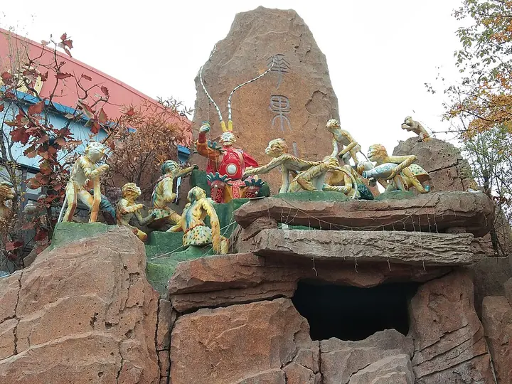 Outdoor Monkey King-themed display at Mount Huaguo, Lianyungang · 连云港花果山孙悟空主题景观 Photograph date recorded by the source: 8 November 2018, 13:40:15.
Mount Huaguo花果山
Lianyungang’s Huaguo Mountain brings the imagery of Journey to the West into a real landscape of wooded slopes, rock formations and temples. Yunu Peak offers the high mountain setting, while Shuilian Cave and Sanyuan Palace…
Read the place guide → Kongwang Mountain · 孔望山
Kongwang Mountain孔望山
Kongwangshan in Lianyungang is a hill of religious cliff carvings, sculpted stone and inscriptions left across different historical periods.
Read the place guide →Plan your visit
Getting there
Haizhou District is about 4 km in a straight line from central Lianyungang. Search for 海州区 in a map app to find stations and your accommodation.
Where to stay →Build your route
Mount Huaguo and Kongwang Mountain are both listed here. The linked place guides have entrance and visit details.
Continue with Lianyungang →More in Lianyungang
Sources & geographic information
Administrative names and parent areas: Official geographic directory · Reference date 2026-09-06.
Some facts checked against 海州区 (连云港市) — Wikipedia contributors, CC BY-SA 4.0.
Some facts checked against 孔望山摩崖造像 — Wikipedia contributors, CC BY-SA 4.0.
Some facts checked against 花果山 (江苏) — Wikipedia contributors, CC BY-SA 4.0.
Some facts checked against 海州城墙 — Wikipedia contributors, CC BY-SA 4.0.
Photo: Mount Huaguo · Jason M. C., Han · Jason M. C., Han — Monkey_King's_Homeland_-_Mount_Huaguo.jpg — CC BY-SA 4.0 · CC BY-SA 4.0. Full frame retained; proportionally resized and converted to WebP. No retouching or changes to the photographed subject. Card displays may crop the view.

Photo: Kongwang Mountain · Source photographer · License not provided. EXIF orientation normalized; resized without changing aspect ratio; converted to WebP. No subject edits.

Map data © OpenStreetMap contributors. Pins mark approximate centres, not entrances or boundaries.